
Walk Eighty. Loule - Salir Linear. 16k Ascent: 580m
GPS: 37/ 08. 30. 82 8/ 01. 28. 11
This is a linear walk, so you will have to make transport arrangements to get back to Loule from Salir.
The walk is an alternative to the one adopted by the Via Algarviana developers, designed to reach the main trail from railway stations or main towns further south. Starting in Loule itself, the walk is shorter and more direct than the VA route, passing through some attractive countryside, but with only one significant ascent to contend with. There is one place of refreshment on the route, at Funchais, and another at Nave do Barao. There is a river crossing involved, so after a lot of rain it may be advisable to give this one a miss.
Getting to the start in Loule.
From the A22 motorway, take the Loule Centro exit, and drive towards the town. At a sign for ´Zona Industrial´, turn off. Go round the roundabout below the fire station (Bombeiros), and come down to another roundabout, where you go straight on. Go straight on at the next roundabout, signed left to Boliqueime, and at the next roundabout, The Rotunda de Salir, turn right. go down past the bus station on the left, and at the main road junction turn left. Almost immediately, turn left again uphill on the other side of the bus station. Go across the exit from the bus station at the top of the rise, and park on the rough ground on the right.
To reach the start of the walk on foot, go back down to the main road and turn right. The start point is at the third turn on the right, the Rua Anastasia Dourado.
The Walk.
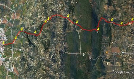
From the start point (1), walk up the road. Soon leave buildings behind, and after 420m, pass under the Louole bypass road that you came in on. After another 230m, find a path on the left behind an old field wall, (2) and turn into it. Follow the track down into a shallow valley, and after almost 500m, meet a track coming in from the left along the valley floor. (3). Continue walking, now due north, along the valley for another 670m, at which point the track appears to end (4) Turn right and find a path going uphill. It swings round to the right and then left, turning into a much broader path leading up to a tarmac road. Walk up the road for almost 700m. Pass a turn to the right (5) and after another 100m of steeper climb reach a T junction, and turn right.
After a short distance, see a gate facing you. (6). See a path to the left of the gate and follow this. After about 150m, it turns sharp left and soon comes to another tarmac road. Turn right. Walk for just over 800m through the commuter suburb of Val Telheiro, and arrive at a fork. (7) Take the right hand, tarmac surface, and walk for 380m to another fork, this time taking the left. Pass two large villas on the left and come to yet another fork, with a third house on the right. (8) Here take the right hand option, which is a dirt track. The track winds its way over a broad moor and then starts to descend, heading north all the time. After just over 1k, find a track on the left. (It´s the only one you will see) (9). Follow this across the face of the hill and then down to join a wider track heading north, after 730m. Turn right and come down to a river crossing. Cross, either dry or by paddling.
The exit from the river is diagonally to the left. A few metres into the track on the far side, bear right at a track junction. (10). Soon pass a building with two round blocks, and after 500m bear left at a fork.(11). Another 300m brings you to the corner of a football ground. Turn left and then right to walk round two sides of the pitch, and at a T junction soon after completing the second side, turn left and very shortly right.(12). 280m along this traight lane, come to a main road, and cross over, continuing straight up the hill into the village of Funchais. There are two bars here, one along the first lane to the left, the other after the road bends round to the right further up.
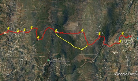
To continue the walk, at the point where the main road bends round to the right, go straight ahead instead, up a tarmac lane, ascending quite steeply (13). After 100m, turn left along a tarmac lane, and after another 120m, follow it as it turns right and climbs. After 200m come to a junction with another lane, and turn right. (14). Wind between houses, pass another house on the left and after 120m, come to a junction. Turn sharp left here and pass along the back of this rather scruffy looking property, with large hoardings blocking the view on the left. At a fork in the track, take the right hand, which is a stony path leading steeply uphill. After 240m, at another fork, take the right hand and continue to climb.(15). The gradient becomes a little easier, and after another 300m, come to a junction with a wide dirt road and turn right.
Now walk along more or less level round for 500m, to reach a junction with a track on the left. (16). Turn here, and follow this as it descends very gently, with cultivated land on the left. After around 800m come to a junction and bear right, following the obvious hard surface. Now wind through the ruins and occasional occupied house of the hamlet of Nave das Mealhas. On the far side of the settlement, there is a choice of routes.
1. For the more adventurous . Close to the hamlet boundary sign, see an opening on the left which looks like access to a ploughed field. (17). Walk into this, and as you head down, pick up a path heading down towards the valley. The path passes by a small concrete shed and then winds around old terraces on its way to the valley floor. A straight section at the end leaves you at the bottom. Now head due north across the flat valley. (In winter, this valley sometimes floods, so should be avoided. You will see the lake from above.). Reaching the far side, pass to the right of a section of broken wall and into the trees. Find a path heading steeply uphill and climb to reach a main tarmac road. Cross over and see where people have scrambled up the rocks. Climb up and see a rough path heading up the hillside. (18). Follow this for about 170m, until it meets a track contouring the hill, and turn right along it. After 550m, emerge onto a narrow tarmac road and turn left.
2. For the more cautious. Walk along the road from Nave das Mealhas for 1.4k, to arrive at a junction with a main road. Turn left and immediately right to enter another narrow tarmac road, signed to Covoes. Walk up this road, passing the point where the ´more adventurous route comes in after about 270m.
Walk up the road into the hamlet of Covoes. Pass the first group of houses and start to climb gently. Find a dirt track on the right opposite a municipal waste bin, and turn into it (19). Go down the steep hill, passing a well, after which the track becomes a hard surface, and continues down to join a main road. Turn left and follow the road across a long bridge, after which it turns left and starts to climb.This is a rather dangerous section of road, walk in single file. 450m from the end of the bridge, on a left hand bend, find a narrow tarmac lane on the left (20). Walk along this, and carry straight on when the surfaced road turns to the right. Follow the dirt track for just under 400m, and at a fork bear right (21) to follow field paths due north towards the buildings of Salir above. After 270m do a short detour left and right around trees, to continue the northward trend, walking quite steeply uphill to reach a tarmac road. Turn left to find the Bar Opcao on the right afteer 100m, or turn right and then left before the GNR post to make your way into the centre of Salir. You can follow signs to the church (Igreja), which would make a fitting end to the walk.
GPS Points. (37/8)
| 1 | Loule | 08 | 30 | 61 | 01 | 28 | 27 | |||
| 2 | Turn left | 08 | 47 | 86 | 01 | 39 | 42 | 680m | ||
| 3 | Straight on | 08 | 54 | 42 | 01 | 56 | 18 | 490m | ||
| 4 | Turn right | 09 | 14 | 47 | 01 | 53 | 61 | 650m | ||
| 5 | Straight on | 09 | 27 | 93 | 02 | 15 | 06 | 850m | ||
| 6 | Bear left | 09 | 31 | 35 | 02 | 19 | 93 | 180m | ||
| 7 | Turn right | 09 | 58 | 82 | 02 | 28 | 73 | 1k | ||
| 8 | Turn right on path | 10 | 12 | 11 | 02 | 19 | 85 | 480m | ||
| 9 | Turn left | 10 | 43 | 80 | 02 | 11 | 67 | 1.1k | ||
| 10 | Fork right | 11 | 02 | 70 | 02 | 32 | 08 | 1.26k | ||
| 11 | Fork left | 11 | 17 | 35 | 02 | 27 | 32 | 470m | ||
| 12 | Turn right | 11 | 32 | 23 | 02 | 36 | 62 | 630m | ||
| 13 | Straight on uphill | 11 | 46 | 37 | 02 | 33 | 98 | 450m | ||
| 14 | Turn right | 11 | 55 | 90 | 02 | 37 | 07 | 340m | ||
| 15 | Fork right | 12 | 65 | 57 | 02 | 42 | 43 | 440m | ||
| 16 | Sharp left | 12 | 16 | 60 | 02 | 26 | 74 | 800m | ||
| 17 | Left off road | 12 | 39 | 88 | 02 | 41 | 71 | 1.16k | ||
| 18 | Climb up from road | 13 | 15 | 98 | 02 | 47 | 41 | 1.2k | ||
| 19 | Turn right | 13 | 40 | 29 | 02 | 45 | 23 | 1.34k | ||
| 20 | Turn left | 14 | 09 | 81 | 02 | 35 | 58 | 1.34k | ||
| 21 | Bear right | 14 | 11 | 84 | 02 | 49 | 87 | 400m | ||
| END | Cafe Opcao | 530m |
NOTE: North is right.
Alternative route in yellow, not described.
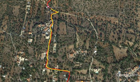
Route through Funchais.