
Introducing The Algarve Way.
There are in fact two major routes across the Algarve, though one is now much more prominent and better known. The established route now is the Via Algarviana, an internationally recognised long distance path, marked with the obligatory red and white markers and finger posts. It was established during the first decade of the century by the environmental association Almargem, using funds from the EU, and it is maintained in the same way, with assistance from the local authorities in the Algarve.
A good while before the VA was created, however, another initiative was launched to devise a cross-Algarve walking route. The rationale behind the idea was to recreate a pilgrim route from Spain to Cabo de Sao Vicente (Cape St. Vincent) at the far southwest corner of Portugal. It was the brainchild of Maurice Clyde, a walker from the UK, who worked with members of the Algarve Wednesday Walkers, founded round about 1996, on the scheme. In the early years, Almargem was also involved, but the joint effort did not really prosper. The route was worked out and walked in the late 90s by small groups of the AWW, but it was never formally mapped or marked at that time, although Maurice did promote it as a route. Indeed, in 2002, it was walked solo by a brave American who came all the way from his job in Istanbul to do it. Shortly after this, Maurice suffered a severe stroke which ended his walking days, and the Algarve Way went into abeyance. The project was picked up in 2004 by myself and another member of the AWW, Terry Ames. We decided to revive the plan, and to make it more accessible by marking and recording the Way. It took the best part of two years, but the aim was achieved. We recorded the whole route, marked it at intervals with the iconic flower of the Algarve, the gum cistus, and created a website with detailed guides to each stage. The route was walked a few times in various ways, and Terry Ames led several groups over the whole or part of the route as a professional guide. While this was going on, the official Via Algarviana was being created, and it rapidly became the go to option for anyone wishing to attempt the crossing of the Algarve. Maintaining the waymarking of the Algarve Way proved too dificult a task, and keeping abreast of any changes to the roads and tracks was also something that could only be done by a small army of volunteers, which we did not have. So the route was basically abandoned, the website taken down a couple of years ago.
As part of my website of circular walks, I have decided to record the original Algarve Way stage by stage, with detailed directions, so that it can be followed by anyone wishing to use it. The route lies totally along easily navigable trails, so no one should fear getting lost. If anyone does undertake this route in preference to the VA, please let me know how you get on!
Notes about the AW and the VA.
The two trans-Algarve routes,as one might expect, follow the same tracks for quite large parts of the way, and walkers will become familiar with the red and white markers. There are, however, significant differences between the two. The AW is a remarkable 40k shorter than the VA (260 as opposed to 300), largely because it follows a rather straighter course, especially on the very first stage. While the VA has developed all the ancillary aids to walkers such as accommodation lists and descriptions of flora and fauna, my revival of the AW sticks strictly to the task of getting the walker from A to B, which is all I can really do. I am happy to provide whatever additional information I can through direct contact, but I cannot guarantee to be a fount of all knowledge. Accommodation was always a problem on the eastern sections, moreso on the AW, as this route tends to avoid centres of population, such as they are. From Barranco do Velho onwards to the west, the situation is much easier. I would personally recommend anyone planning to walk the AW with my instructions to have a support vehicle as part of their arrangements. Some of the stages are long and quite demanding, and breaking them down into smaller chunks is only possible with support. (Bear in mind that wild camping is illegal in Portugal).
One major difference between the VA and the AW is that the latter has an alternative route in the later stages. From Marmalete, in the Monchique hills,one can go staright towards the coast via Aljezur and thence to Carrapateira walking due south, or take an inland route to Bensafrim at the end of the A22 motorway, heading from there over to the sea at Carrapateira. The last stage down to the Cape follows a single pathway.
My Method.
I have used exactly the same methods of recording as with my local circulars. Each stage is described in words, with every significant twist and turn recorded. The stages are recorded on Google Earth, with GPS points set at intervals. Distances between GPS points are set down in a table, and intervening distances are included in the text.Changes of direction and gradient are recorded in detail to assist confidence. Details of how to get to the start and finish of each stage are also recorded, together with ideas for support vehicles to intervene in some stages. If anyone has ideas as to improvements that might be made to all this, please let me know.
Getting to start and finish points on the Algarve Way
Getting to Alcoutim.
There are two main routes – a) The 124 road from the west via Salir, Barranco do
Velho and Martim Longo.
b) The IC27 from Castro Marim.
Parking. On arrival, cross the Cadavais river bridge. Covered parking bays are available on the right.
By Vehicle to Soudes.
Leave Alcoutim on the Martim Longo/Cachopo road (124). Turn left down the 122 (IC27) after 6k, and right towards Zambujal after another 13k, on the 505. Soudes is 9k along. The distinctive windmill is your best landmark.
Coming from the south, take the 122 (IC27) from Castro Marim or the motorway, and drive past Azinhal and Odeleite. 4k on turn left towards Zambujal on the 505.
By Vehicle to Monte de Ribeira.
Drive west from Soudes to Zambujal and continue along the 505 via Malfrades, Monchique, and Amoreira. Turn left at the junction with the 397 Tavira road. Ribeira is about 10k along, in a valley with cafes on both sides of the road. It is not marked on all road maps.
Getting to Barranco.do Velho.
From Ribeira, drive north-west to Cachopo on the 397, and then turn left along the 124 for Barranco via Feiteira and Montes Novos. The whole journey is about 34k, but on very winding roads.
From the south, leave the motorway at junction 5 and take the N2 for Sao Bras and Almodovar. Barranco is about 20k from the motorway, and the junction with the 124 road for Cachopo is your rendezvous point, outside the Tia Bia Pensao and Restaurante.
By vehicle to Benafim.
Drive west along the 124 past Salir and Pena. Your rendezvous is before Benafim proper, at a roundabout with cafes on both sides of the road.
From the south, leave the A22 at the Boliqueime junction and follow signs to Loule. Past the quarry workings, take the first left. At the T junction in Parragil, turn left and follow this road down to a river crossing and then up a long hill to Alto Fica. Continue on the same road down into a valley and back up again to Benafim. Park near the roundabout.
Getting to Messines
Drive west along the 124 via Alte to Messines. At the first roundabout, signed to the A2 Motorway, take the second right for Messines. The walkers will come into the town on the next road on the right. From the south, take the A2 motorway or the IC1 main road from near Albufeira, and come off at the Messines exit. From the motorway, take the first right to meet the walkers east of Messines. From the IC1 follow signs for Salir until facing the motorway toll-booths at a roundabout, then turn left.
If it is intended to by-pass Messines, but to have a rendezvous, follow these instructions:
From the roundabouts on the approach to Messines, follow signs for Silves. These take you round the Messines by-pass. Take what is in fact the third turn into Messines, (second from the ICI) turning right and travelling back towards the town from the west. (If you pass a petrol station on the left, you have gone too far.) Follow this road until you reach a junction with an AGIP petrol station on the left. Turn sharp left here, and follow the road through the suburb of Furodouro, round a hill to the right, with the railway on your left. At a point where a new small valley opens up in front, see a track coming out on the right. This where the walkers will emerge having by-passed the town.
By vehicle to Silves.
Drive along the 124 main road between the two towns. At the double roundabout on the outskirts of Silves, take the second on the right which goes to the left of the town cemetery. Take the first right after the cemetery. Rendezvous where the Silves irrigation canal goes under the road to Sao Marcos da Serra, about 300m along.
From the West and South:
Leave the A22 motorway at the Silves/Lagoa junction, and drive towards Silves. Turn left to cross the river facing the castle, and right at the lights. At a double roundabout, go round the first, across a short link and take the road ahead going to the left of the cemetery. Turn right past the cemetery. Rendezvous as above.
By vehicle to the Odelouca Crossing..
Take the 124 road out of Silves towards Portimao and Monchique. After about 10k, cross a river and take the next right immediately afterwards, by a small bar. (If you pass the Ourique Restaurant on a bend on the left, you have gone too far.) Follow this road north for another c10k to the hamlet of Cortes. Shortly after this, on a hill, take a wide gravel road on the right, heading slightly downhill. Look for a small shed over the bank on the right. This is where the walkers will emerge.
From the West and South.
Leave the A22 motorway at Portimao and take the Monchique road. Fork right for Silves along the 124, and take a left turn after c.3k before a river bridge, by a small bar, shortly after passing the Ourique Restaurant on the right. From here follow the instructions in the paragraph above.
By Vehicle to Monchique
Instead of taking the road to the Odelouca valley as above, from Silves carry on to the junction with the 266 Monchique road; Monchique is about 16k up the road into the hills. On reaching the town, turn into the café and garage complex by the traffic lights. This is the most convenient place to meet the walkers, who will come down the road on the right just beyond the café etc.
From the south, leave the motorway at the Portimao exit, and follow signs to Monchique.
By vehicle to Monchique. from the Odelouca crossing.
From the Odelouca crossing point, continue up the road to Alferce. Turn left towards Monchique. Reaching the traffic lights, turn left and left again into the forecourt of the garage and café.
By vehicle to Marmalete.
From Monchique, take the 266 back towards the coast. Opposite the huge quarry on the left, turn right, signed Casais and Marmalete. This road will take you straight to Marmalete, about 16k further on. Drive about 200m into the village, and turn left down into a small square with a café on the right. The walkers will meet you there.
From the south, follow signs to Monchique from the Portimao exit from the motorway. Approaching Monchique, see a huge quarry on the right, and turn left signed to Casais and Marmalete.
By Vehicle to Aljezur.
From Marmalete, simply follow the main road west and Aljezur will get in the way before you fall into the sea, about a 15 minute drive. Park on the left before the river bridge. The walkers will come down this road. Coming from the south, drive to the western end of the A22 motorway at Bensafrim, and take the first turn left at the roundabout. This will take you straight to Aljezur. Turn right over the river and park.
By Vehicle to Carrapateira
Turn left after the Aljezur bridge, and drive south. Turn right at a turn signed to Alfambras, Bordeira and Carrapateira, and follow this road all the way to Carrapateira. Park on the right opposite the village centre..
From the south, leave the motorway at Bensafrim and follow signs for Aljezur. At a hilltop close to wind turbines, turn left for Alfambras, and follow this road to a T junction signed left for Lagos. Follow this road all the way to Carrapateira.
Getting to Marmalete
From Monchique, drive down the road from the previous rendezvous point towards Portimao, and turn off at the first major road on the right, opposite a huge quarry, signed for Casais and Marmalete. Marmalete is 16k along this winding mountain road.
By Vehicle to Bensafrim
From Marmalete, drive along the main road west to Aljezur. Cross the river bridge and turn left. Follow this road all the way to Bensafrim, which is at the end of the A22 motorway. Take the first left off the roundabout to reach the town. Turn left at the open space off the main street with the market and café on the far side. The walkers will meet you at the café.
From the east, follow the A22 motorway to the end, and turn right into Bensafrim from the roundabout – then as above.
Getting to Bensafrim
From Marmalete, drive along the main road west to Aljezur. Cross the river bridge and turn left. Follow this road all the way to Bensafrim, which is at the end of the A22 motorway. Take the first left off the roundabout to reach the town. Turn left at the open space off the main street with the market and café on the far side. The walkers will meet you at the café.
From the east, follow the A22 motorway to the end, and turn right into Bensafrim from the roundabout – then as above.
By Vehicle to Carrapateira.
From Bensafrim,and the A22 motorway, take the 120 north towards Aljezur. After 13k, at the junction with the 268, turn left and follow this road for another 13k to Carrapateira. Park in or opposite the town square, where the walkers will join you.
Getting to Carrapateira
From Bensafrim,and the A22 motorway, take the 120 north towards Aljezur. After 13k, at the junction with the 268, turn left and follow this road for another 13k to Carrapateira. Park in or opposite the town square, where the walkers will join you.
From Aljezur, follow the 120 south to the junction with the 268, then turn right and follow as above.
By Vehicle to the Cabo de Sao Vicente
From Carrapateira, follow the 268 south to Vila do Bispo, where it joins the main coast road to Sagres. Follow the main road through the outskirts of Sagres, signed to the Cape. The lighthouse will be your guide as you near the Cape itself. Do not try to go any further. There is ample car-parking for you to await the arrival of weary walkers.
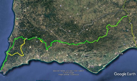
The whole route. Yellow line on the right is the Spanish border. Yellow line on the left is the Bensafrim - Carrapateira alternative route.