Walk Seventy Nine. Sarnadas - Macheira - Joao Andrez Circular.
12k. Ascent: 480m Extension: 3.5k more. Ascent:380m
GPS: 37/16. 06. 17 8/ 09. 10. 62
Sarnadas is a small but very attractive village a few k north of Alte and Benafim, but it feels more remote than that, as between it and those two small towns sits the mass of Rocha dos Soidos, towering over the surrounding countryside. The village boasts a thriving bar/ cafe which serves lunches, and a restaurant open to private bookings. The basic walk from here is short but varied, with a climb to a high point affording excellent 360 degree views. An extension involves quite a lot more climbing, with further vistas.
Getting to Sarnadas.
The easiest way is to drive to Benafim on the N124. Come from Silves/ Messines from the west or Salir from the east. From the south come off the A22 motorway at Boliqueime and follow signs to Loule. At a junction after the quarry turn left and at the next T junction turn left. Now follow this road down into a valley and across a narrow bridge, then continue up and over the next hill and on to Benafim. From all directions, come to a roundabout at the eastern end of Benafim and turn north uphill. Follow this road over the hill and down into a valley, seeing a small tourist resort on the right at the bottom. About 1k further on come to a turn to the left signed to various places, including Sarnadas. Drive to the village, parking as soon as possible after the first houses, as you cannot park in the middle. Restaurant and cafe are on the right as you walk through.
The Walk.
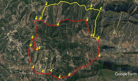
With your back to the cafe, (1) turn right and walk for about 100m. Find a turn to the left down a very narrow alleyway, with a water tap just beyond it. Turn down here and follow this lane, which widens out, crosses the floor of the valley and swings right uphill, turning into a dirt track after a large house on the left. After just over 800m, come to a T junction with a tarmac road. (2) Turn right and walk along the (very quiet) road for 1.6k, with the bulk of Rocha dos Soidos immediately above on the left. Towards the end of this distance, pass a house on the right with a gate across the path leading to it, and 100m or so further on see a track on the right leading off downhill at an acute angle to the road. (3)
Walk down this track for about 230m, to a point where the track makes a distinct turn right to go further downhill. Here turn left and follow rough tractor marks and open land southwesterly for just over 200m, to meet another clear dirt track heading downhill. (4). Turn right and follow this track as it winds down to the valley floor. Ignore one minor turn to the right, and at a track junction after 550m, turn left (5). 240m further on, come to a tarmac road and bear left. After 150m at a junction turn right, and very quickly turn left, still on tarmac (6). The village above you on the right is Macheira,
After 500m, just before a tarmac turn to the left, take a dirt track on the right uphill (7). Walk around 370m almost due north to reach a junction, with a house immediately beyond it. Go straight ahead, leaving the house on the left, and climb steeply in two big ´steps´ for the next 650m. At this point (8), the track turns right and continues to ascend for another 340m, to reach a trig pillar at a summit called Picota. (9). Do stay here and admire the view fior a few minutes.
Now you need to retrace your steps for a short distance, down the steep slope leading to the summit. Take the first on the right, a very sharp turn onto a clear dirt track heading round the north side of the peak. After 170m, find a narrower track on the left, another very sharp turn. (10). Follow this track northwesterly, then turning more northerly, as it winds down to the valley over the next 770m. Cross a stream or dry bed at the bottom and climb a few metres to a narrow tarmac road. (11). Turn right and walk uphill at first, then down and up again into the hamlet of Joao Andrez after a further 1.1k.
After the first house on the right, turn right down a dirt track (12). Follow this for just over 1k, passing one house up on the hill to the left, and come down to a junction of several tracks. (13). Take the first on the left, a stony track that wanders in undulating fashion around the hill to the right for 1.5k. Stay in the valley past two or three turns uphill on the left, and emerge onto a tarmac road. (14). (Just before the road, there is a turn down to the right which leads onto a narrow path beside the tarmac, avoiding part of the road walk to come). Turn right down the road and walk for 750m, rounding a sharpish bend at the end. See a narrow tarmac road in front, with a cul de sac sign (15), and walk along it. (The dead end is for motorists). Climb a short rise into the houses of Sarnadas, and arrive in a small yard with no road exit. Find a narrow alley over on the right and walk through it to the main road through the village. Turn left to walk along to the bar.
For the Extension.
170m after Point 12, come to twin tracks on the left. Take the second one, (1a) heading steeply uphill northeasterly. The track climbs more or less steeply up a ridge for almost 700m, to reach a T junction on a ridge running east - west. (2a) Turn right and now simply follow the ridge on an undulating course for the next 2.3k, with excellent views the whole way. Come to a tarmac road. (3a). Turning right here, you can walk down the road all the way back to Sarnadas, an easy descent. If you wish to complete the walk on tracks, walk to the right over the rise and take the first turn to the left, a sharp turn onto a dirt track leading uphill. Follow this for just over 400m to find a track on the right heading off downhill on a ridge. (4a). Follow this all the way down to the valley, hitting a narrow tarmac road. (5a). This is the road leading into Sarnadas from Point 15. Turn left and walk into the village.
GPS Points.
| 1 | Sarnadas | 16 | 05 | 89 | 09 | 10 | 92 | |||
| 1 | Turn Right | 15 | 41 | 37 | 09 | 11 | 70 | 840m | ||
| 3 | Bear right | 15 | 14 | 96 | 10 | 04 | 48 | 1.6k | ||
| 4 | Turn right | 15 | 11 | 19 | 10 | 21 | 26 | 460m | ||
| 5 | Turn left | 15 | 20 | 00 | 10 | 36 | 33 | 520m | ||
| 6 | Turn left | 15 | 18 | 69 | 10 | 51 | 16 | 430m | ||
| 7 | Turn right | 15 | 24 | 78 | 11 | 08 | 29 | 500m | ||
| 8 | Right with track | 15 | 55 | 72 | 11 | 11 | 43 | 1k | ||
| 9 | Trig point | 15 | 50 | 53 | 11 | 00 | 10 | 320m | ||
| 10 | Sharp left | 15 | 52 | 14 | 10 | 36 | 45 | 260m | ||
| 11 | Turn right | 16 | 06 | 74 | 11 | 09 | 81 | 660m | ||
| 12 | Turn right | 16 | 34 | 24 | 11 | 03 | 06 | 1.1k | ||
| 13 | First left | 16 | 25 | 24 | 10 | 24 | 07 | 1.12k | ||
| 14 | Turn right | 16 | 31 | 61 | 09 | 32 | 61 | 1.5k | ||
| 15 | Bear left | 16 | 09 | 79 | 09 | 25 | 24 | 760m | ||
| End | 430m | |||||||||
| 1a | Turn left | 16 | 34 | 00 | 10 | 56 | 28 | 190m from 12 | ||
| 2a | Turn right | 16 | 53 | 31 | 10 | 44 | 27 | 680m | ||
| 3a | Turn right | 16 | 51 | 01 | 09 | 25 | 42 | 2.3k | ||
| 4a | Turn right | 16 | 46 | 38 | 09 | 09 | 67 | 510m | ||
| 5a | Turn left | 16 | 09 | 84 | 09 | 21 | 41 | 1.18k | ||
| End | 380m |