Walk Ninety. Querenca Circular. 15.5k Ascent 600m. GPS: 37/ 11.56.95 7/ 59. 14. 39
The village of Querenca sits on a hill to the north of Loule. The centre, to which one must climb from every direction, is an attractive open space, remodelled about 10 years ago, containing the church, two restaurants and a bar, a museum and local council buildings. It is an ideal start point for a number of walks, surrounded as it is by a mix of small settlements, shady river valleys and steep climbs to high ridges. (See the Walk ´Querenca Heights´ for a demanding outing).
Getting to Querenca.
Leave the A22 motorway at the Loule Centro junction, and turn north towards Loule. At a junction marked to Sao Bras and Zona Industrial, turn off and follow the road round a roundabout, with the fire station (Bombeiros) up to the right. Come back down the hill to another roundabout with an iron sculpture and go straight across. Follow signs to Sao Bras through another two roundabout, and at the third one, by a large sports centre, turn left,signed to Querenca. Drive for 8.7k, first on a fairly straight road and then through hilly country on a winding route. See a turn to the left up a steep hill, signed to Querenca. Drive up and park about two thirds of the way up, on the right. Leave the car and turn right up the remainder of the hill to the village centre.
Coming from the west along the N124, pass Alte, Benafim and Salir. Just over 4k past the roundabout at Salir with a large red sculpture, turn right, signed to Querenca.Drive for around 5.5k, passing Cerro da Cote, Corcitos, Cerca Nova and Cardosal. Come to a crossroads with a steep hill facing, and drive up to the car park as above.
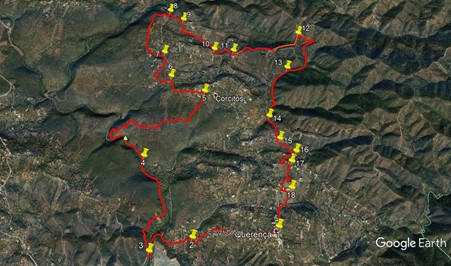
The Walk.
With your back to the Bar in the square, turn right and follow the road, taking the right hand at the fork and passing the local council (Junta) building. The road, narrow and very quiet, leads gently downhill for 1.2k. Arrive at a junction facing across a valley and turn right. (2). After a couple of hundred metres, rise to join a wider road and stay left to descend gently. Pass the entrance and car park to a local beauty spot , Fonte de Benemola, and carry on down the hill and round a corner to pass a derelict building on the left with a pond alongside, and turn right to cross a bridge.
Immediately after the bridge turn right (3) on an ascending dirt track. Ignore any turns to the left going steeply uohill, and follow the track as it climbs and then descends over the next 1.1k. Pass a cottage up on the left and another down on the right opposite, and continue for another 470m to come down to a stream crossing with concrete stepping blocks and a very useful rope. (4). Turn left on the far side and walk along the eastern bank, passing a picnic area. After c470 m, the path begins to climb and curve round to the right. A long and quite rocky climb follows for the next 900m. After levelling out, the track heads roughly eatwrds for a time, then turns northeast, coming after about 1k to the bottom of a short steep slope heading towards a small settlement (Corcitos).
At the top of the slope, turn left (5), and follow a narrow tarmac road through part of the village. Past the houses, walk gently downhill, turning right with the road at a junction with a track after 500m. Continue on the road for another 180m to a junction of tracks, and take the first on the left (6). This runs level for a short time before climbing quite steeply towards buildings. The track runs in a wide curve to the right below the houses, and after 600m come gently down to join another track. (7). Turn left and now climb again through a wooded area, the Cerro da Corte. Pass a house on the left at the top of the climb, and go on through the woods before descending steeply to a tarmac road after 1.1k. Turn left and walk down for a few metres before turning right at a junction (8)
Now walk up and along another tarmac road, and after 270m, see two farm tracks leading off on the right. (9) Take the second one, heading more or less due south, and follow it for 150m, then turn left with the track and walk across fields for 360m to reach a tarmac road. Turn right and walk uphill for 320m, round a left hand curve, to a junction. (10). Turn left, and at a fork after 200m bear right uphill. At a junction with a track after 160m (11), follow the tarmac round to the left. The tarmac ends shortly, with ruins on the right and occupied houses on the left through trees. Continue on what is now a dirt road, climbing quite quickly, for 600m. At a fork, take the left hand and continue to climb through woods for 350m, then turning left to emerge onto more open land, arriving at a fork after another 150m. (12)
Take the right hand option here and almost immediately swing sharply to the right. At a fork after 150m take the right hand and follow the winding track as it describes a tight right hand curve over the next 340m. Now the track turns left and descends steeply, due south, over the next 300m before curving to the right and going down more gently for another 300m. At a fork (13) take the left hand and continue to descend steadily over the next 600m. At a junction with a track going left, stay right and after another 180m turn left with the track at a point where you see a tarmac road just over to the right. (14). From here, climb up for 300m to reach a cluster of buildings, and then drop down gently to a tarmac road. (15).
Turn left and walk for 300m to a sharp turn to the right just before a small fonte or shrine.(16). Walk up and along for 240m to another rod junction and turn left. After 140m, just before a house on the right, turn right down a field path heading due south. (17) After about 180m, the path bends through a small copse to come to a junction with another path. Turn right here and pass in front of a house, at which point the surface turns to tarmac. 170m from the house turn left at a junction, and 120m further on turn right. (18). Walk up to a main road, 180m, then turn right and after 100m, turn left up the hill back to your car and refreshments in Querenca.
GPS Points. 37/8/7
| 1 | Querenca square | 11 | 56 | 95 | 59 | 14 | 39 | |||
| 2 | Turn right | 11 | 52 | 36 | 00 | 00 | 14 | 1.22k | ||
| 3 | Turn right | 11 | 46 | 70 | 00 | 23 | 13 | 880m | ||
| 4 | Turn left across bridge | 12 | 27 | 98 | 00 | 29 | 51 | 1.65k | ||
| 5 | Turn left | 12 | 58 | 42 | 59 | 55 | 11 | 2.57k | ||
| 6 | Turn left | 13 | 06 | 50 | 00 | 15 | 59 | 660m | ||
| 7 | Turn left | 13 | 18 | 49 | 00 | 20 | 22 | 620m | ||
| 8 | Turn right | 13 | 41 | 99 | 00 | 18 | 26 | 1.17k | ||
| 9 | Turn right on footpath | 13 | 37 | 23 | 00 | 09 | 94 | 270m | ||
| 10 | Turn left | 13 | 20 | 68 | 59 | 50 | 09 | 830m | ||
| 11 | Turn left | 13 | 19 | 77 | 59 | 38 | 41 | 360m | ||
| 12 | Fork right | 13 | 28 | 86 | 58 | 59 | 07 | 1.16k | ||
| 13 | Fork left | 13 | 10 | 95 | 59 | 06 | 30 | 1.11k | ||
| 14 | Stay left | 12 | 46 | 82 | 59 | 15 | 78 | 900m | ||
| 15 | Turn left | 12 | 35 | 94 | 59 | 11 | 90 | 390m | ||
| 16 | Sharp right | 12 | 30 | 07 | 59 | 02 | 98 | 300m | ||
| 17 | Turn right (path) | 12 | 25 | 25 | 59 | 05 | 90 | 420m | ||
| 18 | Turn right | 12 | 13 | 42 | 59 | 06 | 46 | 570m | ||
| End | 600m |