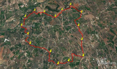
Walk Eighty Nine. Casinhas Circular. 16k. Ascent: 400m. GPS: 37/8 11. 36. 57 24.12.46
The valley of the Arade River is one of the most fertile in the Algarve, famous for the quality of its oranges, and increasingly of avocados too. There is some anxiety presently about the drain on the region´s water reserves caused by the ever expanding plantations, especially in this valley. This walk is a comparatively easy meander around the low hills on the south side of the valley, with some views over to the coast and north to Monchique. I am indebted to John Hope for the route.
Getting to Restaurant Cazinhas. The starting point for the walk is a well known local restaurant situated to the east of Silves, the ancient capital of the Algarve from Moorish times. To get there, leave the A22 motorway at the Silves/Lagoa exit and travel to Silves. In sight of the town and castle, turn left to cross the river, and then go right at the traffic lights. Drive out of town on the N124 for 1.3k, past one roundabout, and take the first right after that, with a small roundabout at the entrance to the minor road. Follow this for almost 2.7k, a winding route, and then see Restaurant Casinhas on the right at a junction.
Coming from the east along the N124 from Messines, the turn to the left comes immediately before a long bridge over the Arade near Pedreira. You can see the bridge over on your right as you approach the turn. Take care, as this is quite a dangerous turn on a bend. Follow the narrow road for 1.7k, and turn right at a junction. After another 1.3k, see the restaurant on the left at a junction.
The Walk. With your back to the restaurant, (1) Turn left and immediately right. After 190m, turn left on a tarmac road and walk along for 550m. Come to a point where two lanes lead off on the right, and take the first one, which turns very sharp right, (2) and heads uphill. After around 130m, the track goes round a left hand curve, passes between buildings and heads out into planted fields. The track heads northeast uphill, kinks left and right, and after around 390m, comes to the edge of the plantation. Now take a track on the left which curves round to the right and follows the same northeasterly trend for another 420m to reach a junction. (3)
Turn right, and after c280m turn left in front of a plantation. After 100m fork right off the main track onto a dirt track between planted areas. Follow this curving line for almost 500m, to emerge on another wide dirt road at a junction. (4). Go straight across here, and follow a track southeast for around 880m, taking in a low conical hill on the left, followed by farm buildings, then a large villa on the right. Come to a fork with a farm on the left and take the left option to pass in front of it. (5) Where the road curves round to the left after the farm, go straight ahead on a farm track across fields towards another set of buildings to the northeast. After 250m, pass in front of these houses to reach a dirt track on the far side.
The track curves gently right and then left over the next 400m, climbing very slowly, to reach a cross tracks with a farm on the left. (6) Turn right here. After 270m, the track ends with a villa on the right. There is a track on the left heading up the side of a plantation. Pass this and take the next track on the left, heading diagonally right away from the villa. After a few metres, turn right and walk along a wide ´alley´between rows of citrus trees, heading just north of east. Come out into another dirt road after 350m and turn left. Climb gently for 170m to a junction with a pair of villas on the right. Swing right round these (7) and follow a track heading southeast for just over 900m, descending gently for most of the way, and ending at a T junction with a tarmac road, farm buildings a few metres down on the right.
Turn right here and walk due south. After 170m (8) leave the road to continue south on a dirt road, with farms right and left. After almost 300m, the track curves round to southwest and continues for almost another 500m to a T junction. Turn left. After 500m, go straight on at a cross tracks (9). Another 200m on turn right at a junction and follow this track as it bends sharply southwestwards and then turns due south for almost 900m, to meet a track coming in from the right (10). Continue south on level ground for almost 1k to a junction (11).
Turn right here and walk just north of west for around 660m, passing a large house on the right, then some smaller properties close to the track, and finally a large house on the left. Soon after this house come to a turn to the left and follow it almost due south for 450m to another junction. Turn right and walk for 250m to the edge of a plantation (12). Go straight across at the junction, into open country, and wander across to a farmhouse after 200m. Just after the farmhouse, leave the track on the right, and take a rough footpath west through trees, emerging after 100m on the southern edge of a plantation. Walk along this edge, or between rows of trees, to reach a track at the corner. Turn right and walk for another 100m to come to a wider track at a T junction. Follow this winding track for c270m, rising slowly, and at a junction turn very sharp right (13).
Follow the track for 380m northwest, and as it turns, go straight across at a cross tracks. Now go through a wide right hand curve to face due north, and after 650m come to a T junction. (14) Turn left. Come to a cross tracks after 250m, and go straight across, then stay on this track, heading first northwest and then just north of west, for 1k, to reach a tarmac road. Bear left into it and after 100m, turn right onto a narrow farm track (15). Walk almost due north and then northwest for 370m and then bear right with the track with a large modern house over to the left. After 340m come to a junction and take the second left. After only a few metres, turn off right onto another farm track leading through a plantation. (16). Go straight on at a cross tracks after 150m, and follow round a curve to pass a farmhouse before emerging into open country. 300m from here, come to a junction and turn left to walk back down to the restaurant Cazinhas.
GPS Points. (37/8)
| 1 | Cazinhas | 11 | 56 | 37 | 24 | 12 | 46 | |||
| 2 | Sharp right | 11 | 58 | 81 | 24 | 04 | 48 | 740m | ||
| 3 | Turn right | 12 | 12 | 52 | 23 | 46 | 38 | 1k | ||
| 4 | Across | 12 | 10 | 37 | 23 | 14 | 56 | 820m | ||
| 5 | Bear left | 11 | 57 | 75 | 22 | 44 | 52 | 870m | ||
| 6 | Turn right | 12 | 13 | 90 | 22 | 26 | 96 | 730m | ||
| 7 | Turn right | 12 | 27 | 93 | 22 | 03 | 35 | 860m | ||
| 8 | Ahead off road | 12 | 09 | 17 | 21 | 34 | 35 | 1.1k | ||
| 9 | Straight on | 11 | 37 | 73 | 21 | 44 | 83 | 1.3k | ||
| 10 | Bear left | 11 | 07 | 83 | 21 | 39 | 06 | 1.1k | ||
| 11 | Turn right | 10 | 36 | 75 | 21 | 38 | 89 | 1k | ||
| 12 | Across | 10 | 27 | 64 | 22 | 12 | 49 | 1.38k | ||
| 13 | Sharp right | 10 | 22 | 69 | 22 | 36 | 10 | 750m | ||
| 14 | Turn right | 10 | 43 | 87 | 22 | 53 | 80 | 1.1k | ||
| 15 | Fork right off road | 10 | 59 | 10 | 23 | 42 | 44 | 1.37k | ||
| 16 | Turn right | 11 | 18 | 01 | 23 | 50 | 60 | 790m | ||
| End | 1.1k |