Walk Eighty Eight. Aguas Belas. 16.9k (2 alternative routes, 14.7 and15.5). Ascent ( Main route) 540m.
GPS: 37/8 13. 23 29 / 26, 28 25
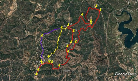
The Aguas Belas valley lies to the north of Silves, a little way east of the huge Barragem do Aarade reservoir. The main route is a ´balloon´ walk, with a long ´tail´. Seven kilometres of the route cover a walk up the valley and back, while the balloon aspect describes an ascent of the hills to the north. There are two alternative finishes to the walk which avoid most of the repetition, but shorten the whole walk a little. There is a bar at the beginning, but no other refreshments. The area feels remote, in spite of being fairly close to civilisation.
Getting to Aguas Belas.
The walk starts from Cafe Terinho, on the old road from Siles to Sao Marcos da Serra. Turn off the A22 motorway at the Lagoa/Silves exit, and follow signs to Silves. Approaching the town, turn left to cross the river Arada, and turn right at the traffic lights. At the next roundabout, take the third exit , signed to Castelo and Cimiterio.. Past the cemetary, turn right at the next roundabout, and follow this road for 3.5k. Cafe Terinho is on the left. Coming along the N124 from the east, bear right5 at the first roundabout on the approach to the town, and then follow as above. Try to park away from the car park, as the place gets very busy at lunchtime.
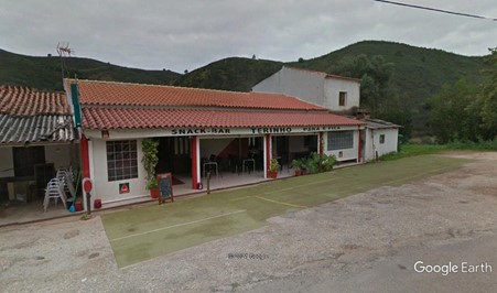
Cafe Terinho
The Walk.
With your back to the cafe, (1) turn left and walk along the road for just over 200m, taking a track on the right leading away from the road at an acute angle. A short distance in, fork left (2), and follow the clear dirt track along the valley. After 400m, the track swings right past a large house, and continues on more or less level ground for another 600m. Come to a fork in he track at a river crossing, and take the right hand. (3). The track swings south for around 300m, and then turns more easterly for another 400m. At another crossing point, take the track furthest left (4). This starts due north, but swings round to northeast, still more or less level, for the next 650m. From here a slightly steeper climb begins as the track winds up for the next 750m to arrive at a junction with a track on the left. (5). This is the end of the ´tail´of the balloon, and on the main route you will return to this spot.
Take the right hand option from here and follow the track first north, then northeast, then almost due north again, undulating now, for 780m. At a fork immediately beyond a small building, stay left. (6)Avoind turns uphill after 150m, and another one after 430m, and climb gently, more or less due north, for another 700m. Now the climb becomes a little more steep as the track curves east, then southeast briefly, then northeast again, to reach a junction with another track after another 830m, level to the left, climbing to the right (7).
Turn right and climb steeply for 200m, then swing left round a hairpin bend to climb for another 240m to reach a high point. Bear right and drop down a littl before starting to climb again. After 840m, swing right round a sharp bend to come to a junction after another 100m (8).Turn sharp left and beging to descend very gently over the next 370m to a junction.(9). Take the left hand track and walk on more or less level ground for a time, before starting to descend. After 400m, the track turns south, soon passing a small barragem on the left. After another 1k, come to a turn to the right, Pass this, and shiortly find another right turn, a much narrower track. (10). (Should this turn out to be too overgrown, retrace your steps to the previous turn and take that - they both lead to the same point.)
The narrower track climbs steeply to a high point and then runs fairly level. The wider track drops for a time, then rises, over about 700m. Each leads to a cross-tracks. (11). From the narrow track, turn left, from the wider one go straight on. The track now runs southwest down a ridge for the next 1.1k. Arrive at another cross tracks (12) and turn left. (This is where the alternative routes diverge.) Over the next 500m, the track goes first south, then east for a time (agnore a track on the right after 190m), then more or less south again to reach a junction after climbing a little once more. (13). Follow the track due south along the ridge for another 660m.
At a junction, (14) take the second right, continuing due south. At a further junction after just over 300m, (15) take the middle track through trees. Head roughly southeast, descending, for around 370m, go round a sharp left hand bend, and come to a junction. You are now back at Point 5. Simply retrace your steps from here to return to the start.
Alternative Route 14.7k From point 12, a cross tracks, go straight ahead for 400m, then turn left at a junction. (12a) Follow the undulating ridge almost due south for 2k, ignoring all turns downhill on either side. At the end of the ridge, (13a) overlooking a small settlement and a barragem below, take a fairly insignificant track on the left and descend steeply to the valley. Join a track in the valley, (14a) which is your outward track, so turn right to retrace your steps to the cafe.
Alternative Route 15.5k From Point 12, a cross tracks, go straight on. Pass a turn to the left after 400m and continue down a ridge for a further 950m, just south of west, before turning southwest and descending steeply to the valley, winding round towards the bottom to reach a track at the valley floor. (13b). Turn left here and walk down the valley road for 1.6k to a point opposite buildings down on the left (14b). Walk past the buildings to find a narrow footpath on the left leading gently down over c100m towards more buildings. Cross the strem bed or stream to reach a track in front of the buildings (15b). This is your outward track, so turn right to retrace your steps to the cafe.
GPS Points. 37/8
| 1 | Turn left | 13 | 23 | 29 | 26 | 28 | 25 | |||
| 2 | Fork left | 13 | 31 | 62 | 26 | 24 | 05 | 280m | ||
| 3 | Fork right | 13 | 45 | 55 | 25 | 52 | 93 | 1k | ||
| 4 | Fork left | 13 | 38 | 92 | 25 | 35 | 82 | 770m | ||
| 5 | Stay right | 14 | 04 | 68 | 25 | 15 | 74 | 1.37k | ||
| 6 | Stay left | 14 | 22 | 39 | 24 | 58 | 83 | 790m | ||
| 7 | Hairpin right | 14 | 56 | 35 | 24 | 24 | 44 | 1.97k | ||
| 8 | Hairpin left | 15 | 19 | 20 | 24 | 03 | 81 | 1.38k | ||
| 9 | Turn left | 15 | 26 | 10 | 24 | 12 | 33 | 380m | ||
| 10 | Turn right | 14 | 59 | 45 | 24 | 24 | 82 | 1.52k | ||
| 11 | Turn left | 15 | 10 | 77 | 24 | 44 | 71 | 730m | ||
| 12 | Turn left | 14 | 52 | 47 | 25 | 15 | 67 | 1.1k | ||
| 13 | Bear right | 14 | 41 | 71 | 25 | 03 | 41 | 510m | ||
| 14 | Straight across | 14 | 21 | 65 | 25 | 09 | 27 | 680m | ||
| 15 | Middle of 3 | 14 | 14 | 53 | 25 | 17 | 23 | 310m | ||
| (5) | Turn right | 14 | 04 | 68 | 25 | 15 | 74 | 400m | ||
| Alt 14.7k | ||||||||||
| 12-12a | Straight ahead | 14 | 48 | 00 | 25 | 30 | 22 | 400m | ||
| 13a | Bear left | 13 | 55 | 89 | 25 | 59 | 72 | 2k | ||
| 14a | Turn right | 13 | 46 | 07 | 25 | 58 | 25 | 320m | ||
| Alt 15.5k | ||||||||||
| 12-13b | Turn left | 14 | 33 | 57 | 26 | 15 | 35 | 1.73k | ||
| 14b | Left on footpath | 13 | 46 | 80 | 26 | 17 | 03 | 1.6k | ||
| 15b | Turn right | 13 | 43 | 63 | 26 | 16 | 22 | 100m |