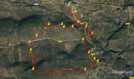
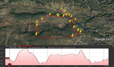
Walk Eighty Seven. Salir - Mesquita circular. 18.6 kilometres
Ascent: 600 metres.
GPS: 37/ 14.24.57 8/ 02 52 39
This relatively easy walk begins at a bar in the small town of Salir. Crossing the valley below the town, it climbs up to the village of Covoes before heading over a hill and descending to the larger settlement of Nave do Barao. From there it climbs again to a broad ridge between two valleys, and continues along it for over 3 kilometres. The route then descends to the hamlet of Mesquita before turning to the high ground once more. Finally comes a descent back into the valley below Salir and a climb back to the town. There is a bar in Nave do Barao, but no other refreshments on the route. There are no water hazards, but one or two short sections might be a little overgrown. Long trousers and secateurs might be worth considering.
Getting to Salir
From the south/west, take the IC1 road from the A22 motorway or the N125 near Albufeira, and travel north to Messines. Follow signs to Alte and Salir, going east on the N124. Pass through Alte and Benafim on this road and arrive at a roundabout, signed right to Salir, with a large statue in the centre. Go up the winding road, past a wide turn to the left, and the bar is on the left after 150 metres. Park on the road. Coming from further west on the 124, say from Silves, simply use the 124 all the way.
From further east, you can take the M525 north from Loulé to Salir. Follow the main road round Salir, pass the (unopened) fire station and petrol station and find the bar on the right after 200 metres.
The Walk.
From the Bar Opcao, (1) cross the road and turn left. After 100m, find a gap on the right with a rough path leading downhill. Follow this down, skirting trees, after around 100m, then resuming the same downward course. After another 260m, curve gently round to the left and walk eastwards to come to an opening leading onto one tarmac lane ahead and another going up to the left. Walk straight ahead and soon come to a junction with a main road. (2). Turn right and walk down the road, keeping well to the side as this is quite busy. Continue across the floor of the valley and begin to climb on the other side. Pass one narow turn to the right, go round the curve and pass a large factory building, then take the lane on the right ascending quite steeply. (3).
Follow this lane as it climbs by stages, first between buildings, then with houses only on the left. Curving round, the lane climbs again to an open space with a a well and wheel on the left. Continue up, rounding a turn to the right and after another 230 metres from this point, emerge onto a narrow tarmac road. (4) Turn right and climb up through the upper part of the hamlet of Covoes. After a couple of sharp twists and turns, the road straightens out and heads westwards out of the hamlet. Pass a cul-de-sac on the left and a final house on the left before the tarmac gives way to a gravel road at the top of the climb.
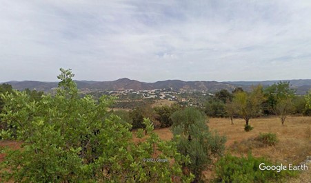
Looking towards Salir from Covoes.
Go forward about 120m from the Covoes boundary sign and by a pylon find a narrow path on the right leading across open ground towards the hill. The path turns left and heads diagonally up across the slope. This path may be rather overgrown, so push or cut your way through, it´s only about 50m. At the top of the slope bear right towards a low wall and walk beside it for a few metres to a corner. Turn left and walk across an open area, keeping about ten metres from the wall. After less than 100m, come to a large bush. Turn right and walk for about 50m due north, to meet a rather indistinct track at right angles. (6) Turn left along this, and after 100m, meet a clearer track and turn left again. Now follow this track as it winds across the open countryside. After around 240m, the surface turns to gravel.
After a further 300m, enter a short section between walls, and then start to descend. After 400m come to a junction with a track on the left. (7). Stay right, and after 250m, come to a tarmac road. Turn left here and follow the road over the brow of a hill and descend. 900m from the brow, find a narrow track leading off downhill on the left (8) and follow it down to the village of Nave do Barao. Walk in front of the first building facing the tarmac road and then go down to the road. See a set of metal barriers over to the right across the road, and walk round the far end to descend a narrow tarmac lane. Wind between the houses at the bottom and emerge onto the valley floor. At a junction with a large blue and white house on the left, go across the tarmac road into an unpaved lane (9).
Follow the lane for just over 500m, then take a turn to the left, descending (10). The lane drops for a time and then starts to climb. Walk for around 1.4k uphill, ignoring any minor turns on either side, to emerge on level ground at a junction with a wider track, with a hill to the right. (11). Turn left. This track wanders across what is really a plateau diving the valley you just left from the next one south. Walk along here for a total of just over 3.4k, taking care not to turn either back over the hill to the north, or down towards the valley to the south. Come at last to a fork in the track, with one arm descending and the other keeping on level ground. Take the latter, to the left, and follow it as it starts to descend towards the hamlet of Mesquita. Where the houses begin, the track becomes a tarmac road. Follow this through the settlement, and take the first, quite sharp, turn to the left. (13). (If you find yourself on a main road, you have gone too far.)
Now walk along the road, more or less on level ground, for 270m, and then take the right at a fork (14). Follow this road past two large properties. After the second one the road ends, and becomes a steeply rising dirt track. As the slope eases a bit, it swings over to the left and then climbs again. Reaching more level ground, the track becomes rather indistinct for a while. Look towards the large pylon ahead, and walk towards it. Past the pylon, walk through a broken wall (15) and find the rather stony track starting to descend. Go down the long hill for almost 900m to arrive at a narrow tarmac road and turn right.(16). At the junction with a wider road, turn right again and walk along to an even wider road. This is the main road between Salir and Loule.
Go straight across and enter a rather neglected track at the top of a long sloping area with evidence of stone terracing. The track heads along the top of the field for a short time before turning downhill. Follow it as it winds down between the rows of stones. Finally follow it through a gap in vegetation to reach the floor of the vallley (17). Turn left and walk along towards a large concrete building. This is the sewage treatment plant (etar) for Salir.. A track skirts it on the left, and comes out past the building on the service road for the etar. Walk along for almost 400m, after which (18) the track turns up to join the main road back into Salir.
. You can walk all the way back to the bar on the road if you wish, though it is rather narow and dangerous in places, without pavement. Alternatively, walk the first 1.2k on the road, joining your outward track at the bridge, then turn off to the left at Point 2 on the narrow lane you used on your way out, and find your way back up the fields to the bar, a further 900m.
For the adventurous, there is a way to avoid quite a stretch of the road at the end of the walk. Do NOT try this unless you are happy with a bit of rock scrambling and off the cuff direction finding! From Point 18, turn right and walk down the lane to a bridge over a stream. Cross over and turn right with the track. A few metres along on the left see a place where people have clearly climbed up the rocks, and follow this trail. Continue on the very narrow footpath up to a wall. See a house ahead with two rows of young trees leading towards it. Walk ahead towards the house for a few metres and then turn left, walking across rough ground. Eventually descend on a narrow footpath into a gully, cross at the bottom and climb up the other side. Work your way eastwards, picking out narrow paths through the scrub. See buildings below to your left, and work your way along, dropping down to join a road at the far end of the buildings. Now turn right and walk to the main road, which you join just after the bridge. This route is marked in yellow on the photo.
GPS Points. 37/8.
| 1 | Bar Opcao | 14 | 24 | 57 | 02 | 52 | 39 | |||
| 2 | Turn right | 14 | 04 | 80 | 02 | 35 | 34 | 900m | ||
| 3 | Turn right | 13 | 49 | 01 | 02 | 29 | 95 | 750m | ||
| 4 | Turn right | 13 | 39 | 66 | 02 | 44 | 68 | 690m | ||
| 5 | Turn right off road | 13 | 39 | 79 | 03 | 06 | 72 | 640m | ||
| 6 | Left onto track | 13 | 45 | 05 | 03 | 11 | 48 | 230m | ||
| 7 | Bear right | 13 | 45 | 88 | 03 | 44 | 08 | 1k | ||
| 8 | Bear left on track | 13 | 24 | 57 | 04 | 15 | 84 | 1.3k | ||
| 9 | Straight across | 13 | 11 | 92 | 04 | 35 | 30 | 650m | ||
| 10 | Turn left | 12 | 55 | 99 | 04 | 32 | 63 | 500m | ||
| 11 | Turn left | 12 | 17 | 82 | 04 | 27 | 52 | 1.39k | ||
| 12 | Fork left | 12 | 13 | 69 | 02 | 17 | 18 | 3.46k | ||
| 13 | Hairpin left | 12 | 29 | 21 | 01 | 44 | 86 | 1k | ||
| 14 | Fork right | 12 | 34 | 01 | 01 | 53 | 21 | 260m | ||
| 15 | Wall gap | 12 | 47 | 23 | 02 | 06 | 87 | 590m | ||
| 16 | Turn right | 13 | 13 | 01 | 02 | 19 | 86 | 900m | ||
| 17 | Turn left | 13 | 25 | 84 | 01 | 54 | 90 | 1.1k | ||
| 18 | Left to main road | 13 | 40 | 06 | 02 | 10 | 83 | 700m | ||
| (2) | Turn left | 14 | 04 | 80 | 02 | 35 | 34 | 1.2k | ||
| End | 900, |