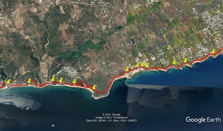
Walk Eighty Six. Salema – Ponta da Piedade (Lagos) 17.4k Ascent: 600m (Extension to Lagos, 2.5k)
GPS: 37/03´56. 23 8/ 49´28.77
This is a linear walk, so you will have to make arrangements to get back to your transport at the end.
The walk follows the southern coastline from the now popular village of Salema, formerly a thriving fishing community, past the tourist resort of Praia da Luz and on to the headland of Ponta de Piedade, on the outskirts of Lagos, one of the largest of the Algarve coastal towns. The walk is a continuation of Walk 61 from Sagres to Salema. The views throughout are stunning, and the walk has the merit of ease of navigation. As long as you keep the ocean on your right, you cannot go far wrong! There are also many opportunities for rest and refreshment along this part of the coast, so you need not carry much food and drink, should you wish to travel light. It should be said that the walk uses cliff paths, and great care needs to be taken not to stray too near the edge. These cliffs are subject to landslides – do obey any instruction boards, and stay on the landward side of any fencing.
Getting to Salema.
Most people will travel from the east. Take the A22 to the Lagos / Vila do Bispo exit, and follow signs to Lagos. At the junction with the N125, turn right towards Sagres. The turn-off for Salema is 14 kilometres from this point. Turn left off the main road to travel into the village, parking in the main square close to the beach.
The Walk.
There are two ways to exit Salema (1) to begin the walk. One is exciting and has just a hint of danger, the other is safe and easier.
The exciting route. This also depends on the state of the tide. If the tide is in and close to the cliffs, you cannot go this way. If the beach is clear, then go onto it and turn left to walk along for around 700m, to where a gap in the cliff (2) allows you to scramble up over rocks onto more level ground above. Find a path heading roughly north-east for around 100m. It then turns westerly and less steeply for a short distance before turning almost due north to head up to the top of the slope, some 140m further on. At the top, join a much wider dirt track and turn right.
The safe and easy route.
Walk to the eastern end of the beach car park, and find a narrow road paved with calcadas (small flat stones), called the Rua dos Pescadores (Fishermen´s Road). Walk up this road for almost 800m, until just before the junction with a wider tarmac road. Find a track on the right heading towards the sea, and walk along it. After about 250m, you will come to the point where the beach route joins this main track.
Now follow the track as it heads first gradually and then more steeply downhill and towards the sea. After about 430m, join a wider dirt road as it describes a U-bend coming up from the valley ahead. Before it swings left, leave the road again to take a path parallel to the beach, and descend to the valley floor. Walk to the beach in front of you and across it, (there are usually quite a few camper-vans here) to find a stream running down to the sea. (3) This is Boca do Rio. Cross this however you can – it can be quite difficult after rain – and climb the hill to the right. You can take the path close to the cliff, or if you prefer, walk a little way inland and find an alternative track on the right. Both lead up onto more level ground after about 300m, to the ruins of a coastal fort (Forte de
Almádena).(4)
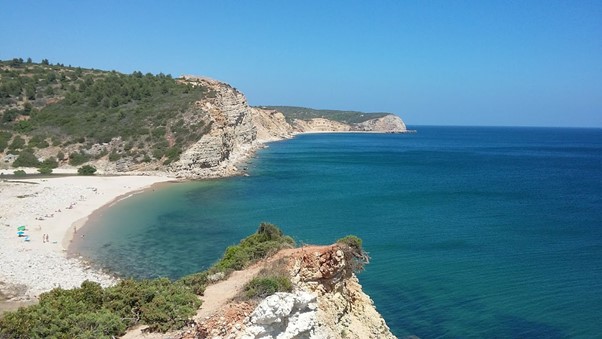
Boca do Rio, looking east. Credit: Atte Ihmaki
Explore here if you wish, then take the narrow path leading off due east from behind the fort, and follow it along the cliff for around 430m, coming down to a track from the left, and facing a large house built right on the clifftop. (5) Follow the path eastwards as it drops below the house, then take the steep track on the right, immediately to the left of the boundary fence, to return to the path along the clifftop. (alternatively, you can follow the road leading from the house to a junction, and then turn right down to the next beach). If you follow the clifftop route, this leads over a rise and then descends steeply to the beach (Cabanas Velhas). Cross the beach where it narrows into the cove, and take the narrow path opposite up onto the next headland. After about 260m, join a wider dirt track.
After a few metres, (6) turn sharp left away from the coast (the right hand only leads down to some old cottages) and follow the track as it cuts across the headland for around 560m, eventually coming back close to the cliff. From here the path stays close to the cliff edge for almost another kilometre. At this point (7), faced with quite a steep hill in front, you can turn left down a path that takes you to a tarmac road. Turning right here will take you into Burgau, but you must turn right again at the first junction to get back onto the route. Choosing to stay on the route over the hill will take you quite steeply downhill towards the village of Burgau, another fishing community being rapidly overtaken by tourism.
About 370m from the top of the hill, come to the end of a tarmac road. (8) Finding your way down to the centre of the village from here is almost a matter of following your nose, but if you take the first right between houses, then turn left along a row, taking a right turn downwards where the lane bends left, you can follow a series of alleyways and steps, heading just south of east, down to a small square close to the beach, with a phone kiosk, some public seating and a couple of restaurants. (Largo dos Pescadores) (9) A good place for a coffee stop, if desired.
To resume, from the square walk north of east up the Rua da Fortaleza, swinging left to reach open ground near the cliff once more. At a fork where the tarmac ends, take the right hand, narrower option and simply follow the cliff path for 1k to point (11), where a junction would take you to houses on the left, and on again for a further 450m to point (12). Here again is quite a steep hill, which you can either go over or round to the left, returning to the cliff path at the other side. A further 320m along the cliff path, you have the option to continue close to the cliff or to use a slightly wider track a little way inland. The two merge after a further 500m or so.
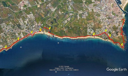
You can cut off the next small headland by staying left at the next junction, (13) leaving a grassy area to the right. After this, the track simply heads east towards Praia da Luz, which can be seen ahead. Stay as close to the sea at the tracks allow, and eventually come into a wide dirt road running parallel to the shore, with houses to the left. This becomes a tarmac surface as the Rua da Calheta, which finally opens out into the Largo da Republica, with the Anglican Church on the right. (15) Here again is an ideal place either to terminate your walk or to eat and drink prior to carrying on to Ponta da Piedade.
Turn right off the Largo, past the church and round the bend onto the sea front of Praia da Luz. Either walk across the beach or round by road, staying as close to the beach as possible. Take the last available road before the cliffs, a narrow calcada-paved road heading north-east.(16) This ends at the gate of a large very modern villa after around 450m. Turn right into a circular open space and take the left-hand track heading south-east, level at first but then climbing. After 100m, where the main track turns, stay on a narrower path straight ahead. After a further 200m, the track widens and turns right, towards the sea (17). Now the path becomes a simple cliff-top walk again, for 2.8k, until it reaches the small settlement of Porto de Mós. (18). Here a detour is needed, as a cliff fall has blocked the way ahead on the path.
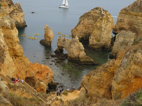
Rock formations near Luz, woth people, boat and canoes! Credit: Johan van Geel.
At the car park in Porto de Mos, take the road heading inland and follow it for around 650m to a roundabout. Turn right here and follow the road for 400m back towards the sea. Where the road runs out, (20), turn right onto a footpath, then left after a few metres, and shortly afterward take the right hand option at two forks in the track to continue the walk close to the cliff tops.
From here simply follow the pathways to Ponta de Piedade, around a kilometre away. Choose your own path from those on offer, to suit your comfort in relation to the cliff edge, but do respect any warning notices. As you approach the end, there are a couple of tracks on the left (21) that will take you up on to the road near to the lighthouse.
If you intend to carry on walking into Lagos, you can walk right round the front of the lighthouse compound and continue on footpaths for another 2+ kilometres to reach the main road into town just above the bay. This extra section is not included in the distance calculations for the walk, but it can be done without any additional risk.
GPS Points. 37/8
| 1 | Salema | 03 | 56 | 31 | 49 | 28 | 70 | |||
| 2 | Turn off beach | 03 | 57 | 76 | 49 | 00 | 06 | 740m | ||
| 3 | Boca do Rio | 04 | 01 | 24 | 48 | 28 | 20 | 1.14k | ||
| 4 | Fort | 04 | 00 | 23 | 48 | 16 | 81 | 340m | ||
| 5 | Large house | 03 | 59 | 48 | 47 | 58 | 59 | 480m | ||
| 6 | Alternative junction | 03 | 53 | 98 | 47 | 31 | 68 | 720m | ||
| 7 | Sight of Burgau | 04 | 15 | 06 | 46 | 47 | 64 | 1.53k | ||
| 8 | Edge of Burgau | 04 | 20 | 22 | 46 | 53 | 58 | 470m | ||
| 9 | Burgau centre | 04 | 21 | 40 | 46 | 26 | 66 | 280m | ||
| 10 | Fork after Burgau | 04 | 20 | 19 | 46 | 20 | 22 | 240m | ||
| 11 | Fork to houses | 04 | 24 | 90 | 45 | 43 | 35 | 990m | ||
| 12 | In front of hill | 04 | 27 | 32 | 45 | 28 | 13 | 450m | ||
| 13 | Headland cutoff | 04 | 38 | 69 | 44 | 48 | 82 | 1.13k | ||
| 14 | Before Praia da Luz | 04 | 54 | 90 | 44 | 21 | 11 | 910m | ||
| 15 | Luz Centre | 05 | 08 | 82 | 43 | 50 | 28 | 890m | ||
| 16 | Exit Luz beach | 05 | 13 | 86 | 43 | 29 | 56 | 640m | ||
| 17 | Turn back to cliff | 05 | 17 | 26 | 43 | 06 | 91 | 730m | ||
| 18 | Porto de Mos | 05 | 09 | 44 | 41 | 20 | 85 | 2.94k | ||
| 19 | Roundabout | 05 | 17 | 26 | 40 | 51 | 67 | 640m | ||
| 20 | Back to sea | 05 | 07 | 57 | 40 | 41 | 42 | 400m | ||
| 21 | Left or straight on | 04 | 51 | 47 | 40 | 13 | 37 | 1k | ||
| (Lagos) | 2.5k |