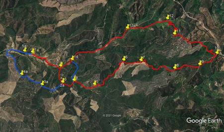
Walk Eighty Five. Romeiras Circular. 14.2k, with extension of 3.5k
Ascent: Approx 700m. GPS: 37/15 56 65 8/42 02 42
Romeiras is one of the more remote starting points in this series, so an early start is recommended. The scattered settlement lies in a valley to the north of Lagos, the most westerly large town in the Algarve. There is little here but wild countryside, a few houses and a very welcoming Cafe Pacheco, the start of the walk. The walk itelf consists of a long outward climb followed by an equally long return descent. There is an extra loop with some more climbing, which gives trong walkers the satisfaction of a good distance for the amount of car travel involved.
Getting to Romeiras (Cafe Pacheco)
From the East. Exit the A22 motorway at the junction for Odiaxere. Follow signs to Odiaxere, which taeke you onto the EN125. In the centre of Odiaxere, turn right at the traffic lights. The road is signed, rather unhelpfully round the corner to Bravura (brown sign) This is the Barragem de Bravura, a large reservoir that lies on the route. Follow this road, signed to the Barragem at intervals. You will pass close to a couple of the árms´of the reservoir as you travel north. Stay on this same road past Bravura, and at a T junction follow signs to Monchique and Marmalete (there is a wooden sign to Romeiras here too, but not so visible). Continue on past a narrow road signed to Tres Figos, wind through the valley and come to the Romeiras bounday sign. Go past the small cluster of buildings, and a few hundred metres further on see Cafe Pacheco on the right.
The Walk
With your back to the café, (1) turn right and walk along the road for around 420m, to the junction with a track on the right. Turn onto this track and walk on more or less level ground for a further 500m, passing a couple of buildings on your left. Come to a junction with a track heading uphill on the right, (2) and turn onto it. It climbs steadily at first, south-easterly, then more steeply, and more or less due east, passing two farm tracks on the left. Reach a ridge after 490m (3) and cross the ridge track, descending quite steeply into a valley, reaching a wide track at the floor after another 380m (4)
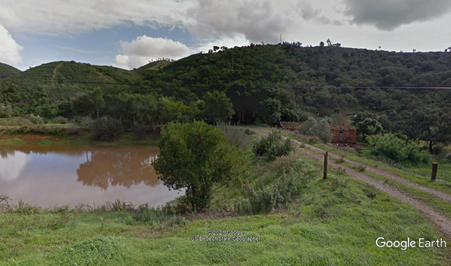
Barragem and hills near the start/finish of the walk.
Turn left and walk for a few metres before swinging right onto a track which starts to climb again, heading north-east. The climb is steady rather than steep, passing several tracks leading off left an
d right. See old buildings up on the left and pass a long building close to the track before rounding a hill and coming to a small cluster of old houses, some ruined. (5) (about 700m from point 4). Continue on the main track, ignoring a fork to the right down to the valley, climbing all the while and passing a renovated house down on the right. Round a left-hand bend, ignore a track forking off left and continue to climb, now generally west of north, to reach another ridge after a couple of hairpin bends, 1.3k from point 5 (6)
Now follow the ridge as it trends just east of north to a fork after around 500m (7). Take the right hand track and follow it on an undulating course just below the ridge for c1.2k to another junction, with a clear track coming up from the right. (8) On the way, pass a small barragem down in a valley on the left, and a slightly larger one later on the right. Stay on the same course, following the track fo
r a further 260m to join another track coming in from the right. Now continue in the same undulating fashion for another 500m to yet another junction with a track from the right. (9). Again continue in the same direction for another c600m, more or less on level ground, to find a track on the left leading off south-westwards. (10).
Turn on to this track and follow it as it begins to descend. Go round a sharp left hand turn in a shallow valley, pass a ruin on the right and a small barrage on the left before coming to a junction with another track after c630m. Turn right along a short straight bit of track and then left at the next junction. The route runs just west of south and then due south to reach a junction after c280m. Bear right here and very soon take the middle line at a three-way. After 200m go straight across at a cross-tracks. After 100m bear left and a further 50m further on bear right. After another 120m join a track coming in from the right, and go due south for a further 120m to a junction. (11)
Swing round to the right here and follow the track as it pursues a convoluted, steeply descending track to the valley floor, a distance of c990m. After 250m, make a hairpin turn to the right, and do the same again in front of an old building after a further 430m. Finally reach a wide valley track after crossing a stream or stream bed. (12). Now turn left and walk straight down this wide track for 1.19k to reach point (13). Keep to the main track down the valley and continue for a further 2.1k to reach a junction at point (14).(This is also Point 1a, the start of the extra loop, see below). Turn right and walk for another 370m. You are now back at Point 2. Turn right and walk down to the main road (550m), then turn left to cover the last 420m to the cafe.
Extra Loop.
From Point From Point 14/1a, turn left and walk along the valley for 700m. At the end, pass a small farm on the right, curve left and then right at the junction to return to Point 4. Turn right and climb the 370m back up to Point 3/2a.. (2a) Turn left and walk east of south over a rise and down to a junction, passing a barragem on the right. see a small circular building ahead, and walk round it to take a track heading southwest. After 220m, come to a T junction and turn right (3a). Turn right and climb again to reach a ridge, swinging left to walk along this undulating path south-westerly for around 740m. (4a). Turn right at the junction and continue down the ridge to the valley floor, turning right with the track to reach the tarmac road after just over 1k.(5a). Bear right at the road to walk back to the cafe Pacheco, 650m along.
GPS Points. 37/8
| 1 | Cafe Pacheco. | 15 | 56 | 65 | 42 | 02 | 42 | |||
| 2 | Turn off road right | 16 | 16 | 93 | 41 | 36 | 39 | 950m | ||
| 3 | Straight across | 16 | 13 | 78 | 41 | 18 | 33 | 490m | ||
| 4 | Left and right | 16 | 23 | 48 | 41 | 15 | 37 | 380m | ||
| 5 | Buildings | 16 | 39 | 93 | 41 | 03 | 21 | 700m | ||
| 6 | Straight at junction | 17 | 11 | 89 | 41 | 08 | 87 | 1.3km | ||
| 7 | Fork left | 17 | 26 | 17 | 40 | 54 | 08 | 500m | ||
| 8 | Straight on north | 17 | 50 | 87 | 40 | 49 | 44 | 1.2km | ||
| 9 | Straight on | 18 | 06 | 78 | 40 | 42 | 83 | 760m | ||
| 10 | Turn left | 18 | 29 | 81 | 40 | 48 | 70 | 590m | ||
| 11 | Hairpin right | 18 | 01 | 44 | 41 | 24 | 92 | 960m | ||
| 12 | Road. Turn left | 18 | 01 | 53 | 41 | 43 | 98 | 990m | ||
| 13 | Fork left | 17 | 25 | 19 | 41 | 49 | 99 | 1.19k | ||
| 14 | Turn right | 16 | 31 | 28 | 41 | 32 | 35 | 2.1k | ||
| End main route | 1.32k | |||||||||
| 1a | Left off the road | 16 | 31 | 28 | 41 | 32 | 35 | |||
| 2a | Stay left | 16 | 13 | 78 | 41 | 18 | 33 | 1.1k | ||
| 3a | Turn right | 15 | 55 | 97 | 41 | 23 | 92 | 670m | ||
| 4a | Turn right | 15 | 41 | 92 | 41 | 42 | 34 | 730m | ||
| 5a | Bear right | 15 | 50 | 28 | 42 | 06 | 99 | 900m | ||
| End | 670m |
Note: On this photo, north is to the right.