
Walk Seventy Seven. Foz de Banho - Picota Circular. 16.3 kilometres
Ascent: 940 metres.
GPS.: 37/ 16 45 18 8/ 33 13 29
The Monchique range is the highest in the Algarve, and as such affords some of the toughest walks and the best views. There are two main peaks, Foia being the highest, and Picota slightly lower. However, while Foia summit is covered in ugly buildings and communications towers, Picota boasts only a firewatch tower, and is thus a far more pleasant climax to a walk. The approach on this route is somewhat easier than some others, but no ascent of Picota can be taken too lightly. It starts from a popular cafe-restaurant just outside the spa village of Caldas de Monchique, on the road between Portimao and Monchique town, and heads up in an almost unbroken climb to the summit, followed by an equally unrelenting descent. Conditions on Picota summit can be cold and windy on the best of days, so do go prepared.
Getting to Foz de Banho.
Leave the A22 motorway at Portimao, and turn away from the city towards Monchique on the EN266. Follow signs to Monchique through Porto de Lagos and Rasmalho. After 13k, look to see a very large hotel complex rising up on the right, and very soon afterwards find the Foz de Banho restaurant and gift shop on the left. It is best to go up and round the roundabout rather than cross the road to the car park.
The Walk.
Cross the road from the restaurant, (1) and turn right. Walk a short distance and fork left, up into the grounds of the hotel, which is a spa resort. Follow the tarmac round for just over 300m, and turn sharp left where a road goes off to the right. Walk along to another sharp bend, this time to the right, and start to climb on what is now a dirt track, heading just west of north. (2). Avoid one fork to the left and another to the right, and after 400m, take the right at another fork. After 360m come to a tarmac surface. Turn right and almost immediately left off the road onto another track.(3) Follow this for almost 1.5k, as it climbs steadily. Pass a couple of water storage tanks up on the right, and walk through open country. Come to an area of cultivated terraces with a cluster of buildings. This is the hamlet of Barranco do Banho. Pass between the terraces on the path, to reach a T junction with a tarmac road. (4)
Turn right and at a fork stay left. After another 100m, turn left up a narrow path climbing quite steeply. After around 170m, the path turns sharply right and a short time later widens out a little and heads off in a straight line east of north. After 330m, pass to the left of a couple of large houses, and continue in the same direction through the trees to a junction with two more water tanks in front of you. (5). Turn right. After 180m, cross a tarmac road into a wide dirt track, heading southeast. 260m further on turn sharp left in front of a small building, and after another 170m, turn right at a junction (6)
Over the next 1.4k, the track heads first more or less due east, then southeast for a longer time to reach terraced fields and a farm, (7) where the wide track ends. Walk round between the small farm building on the left and the farmhouse on the right, turning left to pick up the track, narrowed to a footpath. At a fork above another terraced valley, 230m from the farm, take the left hand track.(8). This wanders up the hillside for a further 850m before crossing another track (9).From here you can see the top of Picota away to the right. Simply follow the track for the remaining 500m, scrambling up the last rocky section to the summit. (10)
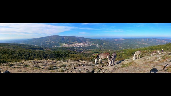
Monchique town from Picota
To return, walk back down to the cross.tracks at point 9 and turn left. Follow this track as it heads first easterly, then turns south and finalyl southwest, over the next 1k. Pass the junction with point 8, and after another 100m, turn left on a narrow path heading due south, (11) with terraces and buildings visible on both sides. The path kinks to the right after 220m, to pass below the terraces, then turns south again for another 220m, before a sharp turn left takes you down to a junction with a tarmac road (12). Turn right here and walk for 500m to find a hairpin turn to the left. (13) Turn here and, ignoring an immediate turn to the right, follow this wide track eastwards as it runs above a cluster of buildings. The track eventually turns south and then southwest. 1.75k from point 13 come to a junction with a tarmac road and bear right along it. (14)
200m along, turn off the road to the left, and start to walk down a long ridge, heading more or less due south. After 1.7k, take the right hand at a fork (15). Pass three tracks leading down into the valley on the right, and take the fourth one, a sharp right hand turn, after almost 700m.(16). Follow the track into the valley. After 170m, it turns to the right. Follow it for a short distance, and then turn off the path to drop down over rough ground to reach a track heading southwest, less than a hundred metres away. Follow this down. After around 600m, leave a small dam and a building to the right and continue on the same line down to a farm after another 220m..
Turn right at the farm and follow the track for 260m to a junction. Turn right and at a cross tracks very soon afterwards (17), stop and consider. Turning left will take you down to the main road, where a right turn will take you back to the start after another 1.4k. The road is busy, so if you would prefer to stay off it for as long as possible, go straight across. After 190m, turn right uphill. The track soon turns to run parallel with the main road. After 270m, stay left at a fork (18), and after a further 460m, (19) turn left and drop down to the main road. Turn right along the road, to reach the cafe after 500m.
GPS Points. (37/8)
| 1 | Foz | 16 | 45 | 18 | 33 | 13 | 29 | |||
| 2 | Turn Right | 16 | 49 | 33 | 33 | 08 | 43 | 550m | ||
| 3 | Fork right | 17 | 01 | 03 | 33 | 09 | 88 | 390m | ||
| 4 | Turn right | 17 | 46 | 54 | 33 | 13 | 83 | 1.9k | ||
| 5 | Turn right | 18 | 04 | 81 | 33 | 16 | 68 | 820m | ||
| 6 | Turn right | 18 | 10 | 73 | 32 | 55 | 99 | 600m | ||
| 7 | Bear left | 18 | 01 | 75 | 32 | 14 | 23 | 1.16k | ||
| 8 | Fork left | 18 | 06 | 90 | 32 | 07 | 86 | 230m | ||
| 9 | Straight on | 18 | 18 | 44 | 32 | 08 | 39 | 850m | ||
| 10 | Summit | 18 | 27 | 78 | 31 | 54 | 24 | 500m | ||
| 11 | Turn left | 18 | 05 | 30 | 32 | 09 | 95 | 1.5k | ||
| 12 | Turn right | 17 | 52 | 49 | 32 | 03 | 45 | 640m | ||
| 13 | Turn left | 17 | 41 | 76 | 32 | 17 | 37 | 500m | ||
| 14 | Turn right | 17 | 33 | 13 | 31 | 43 | 33 | 1.75k | ||
| 15 | Fork right | 16 | 42 | 22 | 32 | 01 | 74 | 1.7k | ||
| 16 | Turn right | 16 | 23 | 35 | 32 | 12 | 06 | 700m | ||
| 17 | Straight on | 16 | 21 | 04 | 32 | 50 | 84 | 1.37k | ||
| 18 | Stay left | 16 | 32 | 28 | 32 | 54 | 60 | 490m | ||
| 19 | Turn left | 16 | 46 | 35 | 32 | 51 | 54 | 460m | ||
| End | 670m |
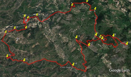
NOTE. On this photo, north is right.