Walk Thirty Seven. Fonte Filipe Circular. 16.5 kilometres. Ascent: 705 metres.
There are several well known Fontes, or public wells, in the area between Sao Bras de Alportel and Querenca, and some make excellent picnic spots. Fonte Filipe, close to the village of Amendoeira, is one such place. It also serves as the start point for several walks, and this is one of them. Although relatively short by the standards of this site, it is quite demanding, in particular because of the amount of climb involved, and especially one short section. The reward is in the views, which are spectacular. There are two or three water crossings on the route which could be tricky after heavy rain. Unusually, there is no bar at the start point, but there is one close by in Amendoeira.
Getting to Fonte Filipe.
From Loule (west )
Leave the A22 motorway at the Loule Centro exit and follow signs to Sao Bras. This takes you round a peculiar ´banjo´near the fire station. From here, go through three roundabouts. After the third one, travel a few hundred metres to see a large sports centre on the left. Turn left at the roundabout immediately afterwards and follow this road for around 3.5k, through Clareanes. See a sharp turn to the right signed Carvalhal and Amendoeira, take this and drive 2.7k to a crossroads in Amendoeira. Go straight across and follow the road down to the Fonte, just over 1k. Park in the car park.
From the east. (Sao Bras)
Take the N270 Loule road from the town (or follow the bypass if you are coming from further east) . Just after the end of the bypass, turn right uphill to Sao Romao. Follow the winding road past the small church and up to a junction with a turn to the left and a cafe on the right. Turn left and follow this road for 3.6 k to Amendoeira. Look for the turn to Fonte Filipe on the right and follow the road down to it.
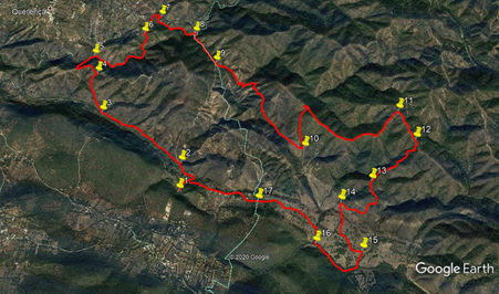
The Walk.
From the car park, (1), walk onto the road and turn right. After 140m, leave the tarmac by taking a track on the left as the road swings right. 100m on, come to a junction and turn left. 270m further on, come to another junction (2), and bear left to continue in the valley close to the watercourse on the left. Continue on more or less level ground for just over 1.2k, to a junction with a track coming in from the left (3). Stay on the same line as the track now begins to climb quite steeply over the next 600m, to reach a cross-tracks (4). Turn left here and climb less steeply to reach a high point after another 140m.
Swing left at the summit and descend gently for 180m, then turn right at a junction and descend more steeply, swinging right quite soon. Follow the track down into a valley, with a tarmac road visible down to the left. Meet another track at the bottom of the descent, (5) with the road very close by. Cross this track and turn sharp right to follow a track in the valley, heading southeasterly. After 300m, the track turns northeast for 270m, then east for 170m, rising imperceptibly over this distance, before turning north for another 560m, rising more steeply towards the end. Emerge onto a hard surfaced road, with buildings over to the left, (6) and turn right to walk along to join a main road, close to the settlement of Corte Garcia.
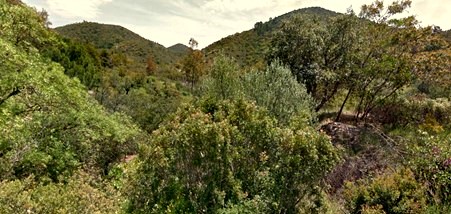
Cerro Negro from near Point 7.
Turn right and walk down the road, rounding a sharpish right hand bend, over the next 300m. Round the bend find a turn off to the right (7) and follow the track down into the valley. Continue alongside the watercourse (and at some points walking in the stream bed) for just over 700m. Climb briefly to a junction (8), turn right and descend to cross the stream. Now follow the track on a long climb, with the steep side of Cerro Negro looming on the right. After 550m, come to the top of the climb (9) and take the middle one of three tracks, heading off southeast. It descends first into quite a deep valley, turns sharp left into the bottom, then swings sharply round to the right and climbs again. Another sharp turn to the left is followed by a longish straight steep section before the gradient eases and the general southeast trend is resumed.
Reach a high point around 500m from the valley bottom, and start to descend. For the first 800+ metres, the track sits in a fairly narrow valley but then, cresting a short rise, the view opens out. Soon after getting this wide vista, find a track on the left, heading almost due north (10). This climbs very steeply over the next 500m, to reach a ridge. At the top, turn through a hairpin to the right, to follow the ridge over the next 1.4k. Starting out on an undulating course, it rises steeply again towards the end of this section. Come to a junction at this new summit (11) and turn right, heading south southeast and starting to descend. After 400m, bear right at a cross-tracks (12) and continue to descend, due south.
The track soon turns southwesterly and continues to descend, first below the ridge line, then on it, for a further 800m. At a junction with a minor track, (13), it turns due south for a time, before winding round as it descends, then turning westerly for a short time. Come to a hairpin turn to the left, about 800m from Point 13. (14). Avoid a turn to the right immediately after the bend, and follow the track due south, rather less distinct than before, across the valley, to reach a T junction with another track after 360m. Turn left here.
After 320m turn right (15) and after another 200m cross a stream and turn right on a track on the farther side. After 600m, cross the stream again (16), and walk across a field with bushes on the right. Turn left after 180m, and follow the track heading roughly northwest. After almost 800m, a municipal boundary is crossed, and the track becomes a tarmac road. (17) Follow the road on through the hamlet of Almarjao, and on until it turns 90 degrees left and very soon after reaches the car park at Fonte Filipe and the end of the walk.
| 1 | Fonte Filipe | 10 | 50 | 89 | 57 | 47 | 04 | |||
| 2 | Bear left | 11 | 01 | 88 | 57 | 49 | 24 | 540m | ||
| 3 | Straight on | 11 | 16 | 86 | 58 | 34 | 13 | 1.2k | ||
| 4 | Turn left | 11 | 32 | 43 | 58 | 41 | 44 | 600m | ||
| 5 | Across and right | 11 | 40 | 46 | 58 | 46 | 54 | 630m | ||
| 6 | Turn right | 11 | 53 | 51 | 58 | 23 | 26 | 1.13k | ||
| 7 | Turn right | 12 | 02 | 87 | 58 | 17 | 02 | 430m | ||
| 8 | Turn right | 11 | 57 | 64 | 57 | 57 | 07 | 720m | ||
| 9 | Middle of 3 | 11 | 44 | 91 | 57 | 42 | 58 | 560m | ||
| 10 | Turn left | 11 | 15 | 17 | 56 | 51 | 66 | 1.9k | ||
| 11 | Turn right | 11 | 34 | 68 | 56 | 10 | 77 | 2k | ||
| 12 | Bear right | 11 | 24 | 86 | 56 | 00 | 99 | 400m | ||
| 13 | Turn left | 11 | 06 | 91 | 56 | 18 | 61 | 800m | ||
| 14 | Turn left | 10 | 57 | 32 | 56 | 30 | 84 | 800m | ||
| 15 | Turn right | 10 | 41 | 28 | 56 | 18 | 37 | 690m | ||
| 16 | Turn right | 10 | 40 | 74 | 56 | 39 | 72 | 770m | ||
| 17 | Straight on | 10 | 52 | 37 | 57 | 09 | 22 | 1k | ||
| End | 1k |