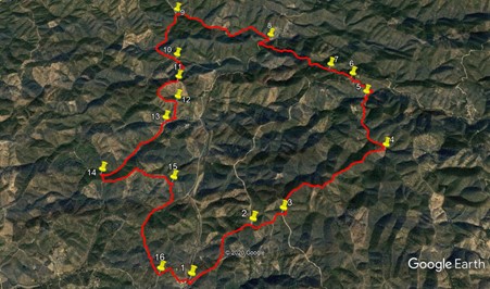
Walk Fifty Five. Portela do Barranco (1) 16.6k Ascent: 670m
GPS: 37/ 16.57.03 8/ 01.34.02
Portela do Barranco is a tiny hamlet in the hills north of the small market town of Salir. There are half a dozen houses and a bar/restaurant, set in the midst of wild countryside with only scattered farms and half deserted hamlets over many square kilometres. The walk takes you on an undulating but never extreme tour round this area, and in the course of a day you may not see another soul. The views are to die for, and the walking good underfoot. There are a couple of stream crossings which may need to be paddled through. I am again indebted to Frank McEwan for devising and leading this walk.
Getting to Portela do Barranco.
First get to Salir: from the west along the N124 from Silves/Messines, via Alte and Benafim (or from the A2 or IC1 at Messines onto the N124), from the south leaving the A22 at Loule Centro and following signs to Sao Bras and then Salir, and from the east leaving the A22 at the Sao Bras exit, then following the N2 via Sao Bras and up to Barranco do Velho, turning left at Barranco for Salir.
The turn for Portela do Barranco is about 600m east of the roundabout on the N124, just north of Salir. The road is signed also to California (!) and various other places. Follow this road up into the hills. Reaching a junction on a saddle, turn right downhill (the other direction is signed to Freixo Seco), and follow the road into the valley and up the winding route to the hamlet. Turn right after the first building, and park round the corner on the left. You will see the bar on the right as you go through.
The Walk.
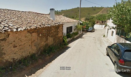
Portela do Barranco. The bar is down on the left
From your car, walk round the corner to the left, past the road sign to Salir, and find a wooden finger post with `Circuito` on it, pointing uphill on a wide dirt road. (1). Follow this road for 1.24k, fairly steeply uphill to start, then less so. Pass one obvious turn to the right, and come to a fork. (2). Turn right here to face east. Pass a turn to the right after 310m as the track turns northwards. Just round the bend after another 210m, find a much narrower dirt track leading off on the left (3), and follow it as it very soon turns due north and runs for 190m to a fork. Take the right hand here and head northeast along a ridge, on more or less level ground at first, and then descending into a valley, over the next 1.9k. Near the bottom of the descent, the track swings round to the left to hit the valley floor (4).
Turn left.
Now facing northwest (and then turning more due north), follow the valley, descending very gradually, for the next 1.1k. Towards the end of the section, see a wall on the right with evidence of some cultivation, and follow the track as it turns sharply left through trees to reach a junction. (5). Take the right hand of two tracks heading roughly northeast and walk, still more or less on level ground, for 190m. Find a much less obvious track, looking slightly overgrown, heading uphill on the left, and follow it for just over 300m, to reach a clear track among buildings, mainly ruins. Turn left and walk round the corner past ruins on the left, and take the right hand at a fork (6). Descend a little and then climb a little over the next 400m, heading northwest, to reach a turn to the right towards another ruined settlement. (7).
Carry straight on here and after another 420m, stay left at a fork with a narrower track. Continue on the northwesterly line walking through trees for much of the time, descending gradually at first then more steeply towards the end, for 900m, to come down to a junction with a wide dirt road. Turn right and walk for 180m. Take the second track on the left (8), heading again northwest in a valley. After 370m, the track turns southwest, and a further 370m later goes due north for a short distance, before resuming the northwesterly trend over the next 1k. Come up to a tarmac road (9), turn left and walk along it for 1.1k. Coming round a short right-hand curve, see a small area of cleared ground on the right, with a tractor track leading off it. (10) Just to the left of that, see a rather overgrown footpath heading off at an acute angle to the road, and follow this as it beings to climb gradually and then a little more steeply into trees.
After 220m, come to a junction with a similar track coming in from the left, and turn right. Heading first southwest and then due south, the track climbs steadily more steeply over the next 300m, to a T junction with a more obvious track (11) . Turn right, and now on a ridge, follow the track round a wide semicircle for just over 700m, to a point due south of point 11. (12). Here find a track heading due south downhill from the ridge, ending at a junction in a valley after 270m. Turn right to walk for 200m, past an old well by a stream, to reach a fork (13) and take the left hand option. The track continues in the valley, rising imperceptibly at first, but towards the end of 1.25k, it becomes quite steep. come to a junction (14) and turn left, and then after 120m, turn left again.
This track starts off almost due east, then turns northeastwards, rising steadily, then turns southeast, rises to a summit and then begins to descend, after just over 600m. 470m after the summit come to a track on the right heading due south (15) and follow it down over 270m to another junction. Turn right. The track now follows a very wide left hand curve, first southwest, (stream crossing roun about here), then due south, and finally heading towards southeast, over the next 1.3k. Rising very gently at first, the climb becomes steeper towards the second half of the section, ending at a junction with a tarmac road. (16). Turn left here to walk just under 500m back to the start
.
| 1 | Portela de B | 16 | 58 | 40 | 01 | 33 | 66 | |||
| 2 | Stay right | 17 | 18 | 93 | 00 | 59 | 06 | 1.25k | ||
| 3 | Turn left | 17 | 22 | 89 | 00 | 42 | 05 | 510m | ||
| 4 | Bear left | 17 | 49 | 75 | 59 | 38 | 59 | 2.11k | ||
| 5 | Turn right | 18 | 17 | 41 | 59 | 44 | 73 | 1.10 | ||
| 6 | Fork right | 18 | 26 | 51 | 59 | 52 | 23 | 550m | ||
| 7 | Straight on | 18 | 32 | 10 | 00 | 39 | 88 | 1.53 | ||
| 8 | Turn left | 18 | 52 | 12 | 00 | 39 | 88 | 1.53k | ||
| 9 | Turn left | 19 | 09 | 54 | 01 | 39 | 30 | 1.80k | ||
| 10 | Fork right | 18 | 43 | 32 | 01 | 39 | 72 | 1.1k | ||
| 11 | Turn right | 18 | 30 | 03 | 01 | 38 | 53 | 520m | ||
| 12 | Turn right | 18 | 19 | 61 | 01 | 39 | 22 | 710m | ||
| 13 | Fork left | 18 | 09 | 73 | 01 | 46 | 99 | 450m | ||
| 14 | Turn left | 17 | 45 | 77 | 02 | 22 | 99 | 1.26k | ||
| 15 | Turn right | 17 | 40 | 21 | 01 | 42 | 37 | 1.19k | ||
| 16 | Turn left | 17 | 00 | 77 | 01 | 49 | 46 | 1.53k | ||
| End | 510m |