Walk Three. Aguas Frias Circular 18k Ascent: 780m
This is an immensely rewarding walk. The scenery is excellent, the walk is largely through open country with few houses, and the views spectacular. The near 800 metres of ascent are gained without any extreme climbs. Aguas Frias is not the easiest place to get to, but therein lies its attraction for those who like to walk away from the crowds. Starting from the bar in the small settlement, which only received a tarmac road a few short years ago, the walk soon leaves any habitation behind and meanders through empty valleys and over hills with only the relics of earlier times dotted here and there. Some sleepy farms – and some canine welcoming committees – are passed, but these soon give way once again to total peace. I am indebted to Frank McEwan for devising and leading this walk.
Getting to Aguas Frias
From the West.
Use the N124 or the A22 and IC1 to travel to Messines. Follow the 124 to the roundabout leading to the A2 motorway, and take the third road off, signed to Messines. At the end of the long straight, turn right, signed on the right to Fonte Joao Luis. Follow this road under the motorway and drive for 8k to Azinhal. Take the second turning to Aguas Frias and follow this road all the way to the hamlet. The Café Aguas Frias is in front of you on the left.
From the East and South.
Leave the A22 at junction Loule Centro and then follow signs to Sao Bras. Turn off this road - the Loule northern bypass - at the Rotunda de Salir, taking the third road off, towards Salir. Follow this all the way to Salir, passing through the traffic lights at Tor on the way. Stay on the same road past the town, and descend to a roundabout on the N124 with a large concrete statue of a lizard. Turn left here are drive for just over 1k, then turn right\, signed to Malhao, Cortinhola etc. Follow this road over the crest between two valleys and then along the next valley through a couple of settlements. At Cortinhola, turn left at the T junction and drive on to Azinhal. There turn left, signed to Aguas Frias. Follow the road through to the hamlet, finding the Bar facing you on the left.
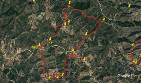
The Walk.
With your back to the bar, (1) turn left and walk along the road for almost 900m. Round a sharp bend with a farm on the right, see a road on the right, and very shortly after, a turn downhill on a track on the left (2). Take this track and follow it as it descends and crosses a stream at a ford. (If the stream is running high after rain, it is better to cross the stream by the road bridge just before the farm. Then turn right on a track, following the stream to link up with the walk route by the ford.)
Follow the track from the ford northwest for 200m, go straight across at a cross tracks and turn southwest, to follow an undulating track for around 350m. Walk round a small semicircle on the track, ignore a track going off south-east on the left, and continue in the same direction, beginning to climb. Over the next 900m, the climb is gentle, following the valley track. From this point, the gradient becomes steeper, and the track winds. Pass a track on the left after 240m, and join another coming from the left after another 220m. (3) This is the summit of the climb.
120m further on, take the left at a fork, and begin to descend, at first very gently. After around 470m, the track turns from a generally westward course to southeast, and the gradient steepens. Another 350m brings you to the foot of the descent. (4) Swing round to the right, and now facing northwest, continue along the track, descending very gently, to pass a small cluster of buildings on the left after 460m. The track curves round to face due south now, and after another 320m, come to a junction with a track on the right. (5) Take this turn and climb steeply to pass the hamlet of Zebro de Cima. At a cross-tracks just after the houses, bear right and continue to climb. 270m after this turn, come to a junction at the top of the climb, with buildings opposite.
Stay right here, and follow the track more or less due north for 1.8k, descending all the time. After this point, ignoring turns to the right, swing round to face due south and come to Zebro de Baixo. At a junction with a wide dirt road, (6) turn right, and walk on more or less level ground for around 850m. Come to a junction with a track on the left and take it, starting to climb quite steeply once more. (7) . Fork left after 320m, and cross over from the Algarve into the Alentejo, the next province north. From this point, the walk criss-crosses the boundary, and follows it for a while.
The track heads north for a time, then curves round to the east, before suddenly turning due south to reach a track junction 1100m from the boundary line. Take the first left here, and after a short further climb, take the second left at the next junction, which marks the summit (for the time being) (8). From here, descend fairly gently to another junction after 330m. (9) Just round the corner to the right is a ruined hamlet, with excellent views, good for a lunch break!
If lunch is not desired, turn left and continue to descend for a while. After 750m, the track starts to climb again. The ascent on the right looks rather intimidating from here, but in fact the climb is quite gentle. A further 270m along, join a track coming in from the left and continue to climb. After 560m, come to a junction, and go through a hairpin turn to the right. (10). The gradient begins to level off soon after the turn, and the summit is reached some 870m from the turn. Now the trend is down, though there are undulations.
Around 1.4k from the high point, come to a junction with a sharp turn to the right. (11). Turn here, walk over the rise, and begin to descend quite quickly. At first the direction is almost due south, but there is a slow turn southwesterly. After 1.4k pass a turn to the right (12), and continue on the same course for a further 1.3k, to reach a tarmac road in the valley. Turn left here and follow the road back to the bar at Aguas Frias, 1k away.
GPS Points 37/8
| 1 | Aguas Frias | 18 | 50 | 66 | 10 | 22 | 79 | |||
| 2 | Turn left | 19 | 01 | 91 | 10 | 49 | 07 | 840m | ||
| 3 | Turn right | 18 | 19 | 65 | 11 | 15 | 88 | 1.92k | ||
| 4 | Stay right | 18 | 14 | 38 | 11 | 27 | 85 | 920m | ||
| 5 | Rurn right | 18 | 13 | 49 | 11 | 47 | 51 | 780m | ||
| 6 | Turn right | 19 | 16 | 69 | 12 | 14 | 06 | 2.55k | ||
| 7 | Turn left | 19 | 28 | 53 | 11 | 47 | 47 | 860m | ||
| 8 | 2nd left | 19 | 57 | 80 | 11 | 10 | 65 | 1.66k | ||
| 9 | Turn left | 20 | 02 | 36 | 11 | 01 | 93 | 320m | ||
| 10 | Hairpin left | 20 | 36 | 82 | 11 | 00 | 76 | 1.64k | ||
| 11 | Hairpin right | 20 | 06 | 67 | 09 | 38 | 63 | 2.33k | ||
| 12 | Stay left | 19 | 38 | 82 | 10 | 19 | 78 | 1.42k | ||
| 13 | Left at tarmac | 19 | 07 | 08 | 10 | 51 | 29 | 1.33k | ||
| End | 1k |