Walk Six. Algarve Way Stage Ten a. Bensafrim to Carrapateira. 20k.
Ascent: 680m
Introduction.
This stage goes from Bensafrim, over an expense of wild moorland and down through a long valley to reach the coast at Carrapateira. The second half involves quite a lot of stream paddling if there has been rain - we counted 18 such small crossings! There is an alternative, but this involves more climbing. Probably better to wear some light washable footwear and just wade through!
Directions
Getting to Bensafrim
From Marmalete, drive along the main road west to Aljezur. Cross the river bridge and turn left. Follow this road all the way to Bensafrim, which is at the end of the A22 motorway. Take the first left off the roundabout to reach the town. Turn left at the open space off the main street with the market and café on the far side. The walkers will meet you at the café.
From the east, follow the A22 motorway to the end, and turn right into Bensafrim from the roundabout – then as above.
By Vehicle to Carrapateira.
From Bensafrim,and the A22 motorway, take the 120 north towards Aljezur. At the top of a hill, with wind turbines on the left, turn left, signed to Alfambra and Monte Ruivo. At the junction with the N268, turn left (signed to Lagos), and follow this road to Carrapateira. Park in or opposite the town square, where the walkers will join you.
The Walk
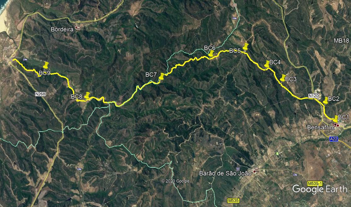
From the market cafe,(BC1) turn right and walk round the back of the market building. Walk down to the crossroads where you came in and turn left downhill. Fork left at the bottom, and follow the road as it slowly curves round to head north for 960m. At a fork (BC2) take the left hand and walk for 300m to join a main road. Bear right and walk for 250m before crossing the road and entering a lane on the opposite side. Walk along across a small bridge and at a fork take the left hand. Climbing steadily, stay left at a junction after 280m, and right at another one after a further 500m. Now climb a further 860m northwest to pass a ruin on a left hand bend.(BC3)
Continue in the same direction for another 960m, until the track turns southwest for around 150m. As it starts to curve round westwards again, stay right at a junction (BC4) and resume the northwesterly trend. Stay left after 450m, and come to a cross-tracks after another 830m (BC5). Go straight across and continue to climb to a high point after another 170m, heading rather more westerly now. Stay left at a fork after 130 m, turn more due west and descend steadily. After 780m come to a fork, with a small barragem down to the left, and take the left hand track. Bear right by a ruin after 210m, and walk across open land for 400m to a fork (BC6). Take the right hand and start to walk along an undulating track.
Stay left after 200m, left again after another 900m, and right 100m further on. Now start to head more southwest, (see a barragem in the valley on the left as you begin) and follow the track for almost 2k, finally descending steeply into a valley. Come to a junction, with a farm building in the trees to the left, and turn right.(BC7) Pass turns left and right after a short distance, and then walk down the valley, descending very gently the whole time, southwesterly for just over 2k. (This is the stretch where you will encounter all the water crossings after rain). After this the track turns to just north of west, and winds around for another 1.8k, as the valley widens out.
Come to a wide fork and turn left. Soon after turn right (BC8) and walk across the floor of the valley towards a small settlement on a hill. Past the first house (on the flat), swing round right and take the right at a fork, continuing to walk on level ground. Follow this track, with the hill to the left, for 1.94k, passing a large riding establishment on the left. Come to a point where a narrower track leads off acutely through the woods on the left, and follow it for 340m, to where a narrow valley opens on the left, with a house opposite. (BC9). Turn left uphill for 330m, then hairpin right and then left to climb further up onto a hilltop. There is only on track across this ground. Walk across the crown of the hill, down into a hollow and back up the other side. Pass a trig pillar on the left and start to descend. Go straight across at a cross-tracks and walk down into the outskirts of Carrapateira. Go round the curve of the first terrace of houses, then straight across into a narrow lane heading west downhill. Swing left as soon as you can and head southwest down the hill to the market square and the end of the stage.
GPS Points (37/8)
| 1 | Bensafrim | 09 | 20 | 62 | 44 | 14 | 81 | |||
| 2 | Turn left | 09 | 46 | 70 | 44 | 31 | 06 | 1.24k | ||
| 3 | Straight on | 10 | 19 | 74 | 45 | 45 | 82 | 2.30k | ||
| 4 | Bear right | 10 | 38 | 69 | 46 | 13 | 03 | 1.1k | ||
| 5 | Second left | 11 | 04 | 70 | 46 | 50 | 07 | 1.27k | ||
| 6 | Fork right | 10 | 56 | 37 | 47 | 50 | 44 | 1.75k | ||
| 7 | Turn right | 10 | 26 | 10 | 49 | 18 | 10 | 3.1k | ||
| 8 | Turn right | 10 | 02 | 19 | 51 | 30 | 30 | 4.27K | ||
| 9 | Turn left | 10 | 45 | 70 | 52 | 43 | 23 | 2.64k | ||
| Carrapateira | 2.21k |