Walk Twelve. Algarve Way Stage Nine a. Marmalete to Bensafrim. 29.2k
Ascent: 525m (descent of 877m)
Introduction
This is the first of two stages that make up the alternative approach to the finale from Carrapateira. Starting again from the hillside village of Marmalete, it cuts across country, almost always on a downhill trend, to the small market town of Bensafrim, which sits at the end of the A22 Motorway. All the paths are clear and wide, but as you see, the stage is long.
Directions.
Getting to Marmalete
From Monchique, drive down the road from the previous rendezvous point towards Portimao, and turn off at the first major road on the right, opposite a huge quarry, signed for Casais and Marmalete. Marmalete is 16k along this winding mountain road.
By Vehicle to Bensafrim
From Marmalete, drive along the main road west to Aljezur. Cross the river bridge and turn left. Follow this road all the way to Bensafrim, which is at the end of the A22 motorway. Take the first left off the roundabout to reach the town. Turn left at the open space off the main street with the market and café on the far side. The walkers will meet you at the café.
From the east, follow the A22 motorway to the end, and turn right into Bensafrim from the roundabout – then as above.
The Walk.
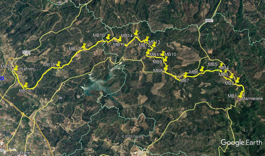
The route starts just like the Marmalete to Aljezur route. From the cafe at Marmalete (MB1) Walk the few metres to the bottom of the hill, turn right and follow the road around the western edge of the village. The road eventually leave the houses behind and curves upwards, joining a main road after around 1k. Turn left. Now the routes diverge. Walk down the main road for 950m, and find a broad track on the left, signed to Sapato. (MB2). Walk along here for 140m, and where twin tracks leave on the right, take the second one, heading southwest. Walk downhill, passing a set of ruins on the right, then rise slightly and come to a junction of several tracks after 650m (MB3). Bear right to walk a short distance up to another junction and turn left. Come to a high point after 170m, and bear left to walk downhill now to another complex junction after 110m.
Count from the left and take the fifth track, heading west of south, and follow as it winds through trees for 200m, to come to a cross-tracks. Go straight across, and soon at a fork go left, then soon again right at the next one.(MB4) The track starts to descend steadily from here, turning due south to a cross-tracks after 250m. Turn right and continue to descend. The track takes you rapidly downhill, round several very sharp bends, into the valley over the next 950m, to meet a hard surfaced road at the bottom (MB5). Now follow this road due south for 1.63k, past the tiny settlement of Zebro on the right. 700m beyond Zebro, pass a turning on the left heading steeply uphill, (MB6) and continue along the same road.
After another 1.56k, come down to a T junction and turn right, almost immediately walking past buildings on the left. 370m from the junction turn right with the track and walk southeastwards, with more houses and farms over on the right. Come to a tarmac road, with a large pond on the left and turn left. walk for almost 1k, passing more buildings, including a small cafe on the left. Arrive at a point with a large house on the right with a tarmac road running up beside it. Do not take the road, but the dirt track on the right, heading up to a ruined farm on the right. (MB8). Walk up the valley for 450m, and come to a division of tracks. Take the third from the right and head west of north, then sharply round to the left to face southwest.
Climb gently over 450m. Approaching the high point, dogleg sharply left and then right onto a broad piece of track, then at the high point take the right at a fork. (MB9). This track heads more or less due west for 440m. At a fork, with a wider track just visible ahead through trees, turn left and head south to join the wider track after 200m. (MB 10). Follow this rather undulating track west of south for 1.2k to come to a fork. (MB11). Take the right hand, still a wide track, and walk very slightly uphill for 850m, passing a farm on the right as you go. 190m after the farm, find a rough track leading off on the left at an acute angle. (MB12). The track swings round to the left and climbs in a winding fashion for 440m to reach a junction with a track on the right. Go straight on, continuing to climb, and reach a junction at a high point after another 460m. (MB13)
Take the second track from the right, and start to descend. Fork left after 210m, and swing round left to come to a junction after another 150m. Turn left, and after 150m turn right. Stay right at a fork after 140m, with a large pond and a farm on the right. Continue southwest for 470m, with more buildings over on the right, then drop down almost due south to a junction with a tarmac road. (MB14). Turn left. Still descending gently, follow the road for 870m to a point where a track crosses the road at an acute angle, and turn right. Fork left after a short distance, and then climb quite steadily over almost 1k, passing a farm on the right and later ponds on the left. Stay right at a junction with a track going down on the left, (MB15) and carry on to a high point after another 340m.
Swing round right at the top, then imediately turn left onto a track heading southwest and descending steeply. At the bottom after 340m, turn left and walk more southeasterly now, turning more southerly as you go over the next 630m, finally turn due south for a short time to reach a junction. Turn right and after 100m find a narrow footpath on the left, heading uphill.(MB16) Follow this for just over 100m to join a wide track again and turn left (this is a short cut). Turn right and at a cross tracks after 100m go straight across. Head more or less due south descending rapidly, for another 360m, and turn left at a junction. Continue to descend, a little more slowly over the next 1.5k until coming to a junction with a track coming in from the left, with buildings over on the right.(MB17).
Now follow the track down the wide valley. Stay left at a junction after 250m, and then head east of south and then due south for 2.57k to a junction on the left with a pond ahead and left. (MB18). Continue west of south for another 300m and take the left at a fork. Go round a shallow curve and then settle to a southwesterly trend for the next 2.2k, to pass a staggered cross-tracks. Then curve round to face due south and walk for another 1k to where the track swings round to the right, and another track comes in from the left. (MB19). As you walk along this track, south of west,it turns into a rough tarmac road, with houses on either side. Avoid all turns left and right, walk westerly and arrive at a fork after 1.67k. (MB20) cross the small bridge and bear left at the fork just beyond it. Take the third left and then second right to walk towards the centre of Bensafrim. At the crossroads at the end of Rua Direita after 190m, turn left and then first right to walk into the market square and the end of the stage. The market cafe will be closed, but there is another one out on the main road - over to the left and then right.
GPS Points (37/8)
| 1 | Marmalete | 18 | 33 | 12 | 39 | 58 | 99 | |||
| 2 | Bear left | 18 | 33 | 75 | 40 | 48 | 39 | 1.92k | ||
| 3 | First right | 18 | 21 | 11 | 41 | 05 | 36 | 790m | ||
| 4 | Stay right | 18 | 07 | 40 | 41 | 21 | 03 | 700m | ||
| 5 | Turn left | 18 | 01 | 36 | 41 | 43 | 94 | 1.15k | ||
| 6 | Bear right | 17 | 12 | 54 | 41 | 46 | 00 | 1.62k | ||
| 7 | Turn right | 16 | 28 | 21 | 41 | 38 | 09 | 1.57k | ||
| 8 | Turn firwst right | 15 | 42 | 74 | 42 | 14 | 09 | 1.84k | ||
| 9 | Stay right x2 | 15 | 46 | 21 | 42 | 42 | 25 | 860m | ||
| 10 | Stay right | 15 | 42 | 15 | 43 | 00 | 94 | 600m | ||
| 11 | Turn right | 15 | 05 | 72 | 43 | 16 | 56 | 1.22k | ||
| 12 | Turn left | 15 | 25 | 02 | 43 | 35 | 89 | 820m | ||
| 13 | Second left | 15 | 09 | 16 | 43 | 57 | 40 | 910m | ||
| 14 | Turn left | 14 | 45 | 84 | 44 | 24 | 80 | 1.23k | ||
| 15 | Fork right | 14 | 01 | 93 | 44 | 15 | 58 | 1.87k | ||
| 16 | Turn left | 13 | 32 | 73 | 44 | 30 | 49 | 1.46k | ||
| 17 | Bear right | 12 | 26 | 35 | 44 | 17 | 60 | 2.27k | ||
| 18 | Stay right | 11 | 11 | 89 | 43 | 36 | 77 | 2.85k | ||
| 19 | Stay right | 09 | 57 | 17 | 42 | 49 | 94 | 3.54k | ||
| 20 | fork left | 09 | 21 | 10 | 43 | 51 | 61 | 1.69k | ||
| Bensafrim | 09 | 20 | 62 | 44 | 14 | 81 | 620m |