Walk Eight. Algarve Way Stage 11. Carrapateira to Cabo de Sao Vicente. 25.8k Ascent: 690m
Introduction
At this point the alternative end stages of the Way come together again for the final leg to the Cape. The first half of this stage is a difficult route up and down hills and into coves down the west coast. The scenery is spectacular but you need to watch your feet!. The second half is a comparative stroll across open land, ending with a tortuous winding footpath in between limestone pavement to reach the final goal. The liaghthouse at the Cape is a fitting end to the crossing, with nothing beyond it but open ocean. NOTE: Before starting on this stage, you have to make sure that the tides are favourable. Two sections of beach are covered at high tide, so a start as the tide is receding is the ideal. Consult the Portuguese tide table in advance, and if you can, design your whole crossing with this in mind.
Directions
Getting to Carrapateira
From Bensafrim,and the A22 motorway, take the 120 north towards Aljezur. At the top of a long hill, with wind turbines on the left, turn left, signed to Alfambra and Monte Ruivo. At the T junction with the N268, turn left (signed to Lagos) and follow this road to Carrapateira. Park in or opposite the town square, where the walkers will join you.
From Aljezur, follow the 120 south to the junction with the 268, then turn right and follow as above.
By Vehicle to the Cabo de Sao Vicente
From Carrapateira, follow the 268 south to Vila do Bispo, where it joins the main coast road to Sagres. Follow the main road through the outskirts of Sagres, signed to the Cape. The lighthouse will be your guide as you near the Cape itself. Do not try to go any further. There is ample car-parking for you to await the arrival of weary walkers. If coming out from Lagos, simply follow the N125 to Sagres and then turn right todrive out to the Cape.
The Walk.
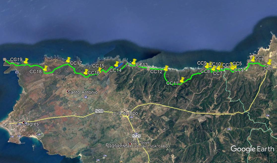
Leave Carrapateira (CC1) by crossing the main road at the zebra crossing and taking the tarmac road ahead, heading downhill. Pass the reed bed sewage farm on the right, and head south out of the valley. After 450m, pass a small house on the right and turn into a long straight downhill road. At the bottom, where the road turns right, find a footpath on the left (CC2) going through a narrow gap and then uphill, still going south. After 240m, emerge on a tarmac road and turn left. Round the bend and over the rise (large house on the corner), walk down towards a wide bay, with a large car park and lots of small buildings. This is Praia do Amado, a popular surfing beach. Drop down to the beach and walk more or less the whole length. Pass two coves, and coming to the third one, which is the end of the beach, turn left away from the sea .
Walk due south for just over 200m, to find a sandy track heading up to the cliff on the right. (CC3) After 150m, after climbing a steep sandy gulley, reach a dirt track and turn right. Walk round a bend for 120m, and come to a point where a track comes in from the right, and a narrow footpth heads off right, due west. Follow this as it descends into a gulley and then climbs out again, running round a hill with the sea on the right. After 190m, the path turns uphill and climbs steeply to reach a wide track near a house. (CC5). Turn right here and walk down a long hill towards the next cove, the Praia de Muracao. When close to the sea, turn left and walk inland.
There are two ways down onto the beach. After a very short distance, find a rocky descent on the right, which requires some agility. Failing that walk inland a little further to find an easier way down. Now walk across the beach to the far end, avoiding the obvious road coming down halfway along. Find a narow gulley floored with black rock, (CC6) and walk up it. This can be wet and slippery, take care. About 100m in, look for a way out of the gulley on the right, climb to a narrow path and walk up the side of the narrow valley. Curve round to the right and climb up to a grassy saddle. Head south for around 100m, at which point the path turns right. (CC7) and heads southwest towards the sea. Coming close to the cliff edge, follow it round for 140m, then join a wider dirt track heading just east of south.
After 200m, find quite a wide track heading off on the right, (CC8) and follow it down to a small rough patch of open ground. Ignore the continuation of the track, and take the narrow footpath ahead instead. This runs out towards the sea for 150m before turning left and heading steeply downhill towards a cove of sand and rocks below. This is quite tricky, take it steadily. Reaching the cove (CC9), walk across behind the large rock sitting at the entrance near the sea. At the base of the cliff opposite, find a rocky path heading up roughly southeast, and climb up to reach a narrow ridge, with the cove on one side and the sea on the other. Walk along the ridge and climb the narrow rocky path beyond it, to reach level ground after 250m. (CC10).
See the start of a wide dirt track ahead and follow it for the next 2.4k, over a wide stretch of moorland. Arrive at a point where two tracks lead off to the right. (CC11). Take the second one, heading southwest. After just over 200m, go straight across at a cross tracks, and after another 150m, staty left at a junction. Now begin a long, winding 1.8k descent back towards the sea. Arrive at a junction at the back end of a cove (CC12) and turn right to reach the beach at Praia de Barriga. Turn left along the beach and walk for just under 2.5k, passing another cove on the way, then between the cliff and a large pyramid shaped rock, to reach the beach cafe at Praia de Castelejo.(CC13),
A refreshment stop is a good idea here, after which continue along the beach to the last possible turn on the left before the massive cliff ahead. Find a narrow footpath climbing steeply up between two valleys, and onto a ridge. The gradient eases eventually, and after 1.12k, come to a cross-tracks on level ground. (go past a turn to the right just a little earlier). (CC14). Turning right here will take you out to a headland with an old customs house on the edge of the cliff, with extraordinary views, but then you have to comer back to the cross-tracks. From the main route, turn left at the cross-tracks and then very shortly right. 330m up a stoney lane, turn left and walk along to the spectacular Torre de Aspa, part of the Portuguese mapping triangulation system. (Most of the trig points are much smaller!).
Rest here or pass by on the left, and after 400m turn right at a junction. Just over 300m further on turn left at another junction. After 540m, bear right at a fork. (CC15). 1.1k further on, just west of south, come to another fork and take the right again. (CC16). More southwest now, walk another 800m and bear right at a junction. Very soon take the left at a fork and soon again take the right at a second one. Walk towards the sea for 140m and turn left. 700m further on, after a left hand curve, stay left. (CC17). Walk due south for just over 1.3k to a cross.tracks with a small settlement over to the left.
Go straight across and walk just west of south for 660m to another junction (CC18) and turn right, towards the sea. What steadily becomes a narrow footpath heads out seawards and runs quite close to the cliff for a while before turning away again. Stay right at a junction after just over 1.4k, and after another 450m, head southwest across a jumble of tracks heading for the cliff. (CC19). the path (just follow the sandy indentation between the limestone rubble) heads out to the cliff again, and runs along close to the edge around a curving line. Past the end of this curve come to another wide path heading to the edge of the cliff, and continue southwest. After 300m, the track curves round to the left and comes up to a tarmac road. Turn right and walk along to the lighthouse. This is the end of the Algarve Way. Next stop America.
GPS Points (37/8)
| 1 | Carrapateira | 11 | 01 | 42 | 53 | 44 | 73 | |||
| 2 | Fork left | 10 | 27 | 32 | 54 | 13 | 81 | 880m | ||
| 3 | Turn left off beach | 09 | 40 | 10 | 54 | 16 | 57 | 1.7k | ||
| 4 | Turn right | 09 | 33 | 44 | 54 | 18 | 40 | 260m | ||
| 5 | Turn right | 09 | 31 | 04 | 54 | 26 | 18 | 260m | ||
| 6 | Turn left | 09 | 10 | 64 | 54 | 37 | 14 | 780m | ||
| 7 | Turn right | 09 | 01 | 83 | 54 | 36 | 02 | 310m | ||
| 8 | Turn right | 08 | 49 | 30 | 54 | 40 | 37 | 590m | ||
| 9 | Turn right | 08 | 46 | 41 | 54 | 54 | 49 | 530m | ||
| 10 | Straight up | 08 | 37 | 78 | 54 | 55 | 62 | 400m | ||
| 11 | Turn right | 07 | 26 | 98 | 54 | 47 | 99 | 2.34k | ||
| 12 | Turn right | 07 | 04 | 56 | 55 | 41 | 36 | 2.25k | ||
| 13 | Castelejo (cafe) | 05 | 59 | 53 | 56 | 41 | 22 | 2.80k | ||
| 14 | Turn left | o5 | 18 | 90 | 56 | 56 | 51 | 1.58k | ||
| 15 | Turn right | 04 | 35 | 23 | 57 | 02 | 32 | 1.85k | ||
| 16 | Fork right | 04 | 03 | 09 | 57 | 14 | 03 | 1.1k | ||
| 17 | Fork left | 03 | 36 | 52 | 58 | 11 | 08 | 1.85k | ||
| 18 | Turn right | 02 | 36 | 93 | 58 | 17 | 22 | 1.92k | ||
| 19 | Stay right | 02 | 01 | 90 | 59 | 03 | 82 | 1.09k | ||
| Lighthouse | 01 | 25 | 35 | 59 | 44 | 04 | 1.69k |