Walk 18. Algarve Way Stage Ten. Aljezur to Carrapateira 18.6k Ascent: 466m
Introduction.
Having arrived in Aljezur, you can´t go much further west without falling into the sea, so you have to turn south. This involves an intial short climb to Aljezur castle, followed by a long trek in woodland parallel to the coast, but sadly never seeing the ocean. Eventually, the sea does make an appearamce, as you pass through a scattered community at Monte Novo, The end of the stage is a delightful descent with the sea always visible, and a final section which takes you out to the very edge of the water. There is a tarmac alternative at the end which is 2.3k shorter, but it is long, straight and boring.
Directions.
Getting to Aljezur.
From Marmalete, simply follow the main road west and Aljezur will get in the way before you fall into the sea, about a 15 minute drive. Park on the left before the river bridge. The walkers will come down this road. Coming from the south, drive to the western end of the A22 motorway at Bensafrim, and take the first turn left at the roundabout. This will take you straight to Aljezur. Turn right over the river and park.
By Vehicle to Carrapateira
Turn left after the Aljezur bridge, and follow the main road south. Turn off right on the N268 for Carrapateira, which you should reach in about 20 minutes. Park on the edge of the town square,
The Walk.
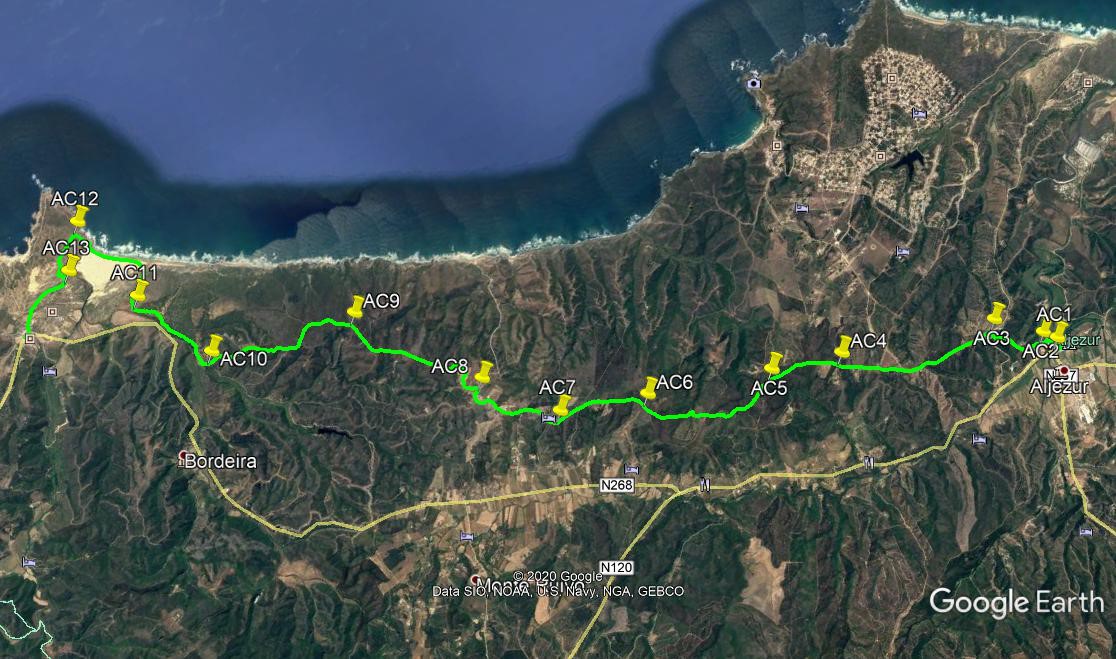
With the bridge at Aljezur behind you, (AC1)turn right and walk north for 300m. Past the Museu Municipal, turn left and bear round to the left to climb the hill. Reaching the entrance to the castle, bear right and drop down. Facing buildings (AC2) bear right again and walk along the side of a hill to reach a road. Turn right and walk for just over 600m to a junction. Turn right once more and walk up a short distance to another junction and turn left.(AC3) Walk along the road for 1.57k to a fork with a minor tarmac road on the left, and choose this direction. Continue southwest for 860m, taking the right hand at a fork, and reaching a crossroads shortly after. (AC4).
Go straight across here as the road surface slowly deteriorates, and follow it as it soon turns due south, and comes to a cross-tracks after another 1.22k. (AC5). Go across on the diagonal and continue on this track, avoiding all turns left and right, for 2.44k, to another cross-tracks. (AC6). Go straight across again, and do the same after another 1.1 k. Take the left at a fork after 450m, (AC7)and then swing right past a building on the right. Continue to walk southwesterly for another 1.33k, passing two tracks coming in from the left, and walk past the first houses of the scattered settlement of Monte Novo. At a junction swing round to the right, pass another junction on the left and at the next junction, signed to Malhada da Cerva, bear left. (AC8).
Follow the road through the rest of the houses and out into open country beyond. Avoid taking any tracks left or right and after 2.55k take the left hand at a fork, as the sea becomes visible over to the right.(AC9). Now head more or less south on this same track, avoiding turns to the right towards the sea. Finally come to a steep descent through a cutting, taking you down to open ground with a farm close by on the right, after 2.8k. (AC10). Walk round the farm to the right and cross a flat open field ahead. Here is a choice. Turning left and almost immediately right will taake you to a main road and a long, very boring but easy walk into Carrapateira. Going staright ahead will take you to the sea and an interesting end to the day.
To do this, after going ahead, soon turn left on a sandy track that runs parallel to the main road for around 1.4k. Arriving in front of some ruins, (AC11) turn right with the track and soon turn right again to walk northwest behind sand dunes. After 700m, cross the dunes and walk out towards the sea. Walk across the bay at the edge of the sea to the far side, and make your way up the low cliffs. Soon come to a vehicle turning point and walk forward to a junction. (AC12). Turn left and walk for almost 1k. Pass a car park, and just before the first houses, turn right on a sandy track heading through sand dunes. (AC13). After 750m, turn left into another tarmac road, and walk up to the main road. Turn right to walk the short distance into Carrapateira, and cross the road to enter the market square. This is the end of the stage.
GPS Points (37/8)
| 1 | Aljezur | 18 | 59 | 83 | 48 | 12 | 89 | |||
| 2 | Bear right | 18 | 54 | 32 | 48 | 20 | 70 | 870m | ||
| 3 | Turn left | 18 | 33 | 92 | 48 | 44 | 28 | 990m | ||
| 4 | Straight on | 17 | 14 | 10 | 49 | 12 | 66 | 2.7k | ||
| 5 | Left and right | 16 | 37 | 39 | 49 | 24 | 88 | 1.24k | ||
| 6 | Cross tracks | 15 | 33 | 49 | 49 | 48 | 93 | 2.45k | ||
| 7 | Fork right | 14 | 48 | 69 | 50 | 06 | 29 | 1.58k | ||
| 8 | Fork left | 14 | 20 | 45 | 50 | 49 | 74 | 1.7k | ||
| 9 | Stay left | 13 | 37 | 70 | 52 | 09 | 02 | 2.73k | ||
| 10 | Stay right | 12 | 20 | 04 | 52 | 30 | 12 | 2.8k | ||
| 11 | Right by ruins | 11 | 58 | 59 | 53 | 26 | 43 | 1.73k | ||
| 12 | Turn left | 11 | 48 | 83 | 54 | 29 | 05 | 2.1k | ||
| 13 | Turn right | 11 | 32 | 23 | 54 | 02 | 99 | 980m | ||
| Carrapateira | 11 | 01 | 42 | 53 | 44 | 73 | 120m |