Walk Twelve. Algarve Way Stage Nine.Marmalete to Aljezur. 18.5k Ascent: 379m
(There is a total of 755m of descent). With extension to Monte Clerigo Beach.
Introduction
At Marmalete, the Algarve Way route divides. One leg heads straight for the coast near Aljezur, and then down close to the Atlantic from there to Cape St Vincent. The other takes a more cross country line down to Bensafrim and from there across to the coast at Carrapateira before turning south to the Cape. The Aljezur route drops down to the valley of the Passos river, and follows it all the way. The walking is easy, and the navigation straightforward.
I have added an alternative start and finish to this walk, for those not doing the whole Algarve Way. It takes you to the coast beyond Aljezur, to a delightful village called Monte Clerigo. The whole walk from Marmalete would be over 26k, so I have offered a start-point some way down the main road. For details, see after the main route photo below.
Directions
Getting to Marmalete.
From Monchique, drive down the road from the previous rendezvous point towards Portimao, and turn off at the first major road on the right, opposite a huge quarry, signed for Casais and Marmalete. Marmalete is 16k along this winding mountain road.
By Vehicle to Aljezur.
From Marmalete, simply follow the main road west and Aljezur will get in the way before you fall into the sea, about a 15 minute drive. Park on the left before the river bridge. The walkers will come down this road. Coming from the south, drive to the western end of the A22 motorway at Bensafrim, and take the first turn left at the roundabout. This will take you straight to Aljezur. Turn right over the river and park.
The Walk.
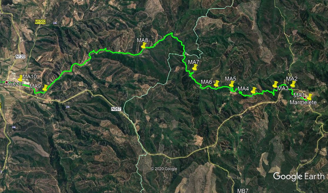
From the cafe at Marmalete (MA1) Walk the few metres to the bottom of the road, turn right and follow the road around the western edge of the village. The road eventually leave the houses behind and curves upwards, joining a main road after around 1k. (MA2). Turn left and after 100m, cross the road and take the minor tarmac road heading steeply downhill. After 200m, turn left on a track and immediately fork right. Fork left after 120m, and left again after the same distance. Pass to the left of some old buildings, and 250m on hairpin left to walk due south.(MA3). 220m on hairpin right and head back northwesterly.After another 200m stay left at a fork, and walk on to a junction just over 300m further on. Turn left, bear right and after 100m turn right. Stay left at a fork down to a house after 230m, and walk on to a fork after 240m more. (MA4)
The descent has been fairly gentle until now, but it becomes a little steeper from here. Take the right and 520m down go right at a sharp bend, and after another 730m, do the same again to continue to descend. (MA5). Almost 1k further on, as the land levels out somewhat, pass a track coming in from the right (MA6), and go straight on. Follow the main track along the eastern side of the valley, making sure to stay on the right of the valley floor/stream. After 1.57k, at the top of a loop in the track, see twin tracks heading uphill on the right (MA7) and continue. Now drop down to the valley floor and cross to the western side. The track now heads due north for a while, passing an isolated farm about 550m from the crossing, and then it turns more northwest with the valley after another 400m.
After 800m, take another sharp turn to the left (more buildings across the valley on the right) with the track and head southwest. Cross the valley again, join another track coming from the right, soon pass a farm on the right and after 600m, more buildings on the left. After another 640m, come to a point with tracks leaving left and right, with more houses down to the left. (MA8). Go straight on again. The track improves in quality steadily as you progress down the valley. 800m further on go through a cross-tracks, with a large new house on the hill ahead and right. Heading more or less due west on this section, pass a house on the left after just over another 1k. Soon after this the track turns southwest again, and after 720 from the turn, pass through the settlement of Cerca dos Pomares.
Following this, walk round a wide left hand curve with the stream, and resume the southwest trend. After another 2.33k from Cerca, come to a point with a house standing just before a left hand bend, and a rough track going uphill on the right. There are other buildings and another track in the valley on the left. (MA9) Walk up to level ground and join a wide track after 220m. Continue to a cross tracks and go straight across. Now follow the road a it descends towards Igreja Nova, a satellite town of Aljezur. Stay for refreshment here, (MA10)or head straight on west, down the hill and out of Igreja Nova, to follow the main road across the valley and over the bridge into Aljezur itself. This is the end of the stage.
GPS Points. (37/8)
| 1 |
Marmalete |
18 |
33 |
58 |
|
39 |
58 |
70 |
|
|
| 2 |
Turn left |
18 |
49 |
96 |
|
40 |
23 |
80 |
|
1k |
| 3 |
Sharp 2nd left |
18 |
52 |
05 |
|
40 |
41 |
42 |
|
920m |
| 4 |
Bear right |
18 |
41 |
93 |
|
41 |
24 |
\95 |
|
1.33k |
| 5 |
Hairpin right |
18 |
50 |
41 |
|
41 |
57 |
64 |
|
1.28k |
| 6 |
Stay right |
18 |
50 |
93 |
|
42 |
21 |
55 |
|
900m |
| 7 |
Hairpin left |
19 |
11 |
68 |
|
42 |
56 |
38 |
|
1.58K |
| 8 |
Fork right |
19 |
40 |
04 |
|
44 |
18 |
15 |
|
3.83K |
| 9 |
Turn right |
18 |
45 |
49 |
|
46 |
57 |
14 |
|
5.30K |
| 10 |
Straight on |
18 |
57 |
87 |
|
47 |
36 |
72 |
|
1.19k |
| \ |
Aljezur |
18 |
59 |
83 |
|
48 |
12 |
89 |
|
900m |
Monte Clerigo Extension.
Start. You can start from Marmalate, and walk the whole of the Algarve Way Stage to Aljezur before adding on the 8k or so to Monte Clerigo. If you want to shorten to around 22k, drive down the Aljezur road from Marmalete for 1.8k, to find a turn to the right, signed to Rocha and acouple of other places.(1) Leave the car here. Take the track to Rocha, and walk down for 770m to a junction. (2)This is the main Algarve Way track, so turn left and walk for 540m, arriving at AW point 4. Now follow the Algarve Way route all the way to Aljezur.
Arriving in Aljezur, turn left having crossed the bridge, (3) and walk along the main road for 280m. With a bank (BPI) on the left, and a gift shop above right, take a ramp on the right, (4) a sharp turn from the road, and follow a winding lane up to a narrow road running along the hillside,after something like 100m (5). Turn left and follow the road as it leaves the houses behind, turns right and climbs up and away from the town. After 740m, come to a junction and bear right, bearing right again after a short distance (6). Now simply follow this road all the way to the coast, turning left at the end to walk to the houses and cafes at Monte Clerigo.
