Walk Seven. Algarve Way Stage Eight. Monchique to Marmalete. 14.4k
Ascent: 634m
Introduction
This is the shortest stage on the Way, and strong walkers might want to combine it with the next one, down to Aljezur, another 18.6k, as this stage is almost all downhill. However, the climb to Foia from Monchique is quite demanding (though nowhere near as hard as Picota), and there could be an argument for a shorter day if you have walked from Silves the day before, or even simply climbed Picota. The route leaves Monchique, and climbs quite quickly to the summit of the highest point of the Serra de Monchique at Foia. Foia is a disappointment after Picota, covered as it is with communications masts and concrete buildings, including tourist shops and a (quite welcome) cafe. This is followed by a long undulating descent to the village of Marmalete, on the far western edge of the Serra. The views on this day are among the best of the whole route, so enjoy! After climbing out of Monchique, the general direction today is south of west.
Directions.
Getting to Monchique.
From the Odelouca crossing point, continue up the road to Alferce. Turn left towards Monchique. Reaching the traffic lights, turn left and left again into the forecourt of the garage and café.
From the south, take the 266 from Porto de Lagos (follow signs to Monchique from Silves, Portimao or the motorway), to drive the 16k to the traffic lights. Turn right into the forecourt of the filling station.
By vehicle to Marmalete.
From Monchique, take the 266 back towards the coast. Opposite the huge quarry on the left, turn right, signed Casais and Marmalete. This road will take you straight to Marmalete, about 16k further on. Drive about 200m into the village, and turn left down into a small square with a café on the right. The walkers will meet you there.
The Walk.
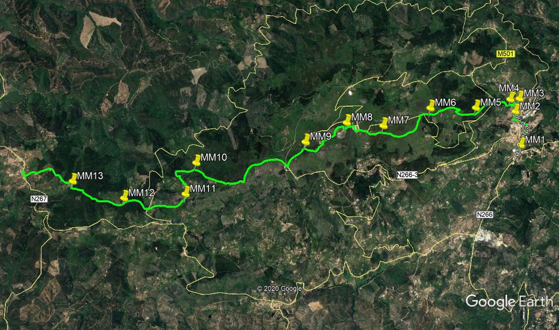
From the roundabout on the outskirts of Monchique, (MM1) turn right and follow the main road into the town centre. In the main square, make for the far right hand corner, with a couple of large garage doors facing you, and a cafe on the right. Turn right up the hill here (MM2). Walk in a straight line just east of north for 300m, first uphill and then gently down,. Turn left at the Rua do Prior Francisco etc, (MM3) and wind uphill, first left and then right.(Rua da Fonte Velha). 100m after the right hand bend turn a hairpin left into Rua do Santo Andre. After just over 100m, turn right up the Caminho do Convento, and climb to level ground. Ahead you can just see the old convent that overlooks the town, but you want a rough footpath turing off uphill to the right, a few metres after reaching the level. (MM4) .
Follow this up through trees. At one point it becomes a roughly paved and edged footway. Having started off northwest, the path turns west and finally southwest as it comes up to join a wide tarmac road. Cross over and walk up for less than 100m to find a track on the right. This is a sharp turn, starting off due north, but quickly turning southwest and running parallel with the main road for just over 500m. At a fork here take the right hand (MM5), and walk due west for a short time. Avoid turns to right and left around the 200m mark, and continue as the track winds uphill, with trees to the right and opening views left, with farm buildings at intervals. Emerge into open country, and around 1.14k from MM5, come to a fork where one track heads west of south, and the other goes due west uphill, with trees on the left.(MM6)
Take the westerly one and climb a short distance to meet a narrow tarmac road at the top. Walk straight ahead for 100m and find a cart track heading due south (left) across the moor. Follow it for around 1k as it curves widely and gently round to the right, becoming a simple footpath and steeper towards the end. Meet a track coming in from the left (MM7), and continue ahead, rising to meet the first of the concrete buildings of Foia on the left. Now follow the road towards the main group of buildings ahead. Turn left in front of the buildings (the cafe is round the corner), and left again at the end of the car park. Bear left at the next junction and head up towards a fence with more buildings and masts beyond it. This is a secure military zone.
At the gate/fence (MM8), turn right and work your way round the perimeter on a footpath. At the far side, head southwest towards another installation, working round this to walk down to a third one. Find a wide gravel track coming out of this and follow it down to a main road. (MM9). (you can walk down the road all the way from the top if you wish.) Walk down the road for almost 500m to a junction with a wide gravel road on the right. Follow this as it curves round to the left and down towards a line of six wind turbines. Go past all of them (the first is away to the left), and after the last one simply follow the now narrower track downhill (MM10).
300m down come to a junction on the left and follow this track on more or less level ground. After almost 300m, turn down to the right to avoid a small group of houses, and descend. Soon after the houses, the track turns due south and continues down past another farm on the left to a junction. (MM11)Turn right and walk westards for something over 700m. Spot a main road through the trees and fork right to meet it. Go straight across and follow the track round a very wide left hand bend for 600m. At a fork (MM12) take the right hand, avoid an immediate turn to the right, and fork left after a short distance. Pass two or three turns to right and left, maintaining a roughly northwesterly line, and fork left after 750m. Now heading almost due west, come to a T junction and turn right. The track soon turns northwesterly again. After 600m, it rounds a bend to the left, with a large building on the left, and heads down to the village of Marmalete, passing through a small industrial site to reach the main road after another 600m. Turn right to walk to the village centre, and turn left down the hill to the cafe on the right where the stage ends.
GPS Points- (37/8)
| 1 | Sharp right | 18 | 43 | 88 | 33 | 20 | 05 | |||
| 2 | Turn right | 19 | 05 | 21 | 33 | 23 | 99 | 850m | ||
| 3 | Turn left | 19 | 13 | 42 | 33 | 20 | 90 | 270m | ||
| 4 | Turn right | 19 | 12 | 67 | 33 | 29 | 10 | 350m | ||
| 5 | Fork right | 19 | 06 | 63 | 33 | 59 | 06 | 920m | ||
| 6 | Turn right | 19 | 05 | 77 | 34 | 36 | 77 | 1.15k | ||
| 7 | Stay right | 18 | 54 | 69 | 35 | 14 | 01 | 1.17k | ||
| 8 | Turn right | 18 | 56 | 76 | 35 | 41 | 78 | 810m | ||
| 9 | Turn left | 18 | 45 | 32 | 36 | 13 | 27 | 1.1k | ||
| 10 | Turbine 6 | 18 | 33 | 42 | 37 | 38 | 60 | 2.67k | ||
| 11 | Turn right | 18 | 14 | 08 | 37 | 47 | 45 | 1.1k | ||
| 12 | Fork right | 18 | 11 | 61 | 38 | 36 | 71 | 1.37k | ||
| 13 | Turn right | 18 | 22 | 53 | 39 | 17 | 15 | 1.1k | ||
| Marmalete | 18 | 33 | 73 | 39 | 58 | 14 | 1.43k |