Walk Fourteen. Algarve Way Stage Seven. Silves to Monchique. 30.2k
Ascent: 1520m
Introduction.
The stats above should tell you that this is by far the toughest stage on the Algarve Way. Strong walkers will be able to tackle it, but there is an argument for splitting the stage at the crossing of the Odelouca river, leaving the ascent and descent of Picota as a separate outing. This will necessitate having a support vehicle to take you back to Silves at the end of the first half. That first half is a relatively gentle traverse of two ridges heading north from Silves to the foot of the Serra de Monchique. From there the trail lies up a charming hidden valley and then up a combination of tracks and tarmac to the summit of Picota, second highest peak of the Serra, before a final descent to the town of Monchique. Note that after heavy rain, there could be problems on the second half - see the walk description - but there is an alternative route. You might not quite think it at the time, but the views from the high point are worth the climb! The trend on this section, running counter to the general direction, is north.
Directions.
Getting to Silves
From the East
Drive along the 124 main road from Messines. At the double roundabout on the outskirts of Silves, take the second on the right which goes to the left of the town cemetery. Take the first right after the cemetery. Rendezvous where the Silves irrigation canal goes under the road to Sao Marcos da Serra, about 300m along.
From the West and South:
Leave the A22 motorway at the Silves/Lagoa junction, and drive towards Silves. Turn left to cross the river facing the castle, and right at the lights. At a double roundabout, go round the first, across a short link and take the road ahead going to the left of the cemetery. Turn right past the cemetery. Rendezvous as above.
By vehicle to the Odelouca Crossing..
Take the 124 road out of Silves towards Portimao and Monchique. After about 10k, cross a river and take the next right immediately afterwards, by a small bar. (If you pass the Ourique Restaurant on a bend on the left, you have gone too far.) Follow this road north for another c10k to the hamlet of Cortes. Shortly after this, on a hill, take a wide gravel road on the right, heading slightly downhill. Look for a small shed over the bank on the right. This is where the walkers will emerge.
The Walk. (GPS point designations have been split into two - SO (Silves - Odelouca) and OM (Odelouca - Monchique).
Part One
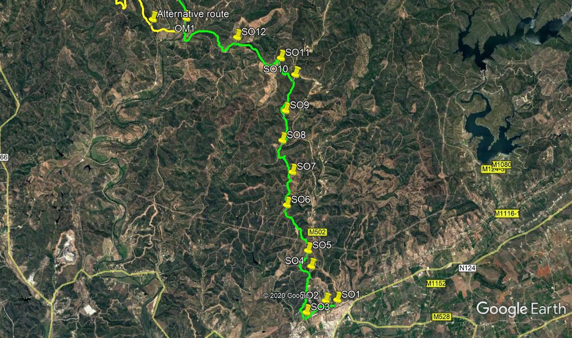
Start from the finish point of Stage 6, at the canal outside Silves. This is a levada, an irrigation canal used by the agricultural communities along the Arade valley, mainly citrus growers. It is fed from the Barragem do Arade, which you passed on the previous stage.
If coming out of Silves, turn left onto the left side of the levada (SO1) and walk along for 330m, until confronted by an acqueduct. Drop down to the left immediately before it, onto the road below. Go under the acqueduct and fork left uphill (SO2). Curve round to the left and walk along into the village of Monte Branco. After 750m, at the end of a long row of two storey houses with balconies facing the road, turn right downhill into a shallow valley (SO3). Fork right in front of the first building on the hill as you begin to climb, and then take the first left to climb steeply to a track at the top. Turn right here.
See a small group of houses below on the right as you walk the next 500m, passing a farm on a rise at the end. Over the rise walk alongside a road for a short distance before going straight across due north at a cross tracks. Pass a turn to the left after 370m, and take the next left after another 170m. (SO4) Pass two tracks on the right, and stay right past a complex set of paths on the left. Now take the right hand at a fork and descend gently, passing a track coming in uphill from the right. Now curve round right and start to climb, heading for and reaching a ruin. (SO5). From here head northeast, turning left at a junction after 240m. Now begins a long climb, interrupted by short dips, of just over 1.5k, heading in a straight line west of north. At this point the track levels out and turns due north along a ridge (S06).
The route winds a bit and undulates, but the direction is steady. Coming to the end of 1.14k, descend into a hollow, and take the left hand (more or less level) at a fork. (S07). After another 420m due north, come to a 3-way junction and take the narrow track straight across downhill. At the bottom, turn right and walk round the end of a large pond, turning a hairpin left at the end to walk along the far side. Emerging onto the valley floor, turn right and walk for 330m, taking the second stream crossing on the left. (SO8). Over the stream , or dry bed, fork right and follow this track fairly gently uphill for 1k to reach more or less level ground once more. (SO9). At the junction turn right and continue east of north for 1.23k, turning here more to west of north (SO10).
Stay left at a fork on the curve. Stay on the ridge over the next 800m, as the land rises and falls gently. Come to a junction with a cultivated area ahead, (SO11) and turn right. At a junction in the corner of the field, turn left, and after 430m, fork right. Now begins a long downward trend. After 1.2k, come to a junction with several tracks coming down to the valley (SO12). Bear left here and continue to descend by stages. Follow the track round a fairly sharp bend to the right after a group of houses, and then continue round a very wide sweeping curve to the left. When the track takes on a clear southwesterly direction, look for a track on the right, opposite a point where several tracks come down the hill from the left. There are buidlings ahead and right. Turn down this track, which soon turns into a tarmac road. After crossing the Odelouca River on a bridge, this leads on to a main tarmac road. This is the end of the first half of the stage. You can arrange your pickup from here if you wish. NOTE: The alternative route to avoid possible water problems starts just after the river crossing.
Getting to the Odelouca crossing.
Take the 124 road out of Silves towards Portimao and Monchique. After about 10k, cross a river and take the next right immediately afterwards, by a small bar. (If you pass the Ourique Restaurant on a bend on the left, you have gone too far.) Follow this road north for another c10k to the hamlet of Cortes. Shortly after this, on a hill, take a wide gravel road on the right, heading slightly downhill. Look for a small shed over the bank on the right.
By Vehicle to Monchique.
Take the N124 from Silves towards Portimao. At a roundabout turn right for Monchique. Alternatively, use the A22 motorway and turn off at the Portimao exit. Turrn right for Monchique and follow signs. The rendevous is on the outskirts of the town, just past a large filling station.
Part Two
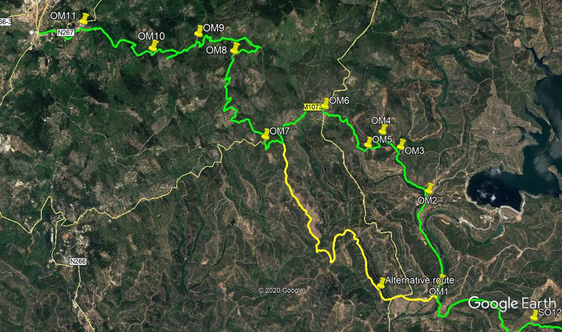
At the road junction (OM1), turn right and walk north for 1.7k. Come to a track on the left, signed to Fonte Santa (OM2), and walk down to a shallow valley with tree cover. Over the next 1k, there are three stream crossings to negotiate. Take these as you will. There are sometimes makeshift bridges, but the best and safest way is to wade or paddle across. After a lot of heavy rain, this route can be impassable. A workable alternative is shown on the photo, but not described. After the third crossing. come to a small clearing. (OM3). An obvious dirt track goes off up on the left, but just to the right of it is a narrow footpath. (If you can´t find the entrance from the clearing, go up the dirt track for a few metres and turn right to locate the path.) Follow this path west of north as it rises first over rocky ground, then drops into a green valley and finally climbs through trees, over the next 430m. Come to a point where you can see a ruined building ahead. This is Fonte Santa. (OM4).
Just before the well building, find a gap in the vegetation on the left, and drop down into the stream bed, clambering out on the far side and bearing right uphill. Follow the narrow footpath steeply uphill, as it passes immediately left of a shale rock face. After around 120m the footpath gives way to a wider dirt track, heading roughly southeast. Follow for 100m, then turn right uphill. After another 100m, turn left and almost immediately right again to continue the upward trend. After 170m, join a track coming in from the right, and very soon reach a junction. (OM5) Turn right here. After almost 200m, the track dog-legs to right and then left, heading west of north for a further 300m to reach a complex junction of tracks. Take the second left, heading more northwest. After another 160m of climb, the way finally levels out. At a junction turn left. This track now winds through scrub and trees for 470m, ending at a tarmac road. (OM6).
Turn right and take the first left, another but narrower tarmac road, heading generally west and then southwest, to reach the hamlet of Fornalha after 700m. Walk through the settlement, staying right at a junction on the left at the end of the houses. Drop down into a dip in the road, then start to climb again as the road winds around for 1k. Coming to the top of a rise following a sharp right hand bend, find a tarmac road on the right, heading up northeasterly. (OM7). Climb for 850m and come to a narrow tarmac road going off on the left, with houses along it. Swing round right past this and continue to climb. the road snakes up for another 1.5k, passing a large farm near the top, after which a long straight ascent takes you to a junction with another road. (OM8)
. Walk along to the right for just over 500m, still rising, but very gently now, to reach a hairpin bend into a gravel track on the left. (A forest track goes off to the right just afterwards). Follow the track past a farm building on the left, and then stay left at a fork. Swing round to the left and pass ruins right and another farm left, staying left once more at a fork. After another 300m, with buildings down to the left, the track turns sharply niorth for a short time, then describes a `V`shape southwest and northwest before heading southwest again for 200m. Now it curves sharply right again before finally heading northwest to a junction. (OM9) Turn left here, passing a small form building on the left. Just after the farm track swings sharp right, take a less obvious cart track on the left and follow this to a tarmac road. To reach the summit of Picota, turn left, walk up to the end of the tarmac and clamber up the rocky path to the fire tower. Go on, you can´t miss it now,
you´ve come so far!
To continue to Monchique, cross the road and take the track opposite. Pass two tracks on the right, and after 320m, turn left at a junction. After another 160m, swing sharp right (OM10). Stay left at a junction after 560m, and simply continue downhill for just over 1k . the surface turns to tarmac on the way, and ends at a junction with another road. (OM11). Turn left to walk to the outskirts of Monchique, another 800m. The stage ends at a roundabout, with a large filling station off to the left, and a supermarket straight ahead. Monchique centre is up to the right.
GPS Points (37/8)
| 1 | Levada | 11 | 56 | 22 | 25 | 59 | 66 | |||
| 2 | Turn right | 11 | 55 | 55 | 26 | 13 | 66 | 380m | ||
| 3 | Turn right | 11 | 44 | 20 | 26 | 36 | 97 | 740m | ||
| 4 | Bear left | 12 | 29 | 67 | 26 | 31 | 13 | 1.55k | ||
| 5 | Ruin | 12 | 44 | 65 | 26 | 34 | 81 | 750m | ||
| 6 | Turn right | 13 | 28 | 83 | 27 | 00 | 02 | 1.8k | ||
| 7 | Fork left | 14 | 00 | 50 | 26 | 52 | 87 | 1.17k | ||
| 8 | Cross stream | 14 | 30 | 95 | 27 | 04 | 71 | 1.3k | ||
| 9 | Turn right | 14 | 59 | 36 | 27 | 00 | 50 | 1k | ||
| 10 | Fork left | 15 | 33 | 73 | 26 | 48 | 60 | 1.23k | ||
| 11 | Turn right | 15 | 49 | 41 | 27 | 05 | 68 | 780m | ||
| 12 | Stay left | 16 | 10 | 75 | 27 | 58 | 54 | 1.85k | ||
| Odelouca X | 16 | 22 | 14 | 28 | 59 | 92 | 2.33k | |||
| 1 | Turn right | 16 | 29 | 90 | 29 | 00 | 37 | |||
| 2 | Fork left | 17 | 18 | 46 | 29 | 07 | 70 | 1.68k | ||
| 3 | Fork left | 17 | 42 | 04 | 29 | 26 | 25 | 1k | ||
| 4 | Cross ditch | 17 | 50 | 01 | 29 | 38 | 77 | 430m | ||
| 5 | Turn right | 17 | 42 | 94 | 29 | 49 | 18 | 520m | ||
| 6 | Turn right | 18 | 03 | 07 | 30 | 17 | 78 | 1.17k | ||
| 7 | Turn right | 17 | 47 | 33 | 30 | 56 | 42 | 2k | ||
| 8 | Turn right | 18 | 29 | 81 | 31 | 15 | 40 | 2.3k | ||
| 9 | Turn left | 18 | 37 | 13 | 31 | 36 | 55 | 1.81k | ||
| 10 | Turn right | 18 | 30 | 47 | 32 | 04 | 89 | 1.29k | ||
| 11 | Turn left | 18 | 46 | 12 | 32 | 51 | 46 | 1.65k | ||
| Monchique | 820m | |||||||||
Part One.