Walk Fifteen. Algarve Way Stage Six. Messines to Silves. 30.4k Ascent: 929m
Introduction
After the comparative ease of the previous two sections, the route from Messines to the old Moorish capital of the Algarve is both longer and much more demanding. There is an opportunity to divide the section into two parts near the Funcho dam, but this will require a support vehicle. The route itself is much more attractive that the previous one. The first half runs along almost the entire length of the massive Barragem (reservoir) do Funcho, and the second passes the Barragem do Arade before tackling the hills above the Arade valley. A day of contrasts. Direction to start is generally northwest but winding. Soon after joining the Barragem de Funcho after MS8, the trend changes to southwest or south for the rest of the day.
Directions
Getting to Messines
Drive west along the 124 via Alte to Messines. At the first roundabout take the second right for Messines. The walkers will come into the town on the next road on the right. From the south, take the A2 motorway or the IC1 main road from near Albufeira, and come off at the Messines exit. From the motorway, take the first right to meet the walkers east of Messines. From the IC1 follow signs for Salir until facing the motorway toll-booths at a roundabout, then turn right.
If it is intended to by-pass Messines, but to have a rendezvous, follow these instructions:
From the roundabouts on the approach to Messines, follow signs for Silves. These take you round the Messines by-pass. Take what is in fact the third turn into Messines, (second from the ICI) turning right and travelling back towards the town from the west. (If you pass a petrol station on the left, you have gone too far.) Follow this road until you reach a junction with a tyre supplier on the right.(Portuguese for tyre is ´pneu´ ). Turn sharp left here, and follow the road through the suburb of Furodouro, round a hill to the right, with the railway on your left. At a point where a new small valley opens up in front, see a track coming out on the right. This where the walkers will emerge having by-passed the town.
By vehicle to Silves.
Drive along the 124 main road between the two towns. At the double roundabout on the outskirts of Silves, take the second on the right which goes to the left of the town cemetery. Take the first right after the cemetery. Rendezvous where the Silves irrigation canal goes under the road to Sao Marcos da Serra, about 300m along.
From the West and South:
Leave the A22 motorway at the Silves/Lagoa junction, and drive towards Silves. Turn left to cross the river facing the castle, and right at the lights. At a double roundabout, go round the first, across a short link and take the road ahead going to the left of the cemetery. Turn right past the cemetery. Rendezvous as above.
The Walk.
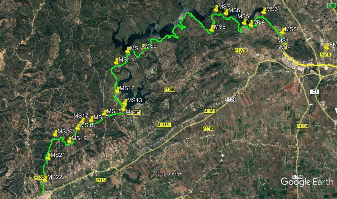
Having crossed the railway at the end of the previous section (MS1), turn right and walk along the tarmac road, down into a hollow and up again, for 450m. Take the narrow tarmac lane on the right (cul de sac sign) and walk uphill. Pass a farm track on the left, and after 360m, where the road bends to the right, cut away from the tarmac at an acute angle to the left, following an indistinct track just west of north, with a small dam or barragem down to the left.(MS2) Make for the top of the rise ahead, and as the track turns more northwesterly, join a much clearer track from the left, coming up from the barragem. Now follow the ridge line for 1.4k. Come to a point where you can see twin barragems below on the left, and swing round to the left above them, taking the left hand at a fork. (MS3).
With the huge Barragem de Funcho now in view ahead (if the weather has been dry for a while, the water level may be much lower than it appears on the photo), descend on this track to join a wider track after 340m, and turn left, with barragems both left and right. Walk almost due south for 440m, dropping down to a tarmac road. Turn right and walk round the curve and uphill over a rise for 330m, to arrive at a T junction with another tarmac road. (Just along to the right here is a car park, so you could start the stage from here.). Turn left and walk down the road for just over 100m. Now drop down on the right to a track heading almost due south. (MS4). After 100m, swing round in a hairpin to the right, and climb up on a track which divides scrub from land which has been ploughed and planted.
Reach the ridge after around 250m and turn left. After 220m, find a track leading down on the right. (MS5). If the water level is low, you can go down here, turning left halfway down, to cross the valley at the bottom. Otherwise, go straight on for another 330m to a cross-tracks and turn right. Descend on this track for around 500m, to arrive at level ground close to the barragem. (this is where you would get to from (MS5). Now follow this very wide and clear dirt road as it winds around the foot of the hills. Pass a house on the right after around 500m, and soon afterwards begin to climb. Stay right at a junction after 300m, and right again at a fork after another 350m. (MS6) Round two sharp bends, keep heading northwest, parallel with the barragem, for around 260m, descending a little, then swing west and start to climb again, quite steeply.
The way is winding, but the general westward trend is consistent. passing multiple tracks heading off on both sides. After 450m from the turn west arrive at a saddle, with tracks going off uphill on either side. (MS7). Now swing round the hill to face southwest and walk on undulating ground for 200m, then curve round to a more southeasterly direction for another 400m, passing one cross-tracks on the way. From here turn west then south and start to descend, arriving at a complex track junction. Take the track straight across, heading southwesterly, and walk downhill now almost due south, for around 430m, to join a wide dirt road at the bottom. (MS8).
Turn right. The next part of the walk is a 7k trek above the shore of the Barragem de Funcho, and a climb out at the end. This involves winding round several large inlets which can be frustrating at the time, but the vast bulk of the distance is flat. Do not turn away from the water until after passing the houses at the far end. Then walk uphill, passing the deserted hamlet of Funcho de Diante on the right, and finally emerge at a tarmac road (MS9). This is the point at which you could break off, if you have a support vehicle. To continue, turn right and walk for 330m, to find another tarmac road on the right. Descend on this all the way down to the wall of the Barragem, and walk across. Immediately take the left hand at a fork, (MS10) and descend further, walking down to the valley under the dam.
Do not cross the river bed at the bottom, but turn right before it. You are now walking alongside the tail of the Barragem do Arade. After 870m, stay on the valley floor (left) at a fork (Here the Via Algarviana takes a different route, see the red and white marker). (MS11) Around 1.6k further on, pass orchards and a house on the left, and take the track after this at a fork, heading uphill on the right. (MS12) Follow as it curves above the end of a long thin barragem, and rises to a junction with a track coming down from the right, with gateposts either side. Go straight ahead for 430m, to a point quite close to the shore of the barragem on the left, (MS13) and turn right on a track which goes west for a short distance before turning sharp left to head due south. Take the second track on the right and immediately fork left to walk down a footpath into the valley.
NOTE (February 2022) A great deal of forestry work has been going on between point MS15 and the end of the stage, with many new tracks being opened up by tractors, and existing ones widened. Take care to stay on the indicated tracks, as many of the new ones are cul de sacs intended for planting and clearing. If you are at all worried about this, you can walk round from Point 13 to the dam wall and from there descend the road leading from it and follow the levada (irrigation channel) all the way to Silves.
At the bottom after 200m, swing sharp right round a pond, and at a fork very soon take the left hand option (MS14). The path runs along the valley floor, and due west for just over 500m, then it turns a litttle south of west. Always stay on the right hand side of the stream bed. Stay left in the valley at all forks, and go straight across at a cross-tracks after another 550m. (MS15) After a further 800m, come to an open area at a cross-tracks, where the land rises left and right. (MS16). Go straight across and descend very gently. Fork right after 100m, and continue on a winding path through trees, soon starting to rise. A track joins from the right after 540m, (MS17) but go straight on and round a wide left hand bend, descending now, to come to a cross-tracks. Go straight across and climb gently to another junction after 260m (MS18).
Take the first right and continue to climb just west of south for another 370m, Where the track turns very briefly west, pass a turn on the left, and immediately take the left at a fork. Over the next 500m, the track heads first south, then curves round to just south of west, and finally a short distance southwest to another junction. (MS19). Turn sharp right here and after 160m, turn right again at a junction. Over the next 430m, the track drops down, heading generally north, then start to rise gently. Now turning due west, it runs on more or less level ground for a further 500m. Now find a turn on the left running southwest just to the left of an open area (MS20) (you can see that this path cuts off a corner, as the main track runs on the far side of this open land).
The path rises to a junction. Turn left, to head just west of south on a wide track. Stay left after 330m, and at a fork after another 800m take the right hand. (MS21). Stay left after 300m, and follow the track due south, to end up walking down a long hill with the town of Silves and its castle ahead. Reaching the valley floor, bear right to cross the stream (MS22) and head up to a tarmac road. Turn left and walk up to the crest, where you will see a narrow water channel running under the road. This is the end of the stage. Carry on down the road into Silves, or turn right along the side of the channel to continue (see Stage Seven.)
NOTE: If you have energy left, you may like to walk a short distance to visit a plaque dedicated to the memory of Maurice Clyde, who was the chief founder of the original Algarve Way. To do this, when you have crossed the river at MS22, turn right and walk along the valley for 400m. Now turn left and climb up to a tarmac road. Turn right and shortly see a bridge ahead. Walk to the far end of the bridge to see the plaque on the left. To finish the stage, simply turn round and walk along the road, past the levada after 1k, and into Silves near the castle after a further 700m.
GPS Points (37/8)
| 1 | Railway | 15 | 58 | 42 | 18 | 06 | 82 | |||
| 2 | Fork left off road | 16 | 08 | 39 | 17 | 41 | 83 | 820m | ||
| 3 | Fork left | 16 | 41 | 77 | 18 | 19 | 41 | 1.44k | ||
| 4 | Fork right | 16 | 21 | 54 | 18 | 45 | 53 | 1.22k | ||
| 5 | Short cut right | 16 | 24 | 60 | 18 | 59 | 80 | 520m | ||
| 6 | Fork right | 16 | 40 | 85 | 19 | 36 | 82 | 1.98k | ||
| 7 | 2nd left | 16 | 46 | 70 | 19 | 57 | 73 | 790m | ||
| 8 | Sharp right | 16 | 14 | 34 | 20 | 06 | 84 | 1.24k | ||
| 9 | Turn right | 15 | 44 | 85 | 22 | 28 | 70 | 7.74k | ||
| 10 | Fork left | 15 | 41 | 36 | 23 | 00 | 15 | 1.6k | ||
| 11 | Stay left | 15 | 23 | 14 | 23 | 23 | 81 | 1.11k | ||
| 12 | Fork right | 14 | 36 | 45 | 23 | 22 | 37 | 1.63k | ||
| 13 | Hairpin right | 14 | 16 | 40 | 23 | 07 | 02 | 920m | ||
| 14 | Fork left | 14 | 07 | 03 | 23 | 10 | 92 | 480m | ||
| 15 | 2nd left | 13 | 59 | 21 | 23 | 49 | 98 | 1.1k | ||
| 16 | Turn right | 13 | 49 | 39 | 24 | 16 | 56 | 820m | ||
| 17 | Bear left | 13 | 46 | 73 | 25 | 35 | 69 | 620m | ||
| 18 | Bear right | 13 | 37 | 16 | 24 | 44 | 42 | 540m | ||
| 19 | Sharp right | 13 | 15 | 87 | 25 | 02 | 01 | 880m | ||
| 20 | Turn left | 13 | 27 | 37 | 25 | 30 | 95 | 1.11k | ||
| 21 | Fork right | 12 | 48 | 97 | 25 | 46 | 25 | 1.37k | ||
| 22 | Cross stream | 12 | 12 | 34 | 25 | 54 | 72 | 1.24k | ||
| Levada (end) | 11 | 56 | 14 | 25 | 59 | 69 | 540m |
The Maurice Clyde Memorial Plaque is at: 12.26.47 // 26. 07. 28