Walk Nine. Algarve Way Stage 5
Benafim to Sao Bartolomeu de Messines. 21.8k. Ascent: 440m
Introduction.
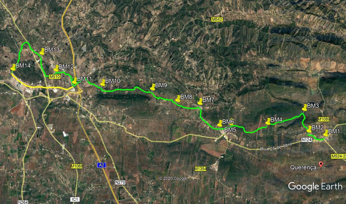
This fifth stage is probably the easiest of all, both in terms of length and difficulty. From Benafim, the route climbs over a modest hill to descend to the pretty tourist village of Alte, which you can visit, but the route itself avoids the centre. Another shortish climb takes you up to the small settlement of Santa Margarida, where you have an excellent view over the terrain to come. From there the way is all either downhill or on level ground, crossing some somewhat disappointing territory to circumvent the town of Messines and complete the stage at its western outskirts. Alternatively, you can walk straight through Messines, though this is of course much more built-up and totally tarmac. The general direction today is just north of west. The yellow line on the photo shows the route through Messines.
Directions
Getting to Benafim.
From Barranco do Velho, use the N124 past Salir and Pena.
From the south, leave the motorway at Boliqueime, and follow signs to loule. Past the quarry turn left, and at the T junction in Parragil turn left again. Now follow this road down into a valley and back out again, Pass through Ribeira de Algibre and Alto Fica. Reaching the N124 at Benafim, turn right for the rendevous cafe.
By vehicle to Messines.
Turn left at the roundabout in Benafim and follow the N124 through Alte. Reaching the motorway junction outside Messines, turn left and follow the Messines bypass to the far side of the town. Having gone round two more roundabouts, come down a long hill and take a sharp right back towards Messines. Cross the railway line and then take the first left. Follow this road a short distance to the railway crossing which is the rendevous point.
The Walk.
From the cafe near the roundabout in Benafim, (BM1 ) walk past the roundabout and take the first road on the right, a narrow way leaving the main road at an acute angle. The road heads roughly west for 360m, then turns north. From here take the first turn on the left, and almost immediately cross over a road running north/south, and into the Rua da Igreja. Now follow this equally narrow road as it curves northwards and then begins to leave the village behind. Walk straight on past the village church on the left, past a turning to the right, and 130m beyond this find a narrow pathway entrance on the right.(BM2) Follow this over a rise and down to a junction with a road at a bend. Go straight ahead, northwards, for just over 500m, and stay right at a junction. Now follow what is a track downhill into a valley, arriving at a junction in the bottom after another 500m (BM3).
Turn left. Now begin a long, steady climb, roughly southwesterly, with views opening out as you go. Later in the section, as the incline levels out, the track turns into a tarmac surface, and soon turns south. After 2.1k, come to a junction and turn right (BM4). The surface turns into a track once more, and descends over 830m to join another track coming in from the left. Bear right here and continue to descend gently. After 870m, the track becomes paved, and buildings begin. Pass a cafe on the left and tiered seating up on the right. Round a wide left hand bend come to another restaurant on the left, and immediately opposite find a narrow overgrown track heading off uphill. (BM5).
Follow this just south of west in a straight line for 200m, emerging at a tarmac road. Turn right, and after 100m, hairpin left at a junction. Walk for just over 450m, and then take a wide dirt track heading uphill on the right.(BM6). Follow this as it levels out, passing by all turns to the left. After 950m, come down a short slope to join a main road, and turn right. Walk along past a cafe on the right and into the village of Santa Margarida. Take the second turn on the left (the first is a house drive) (BM7), and walk downhill. Walk broadly westwards for 1.14k, passing turns to left and right, and at a fork (BM8) take the right hand. Continue for another 1.1k, now more north of west, staying on the broad valley floor. At the end of this section, the track turns sharply south for a short distance to a junction. Turn right and walk uphill now, northwesterly, for 470m, to a fork by a house on the right. (BM9).
This time take the left hand option and start to descend steadily. Walk down the valley for 2.7k, staying right at a junction after almost 1k. Arrive at a tarmac road in the tiny settlement of Vale, and turn left (BM10). Walk along the road for 600m, then turn right on a track across open land northwest for 400m to another road. Turn left and walk for juast over 700m, under the motorway, and find a track on the right opposite a large electricity distribution station. (BM11). (You are now on the outskirts of Messines. If you want to visit the town, walk straight ahead, and to rejoin the route keep going on the same line right through the town to the railway, a distance of 3.4k from this point.)
To continue, walk for 200m, almost due north, and take the left hand at a fork. Now head towards a large industrial building. After 460m, veer left round a small pond, and make for the corner of the industrial site. At the fence turn left and head due west towards the left hand end of Campilhos, the village ahead. Go over a rise and drop down onto a tarmac road just left of the first houses.(BM12). Cross the road and take the road opposite, rising up and over a short climb. After 450m, with a main road in sight, take the right at a junction and walk parallel to the main road (the IC1). Pass buildings on the right, and veer away from the road to pass an industrial site on the left. Arrive at a fork and take the left hand option. (BM13).
This brings you down to the main road. Turn right and walk along the side of the road. This is one of the busiest roads in the Algarve, so take care, and cross when you can. After just over 300m, take a dirt track on the left, and follow this as it swings round in a wide curve to end up facing southwest. Pass a turn to the right and one to the left, and after 850m, join a track coming in from the right. Now walk forward to join the line of the main line railway heading into Messines. After the first group of houses, find a short lane leading to a crossing of the railway. (BM14)This is the end of the stage.
GPS Points (37/8)
| 1 | Benafim | 13 | 59 | 63 | 07 | 16 | 58 | |||
| 2 | Turn right | 14 | 05 | 57 | 07 | 49 | 60 | 910m | ||
| 3 | Turn left | 14 | 39 | 76 | 07 | 57 | 05 | 1.24k | ||
| 4 | Turn right | 14 | 17 | 81 | 09 | 10 | 17 | 2.1k | ||
| 5 | Fork right | 14 | 17 | 02 | 10 | 22 | 41 | 2.1k | ||
| 6 | Turn right | 14 | 14 | 67 | 10 | 45 | 07 | 740m | ||
| 7 | Turn left | 14 | 49 | 17 | 11 | 24 | 03 | 1.6k | ||
| 8 | Fork right | 14 | 53 | 73 | 12 | 07 | 79 | 1.13k | ||
| 9 | Fork lerft | 15 | 11 | 98 | 12 | 57 | 71 | 1.55k | ||
| 10 | Turn left | 15 | 19 | 22 | 14 | 37 | 97 | 2.7k | ||
| 11 | Turn right | 15 | 22 | 30 | 15 | 34 | 73 | 1.74k | ||
| 12 | Cross road | 15 | 42 | 09 | 16 | 11 | 68 | 1.45k | ||
| 13 | Fork left | 16 | 09 | 30 | 16 | 41 | 04 | 1.48k | ||
| 14 | Railway | 15 | 58 | 42 | 18 | 06 | 82 | 2.92k | ||