Walk Ten. Algarve Way Stage Four. Barranco do Velho to Benafim. 22.5k Ascent: 588m
Introduction.
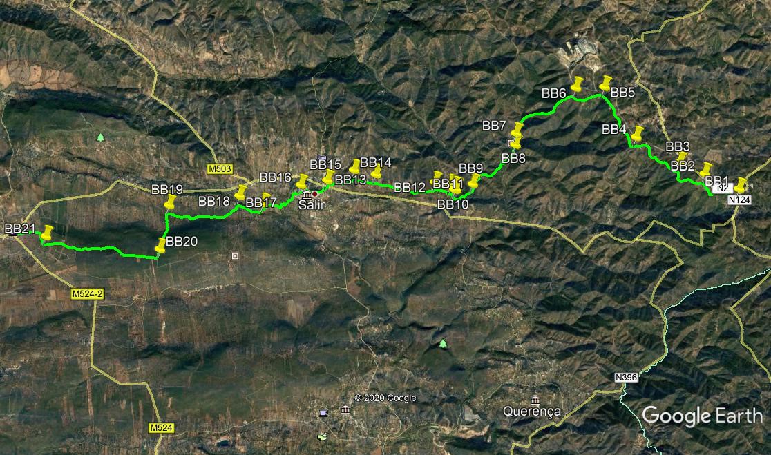
After the exertions of the third stage, the fourth day is very different. Starting with an undulating stroll along the edge of the eastern plateau, with magificent views westward, the walk descends to the small market town of Salir, and from there over a modest hill to Benafim. Some walkers may be tempted to continue to Alte, but this makes for problems with the distancing of subsequent stages. There is far more evidence of human population from now on, but the route manages to steer clear of most of it, save for the walk through Salir, where most services can be found. In contrast to the previous day, most of the route this time is either on level ground or descending. The first five k takes you northwest, followed by the descent from the plateau, which heads southwesterly. The rest of the day follows a more direct route west. In the course of the day, the GPS system takes you from the 37/7 `square´to the 37/8.
Directions
Getting to Barranco.
From Ribeira, drive north-west to Cachopo on the 397, and then turn left along the 124 for Barranco via Feiteira and Montes Novos. The whole journey is about 34k, but on very winding roads.
From the south, leave the motorway at junction 5 and take the N2 for Sao Bras and Almodovar. Barranco is about 20k from the motorway, and the junction with the 124 road for Cachopo is your rendezvous point, outside the Tia Bia Pensao and Restaurante.
By vehicle to Benafim.
Drive west along the 124 past Salir and Pena. Your rendezvous is before Benafim proper, at a roundabout with cafes on both sides of the road.
The Walk.
With your back to the Tia Bia, (BB1) cross the road and walk up the lane opposite. Come to a gate (possibly the only gate on the whole Algarve Way!) and go through, passing to the left of large buildings, including the church. Note the view becoming available on the left. 160m beyond the church look to the right to see the main road, but turn left to continue on the wide track. Pass a turn to the left after 330m, and another 400m further on, turn left at a junction with another track leading down to the road on the right. (BB2). After 800m, stay left once more as yet another track goes off to the right. (BB3).After 1.35k, passing another short track linking to the main road on the right, and another on the left heading over to an ´alternative´settlement, come to a cross-tracks in a hollow. (BB4). Go straight across, swing right, and walk up to a restored windmill base. Walk pást, and continue on more or less level ground for almost 1.2k, passing minor tracks left and right, but maintaining the general northwestward trend. Come to a steep descent through trees, and emerge at an open space close to the main road. (BB5).
Take the track on the left closest to the road, and start to descend. 720m on, take the left hand at a fork and continue to go downhill. (BB6). Walk down to the valley floor, 1.85k away. At a junction, with buildings ahead and right, stay left (BB7). Pass one turn back to the houses on the right, and after 300m, take a track heading off at an acute angle across a stream or dry bed, heading south west.(BB8). Climb the slope and go straight on at a junction after 470m, and again at a staggered cross-tracks after another 220m. Descending gently now, the track turns west for a while, and then at a fork take the left hand and turn more southerly. 550m from the fork, meet another track coming in from the left, and go straight on, still descending (BB9). The track levels out after around 500m (BB10). Bear round to the right at an open area, and find a fording place across a stream or dry bed. Cross over.
Pass a ruined mill on the left, and at a fork take the right hand, gently uphill. After 100m, turn sharp left, and another 100m+ further on, take the second right, heading northwest. (BB11). At the top of the rise, pass a drive to a house on the right, and an old farm on the left. Go straight ahead and follow a rough track down into a hollow and up the other side, through another dip and up to a cross-tracks, with a house up to the right. (BB12). Go straight on once more, gently downhill, westwards all the time. Pass an area of bare earth and walk through to the junction with a narrow tarmac road after 600m. Stay right up this road, and follow it for 800m, passing one or two houses along the way. Arrive at a house on a corner (BB13), and go straight across into a narrow lane up a short slope. Follow this between buildings, and where the paved road turns left, go straight on between an old barn on one side and polytunnels on the other. Cross over a stretch of heath, climbing gently, to come back to the paved road. Stay right, wind between houses, and down into a hollow. On the way up the next rise, quite close to the next houses, take the second track on the left. (BB14).
Go down the track and follow as it turns right to wander across the valley. Go straight across at a cross-tracks with a large building on the left, and walk for 330m more to reach a tarmac road. Turn left and walk up to a wider main road. Turn right and then cross and take the first left, uphill. Take the first right up a steep narrow lane (BB15). Where it joins a wider road, stay right and climb to the top, which is the church square of Salir. Refreshments may usually be had at the tapas bar on the left. To continue, turn right and walk down the narrow street. After 260m, as the road starts to climb again, take the left hand at a crossroads. At the next junction, in the middle of Salir, more refreshments, turn right and walk for 180m, round a wide left hand bend. Past a large two storey house find a narrow paved lane on the right (BB16), and walk down to another main road. Go across and find stone steps over the wall on the other side. At the bottom go straight ahead, leaving a workshop on the right. After 100m bear right with the lane, and stay left almost immediately at a junction. Now follow the lane down into the valley.
Swing right past a set of gates at the bottom, and follow the lane across the floor of the valley, passing several old wells. After 550m come to a group of houses and turn right.(BB17). Almost immediately go straight across at a crossroads and walk into the village of Almarginho. After almost 600m, see a bank of postboxes against a wall on the left, and take the narrow lane on the left just afterwards (BB18). Follow the lane as it turns into a track and slowly curves round to head westwards, with scrub on the right and views over cultivated land on the left. Now follow this track due west for around 1.8k from the turn by the postboxes. Arrive at a junction with a clear track on the left, heading due south in a straight line. (BB19). Turn along here and cross the valley floor. Follow as it climbs for 700m up the hill on the far side, to reach a junction as the land levels out. (BB20). Turn right and follow this track west over a broad plateau for just over 2.2k, to reach the edge of large orange groves. The track runs along the edge of the groves, turning sharp right at one corner, (BB21) then sharp left away from the trees to head west again down to the main road on the outskirts of Benafim. Turn right the main road and right again at the roundabout soon afterwards, to find refreshments. This is the end of Stage 4.
GPS Points. (37/7/8)
| 1 | Barranco do Velho | 14 | 24 | 38 | 56 | 14 | 40 | |||
| 2 | Turn left | 14 | 35 | 37 | 56 | 45 | 35 | 1k | ||
| 3 | Stay left | 14 | 43 | 62 | 57 | 08 | 05 | 800m | ||
| 4 | Cross tracks | 15 | 02 | 05 | 57 | 47 | 62 | 1.34k | ||
| 5 | Junction 2nd left | 15 | 38 | 68 | 58 | 15 | 75 | 1.46k | ||
| 6 | Fork left | 15 | 37 | 84 | 58 | 42 | 25 | 730m | ||
| 7 | Bear left | 15 | 06 | 00 | 59 | 34 | 89 | 1.9k | ||
| 8 | Right across stream | 14 | 57 | 46 | 59 | 35 | 43 | 320m | ||
| 9 | Stay right | 14 | 28 | 62 | 00 | 14 | 84 | 1.5k | ||
| 10 | Right to stream | 14 | 23 | 59 | 00 | 31 | 53 | 490m | ||
| 11 | Turn right | 14 | 28 | 03 | 00 | 35 | 47 | 300m | ||
| 12 | Cross tracks | 14 | 30 | 08 | 00 | 49 | 71 | 400m | ||
| 13 | narrow passage | 14 | 35 | 75 | 01 | 44 | 40 | 1.43k | ||
| 14 | Turn left | 14 | 39 | 00 | 02 | 04 | 57 | 530m | ||
| 15 | Fork right | 14 | 31 | 24 | 02 | 29 | 31 | 840m | ||
| 16 | Turn right | 14 | 27 | 75 | 02 | 53 | 93 | 740m | ||
| 17 | Turn right | 14 | 13 | 75 | 03 | 29 | 10 | 1.22k | ||
| 18 | Turn left | 14 | 19 | 57 | 03 | 50 | 83 | 540m | ||
| 19 | Turn left | 14 | 12 | 64 | 04 | 55 | 52 | 1.85k | ||
| 20 | Turn right | 13 | 40 | 52 | 05 | 02 | 37 | 1.1k | ||
| 21 | Turn right | 13 | 49 | 48 | 06 | 48 | 72 | 2.72k | ||
| Benafim | 13 | 59 | 63 | 07 | 16 | 58 |