Walk Sixteen. Algarve Way Stage Three.
Monte de Ribeira to Barranco do Velho. 27.5k. Ascent: 1280m
Introduction.
This third stage, although slightly shorter than the previous one, is one of the hardest on the crossing, mainly because of the hilly nature of the terrain. Anyone not used to this kind of hill walking, or carrying a full pack, would be wise to consider breaking the trek at Castelao, and either walking or getting a lift the 3k to where accommodation may be had, or a lift to it.. The stage is certainly the most interesting so far, and by the end of it you will have finished with the sparsely populated eastern part of the walk. From now on, supplies, accommodation and assistance will be far more readily available. Direction today starts off not far south of west. Beyond RB7 it turns decisively southwest, and then after Parizes it becomes more westerly again.
Directions.
Getting to Monte de Ribeira.
The quickest way is to use the N397 north from the motorway at Tavira.
By vehicle to Barranco do Velho.
Drive north from Ribeira to the junction with the N124. Turn left and drive on the winding road to Barranco.
The Walk.
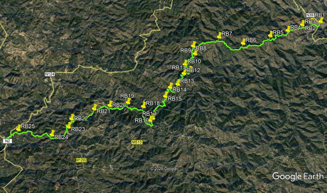
Start from the point at which you came out onto the main road at the end of Stage 2. Cross the road (RB1) and take the lane leading off southwest, at an acute angle to the main road. After 180m, turn right on a track heading northwest, and another 170m further on, turn left and face southwest again. Now begin a long steady climb. Stay right at a fork after 290m, (RB2)and soon meet a track coming in from the left. Walk first southwest and then broadly west for 560m, ignoring a track on the right after 220m. Stay right again at a fork (RB3)and walk just south of west, still climbing. Pass a lane on the right after 450m, and after another 190m, pass a turn to the left and then immediately turn sharp left at a junction. Walking now south to southwest, pass a turn to the right after 120m, and walk on, now on more level ground, for another 230m to reach a cross-tracks with a small group of houses on the left.(RB4)
Go straight across and then swing round to the right to walk due west. Now the climb resumes, over the next 1.47k, staying right at a fork after just 150m. At the end of this stretch, come to a point with a track going off right and another just beyond it going acutely left. (RB5) Go straight ahead here and start to descend, still broadly southwest. After 450m, turn due south for a short distance. Go past a cross-tracks, and at a fork immediately afterwards, take the right hand. Starting to climb again, soon turn due west for 630m, (you are walking a ridge line here) then more southwest again for 230m, taking the right at a fork and soon coming to a cross tracks. (RB6). Go straight across and turn southwards, passing a couple of tracks going north. The climb continues over the next section, gently at first. After 640m, stay left at a junction and then climb northwestwards for almost 950m to a high point at a junction. (RB7). Stay left, and turn to south of west, starting to descend very gently. Stick to the ridge, and walk for 1.5k, turning due south just before the end to reach a fork (RB8).
Turn left and walk downhill for just under 500m, passing a cross-tracks near the end, then swinging east momentarily, to a junction. (RB9). Turn right through a hairpin bend here, and soon head roughly southwest once more. still desending. Go left at a hairpin after 350m, left again after another 450m, and right after another 350m. Soon turn sharp left (RB10) to the bottom of a valley (maybe wet in winter), and start to climb again. Fork right almost immediately, and walk around 270m southeast, followed by 170m due south, to a junction. (RB11). Turn right through a hairpin bend and continue to climb. Stay left at a fork after 430m, and reach a junction after another 320m. Turn right here and walk uphill to the next junction, 400m away, turn left and walk alomg a road another 260m up to the hamlet of Castelao. (RB13). (This is where you need to decide whether to go on or break the journey, see the notes.)
To continue, take the first turn right in the hamlet, and walk just north of west, well past the last houses and ruins, before turning almost due south. on a wide right hand bend, pass a turning to the left before swinging round northwest and then due west, to reach a hairpin left, 850m from Castelao. After 160m, swing round sharply right, ignoring a turn to the right at the crown of the bend.(RB14). Now walk first southeast then due south for 750m over undulating ground. Pass a turn to the left after 330m, and go straight on at a cross tracks after another 280m. Soon after this take the left hand at a fork (RB15). Walk south for 400m, then turn roughly west for another 400 before turing sharply left to go south once more. Pass a turn to the left after 260m, then continue, climbing now, for 950m, before taking the right hand at a fork (RB16), and walking up into the village of Parizes. here again is an opportunity to call it a day, as your support party could pick you up.
Turn right at the tarmac road, and right again at the first opportunity. Walk along the narrow village road (there is a small bar on the right), taking the left hand at two forks close together. From the second one (RB17), pass out of the village and start a long descent. Pass a cross-tracks after 400m, and reach a fork after another 540m. Take the left hand (RB18) and continue to descend, more westerly, for almost 1k. At another fork, take the left again (RB19), and do the same a few metres further on. After 1.2k, on more or less level ground, on the obvious main track heading mostly due west, come to yet another fork and this time go right (RB20). After walking northwest for almost 300m, swing round to southwest and continue, sometimes rising, sometimes level, for another 800m. Pass a hairpin turn on the right and a turn to the left (RB21), and continue southwest or westerly for 1.6k, rising gently at first but becoming steeper. Meet a track coming in from the right, (RB22), and continue ahead to a junction on a ridge, with a wide view west.
Turn left and avoiding minor turns right, take the right hand at a fork after 300m. (RB23) (see a barragem down to the left on this short section). Walk along for 360m, southwards, to reach a tarmac road. Turn right and walk downhill. After 570m, pass a wide dirt track on the right, and after another 200m find a less obvious right turn, heading up into the scrub.(RB24) Follow this track northwest for around 380m, when it turns westerly.Soon after the turn, pass a downward track on the right, and after almost 700m pass a steep downhill on the left. The route now swings more northerly again for a couple of hundred metres before resuming the westward trend. 800 metres from thus turn come to a junction (RB25) and turn right. Walk round a left hand curve and arrive after around 250m at the car park of a large community building. Continue past the building to a main road and turn left. From here walk along the road to a major junction, with the Tia Bia Restaurant and accommodation on the left. This is Barranco do Velho, and the end of the stage.
GPS Points. (37/7)
| 1 | Monte de Ribeira | 17 | 50 | 74 | 45 | 06 | 22 | |||
| 2 | Cross diaginally | 17 | 48 | 24 | 45 | 28 | 37 | 660m | ||
| 3 | Cross tracks | 17 | 44 | 06 | 45 | 47 | 73 | 560m | ||
| 4 | Cross tracks | 17 | 33 | 10 | 46 | 19 | 92 | 1.15k | ||
| 5 | Stay right | 17 | 22 | 89 | 46 | 59 | 33 | 1.47k | ||
| 6 | Stay right | 17 | 08 | 54 | 47 | 58 | 52 | 1.77k | ||
| 7 | Stay left | 17 | 18 | 33 | 48 | 50 | 23 | 1.56k | ||
| 8 | Turn left | 17 | 02 | 46 | 49 | 44 | 93 | 1.57k | ||
| 9 | Hairpin right | 16 | 49 | 50 | 49 | 40 | 98 | 490m | ||
| 10 | Sharp left | 16 | 31 | 52 | 50 | 01 | 66 | 1.37k | ||
| 11 | Hairpin right | 16 | 20 | 54 | 49 | 51 | 44 | 560m | ||
| 12 | Turn right | 16 | 15 | 59 | 50 | 03 | 79 | 730m | ||
| 13 | Turn right | 15 | 57 | 09 | 50 | 16 | 69 | 750m | ||
| 14 | Stay left | 15 | 51 | 61 | 50 | 32 | 81 | 1k | ||
| 15 | Turn left | 15 | 36 | 21 | 50 | 42 | 85 | 770m | ||
| 16 | Fork right | 14 | 59 | 05 | 51 | 08 | 63 | 2k | ||
| 17 | Fork left | 14 | 55 | 15 | 51 | 14 | 26 | 430m | ||
| 18 | Fork left | 15 | 18 | 38 | 51 | 28 | 99 | 930m | ||
| 19 | Fork left | 15 | 24 | 58 | 52 | 02 | 46 | 980m | ||
| 20 | Stay right | 15 | 19 | 29 | 52 | 40 | 98 | 1.19k | ||
| 21 | Stay left | 15 | 12 | 97 | 53 | 13 | 75 | 1.1k | ||
| 22 | Turn left | 14 | 55 | 39 | 54 | 00 | 19 | 1.6k | ||
| 23 | Turn right | 14 | 41 | 96 | 54 | 05 | 83 | 560m | ||
| 24 | Turn right off t´mac | 14 | 28 | 04 | 54 | 41 | 62 | 1.13k | ||
| 25 | Bear right | 14 | 36 | 16 | 55 | 51 | 40 | 2.2k | ||
| Barranco do Velho | 14 | 24 | 38 | 56 | 14 | 40 | 880m |