Walk Seventeen. Algarve Way Stage 2. Soudes to Monte de Ribeira. 29.5k Ascent: 960m
Introduction.
Day Two of the Algarve Way begins in very much the same way as Day One, with walking across the eastern plateau, but the trail becomes rather more challenging in the later stages, after the small town of Vacqueiros, which is the largest settlement you will have seen so far since Alcoutim. You could break the stage at Vaqueiros if you wish. There is limited accommodation. As far as the route is concerned, you could walk along the tarmac road from Soudes to Zambujal and save a little time, but the prescribed path avoids the road as far as possible, which so many walkers seem to prefer, even though the road is very quiet. Direction of march varies a good deal on this section. Starting off due west, after Zambujal the trail goes forst northwest and then southwest. After Vaqueiros, the trend is sue south to Monte de Ribeira.
Directions.
Getting to Soudes
Leave Alcoutim on the Martim Longo/Cachopo road (124). Turn left down the 122 (IC27) after 6k, and right towards Zambujal after another 13k, on the 505. Soudes is 9k along. The distinctive windmill is your best landmark.
Coming from the south, take the IC27 from Castro Marim or the motorway, and drive past Azinhal and Odeleite. 4k on turn left towards Zambujal on the 505.
By Vehicle to Ribeira
Drive west from Soudes to Zambujal and continue along the 505 via Malfrades, Monchique, and Amoreira. Turn left at the junction with the 397 Tavira road. Ribeira is about 10k along, in a valley with cafes on both sides of the road. It is not marked on all road maps.
The Walk.
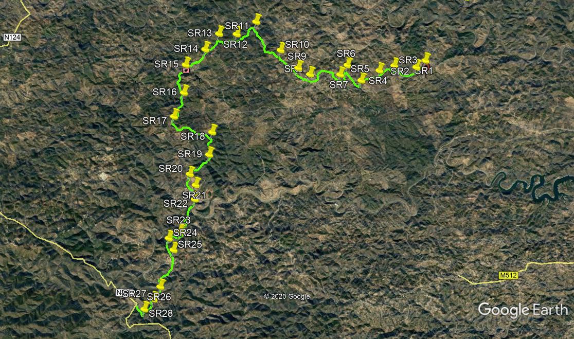
With your back to the Soudes windmill,(SR1) turn right and walk along the tarmac for just under 500m, to find a track heading off at an acute angle on the right. (SR2). After 530m, the track joins another coming in from the left, and immediately after that,take the left at a fork. After another 460m, fork right (SR3). Walk 210m just west of north, and then turn sharply left to walk now southwest for just over 600m to a cross-tracks.(SR4). Go straight across, and walk west and then more south of west to come back to the tarmac road at (SR5). Turn right and take the next turn on the right, a dirt track heading gently uphill. After almost 650m, make a hairpin turn left (SR6), and head almost due south. Turn to the west after 370m, and soon after go right at a fork, to arrive at a junction with another track on a bend.(SR7).
Turn right here and go northwest for 500m, turning left at a junction. Now follow this track as it turns through a wide arc and heads for the hamlet of Zambujal, arriving there after just under another kilometre. Turn right after the first house, and make your way west along the edge of the hamlet, avoiding turns to the right. Come to a wider junction, and turn left to walk the short distance back to the main tarmac road. Turn right and after 140m, bear right along a track leaving the main road at an acute angle. (SR8). Walk for 600m to a junction (SR9) and bear right. Take the left hand at a fork after 130m, and continue northwest for another 1k. Just after turning west, take the left hand at a fork (SR10). From here, follow this main track (there are no obvious turns) for 1.86k, northwest, to reach a deserted hamlet.
Walk between the ruins, and at a fork on the far side take the left hand. (SR11). the track now makes a wide swing to head south over the next 1.17k to arrive at a cross-tracks (SR12). Go straight across, and straight across again at a second cross tracks after 400m. Follow this main track for another 400m to come to a junction. (SR13). Turn left and head southwest for around 900m, ignoring various minor tracks on the right. At a fork (SR14), take the right hand and head for the small town of Vaqueiros, clearly visible ahead. Walk up out of the shallow valley and cross the main road to reach the centre. Turn first left and walk up to the church. There are refreshments to be had here if you will.
Cross the square diagonally into Rua da Boavista and walk uphill. Bear right at the fork and continue in the same direction, roughly southwest. Dogleg right and left to go up the Travessa do Canto. Turn left at the top and then very shortly turn right into a lane taking you southwest away from the town. (SR15). At a junction after 230m, bear left, and walk due south. At a further junction after another 230m, climbing all the way, stay right and walk south for 560m, now descending. Hit a valley floor here (SR16), and start to climb again, still heading south. After 720m, pass a track going back autely on the right, and soon after pass another one on the left. A further 410m on, come to a staggered cross-tracks and turn left. (SR17). Walk southeast for 350m to join a tarmac road, then turn off it again immediately to the left.
After 300m, pass a small barragem, with a house beyond it. Pass a track on the left going north soon after the house, and another one similarly after another 300m. After 180m, pass a track heading southwest on the right, and 660m further on, come to tarmac again. (SR18). Cross over and after 100m come to a track junction. Turn right and after just over 200m, turn right again. Now heading south again, descend steadily over 840m to a fork at (SR19). Take the right hand and continue to descend south-west over 930m, then hairpin left to turn south again. Pass a rough track on the left after 250m, and soon after join a track coming in from the right. (SR20). continue southwards and join a tarmac road again after 330m.
Turn left and pass a small settlement (Madeiras) up on the left. Cross the river at the junction on the low concrete bridge, and stay right at a fork immediately afterwards (SR21). Walk south once again, with the river on the left, to reach a junction after 620m. (SR22). Fork right here, and after 210m, turn left at a cross tracks. After 460m, go left at a fork. At the next junction, after 260m, go straight across, heading roughly southwest, and then south again over undulating ground, for 650m, reaching a turn on the right heading northwest.(SR23). Turn here and after 240m, turn sharp left at a junction. Walk steadily downhill over the next 500m, first southwest then due south to reach a junction.(SR24). Turn left and walk uphill for 520m to a fork, with the village of Azinhosa up on the right. (SR25).
Stay left, and bear right at a junction almost immediately. Walk south through a small group of houses, and continue due south for 310m, ignoring turns to left and right. The broad track now turns more southwesterly. Pass a track on the left after 350m, and at a fork after another 250m, take the left hand. follow a winding track with a hill to the left and a view down to a river on the right. At the end of 800m, descend to a valley with a stream (or dry bed), and cross at the concrete ford. (SR26).Climb steadily from here for 520m, then hairpin left. Pass a turn to the left and after 200m, with houses above, go right at a fork (SR27) and start to descend quickly. Come to a junction in a valley after 650m, and turn right (SR28), to walk down to a main tarmac road. This is Monte de Ribeira, and the end of the stage.
GPS Points (37/7)
| 1 | Soudes | 23 | 04 | 28 | 37 | 11 | 31 | |||
| 2 | Turn off right | 22 | 55 | 43 | 37 | 26 | 57 | 480m | ||
| 3 | Fork right | 22 | 57 | 41 | 38 | 02 | 92 | 1k | ||
| 4 | Cross tracks | 22 | 50 | 85 | 38 | 27 | 80 | 830m | ||
| 5 | Turn right | 22 | 37 | 91 | 38 | 57 | 59 | 930m | ||
| 6 | T junction | 22 | 57 | 97 | 39 | 20 | 43 | 850m | ||
| 7 | Bear right | 22 | 45 | 53 | 39 | 32 | 51 | 670m | ||
| 8 | Turn right | 22 | 45 | 79 | 40 | 22 | 25 | 1.8k | ||
| 9 | Bear right | 22 | 54 | 31 | 40 | 41 | 66 | 610m | ||
| 10 | Stay left | 23 | 17 | 99 | 41 | 10 | 78 | 1.15k | ||
| 11 | Stay left | 23 | 55 | 31 | 41 | 51 | 14 | 1.86k | ||
| 12 | Cross tracks | 23 | 39 | 09 | 42 | 23 | 40 | 1.17k | ||
| 13 | T junction | 23 | 39 | 27 | 42 | 52 | 45 | 860m | ||
| 14 | Fork right | 23 | 16 | 38 | 43 | 14 | 36 | 910m | ||
| 15 | Turn right | 22 | 58 | 25 | 43 | 47 | 23 | 1.19k | ||
| 16 | Turn right | 22 | 21 | 83 | 43 | 50 | 27 | 1.38k | ||
| 17 | Fork left | 21 | 50 | 35 | 44 | 05 | 77 | 1.23k | ||
| 18 | Cross tarmac | 21 | 29 | 81 | 43 | 03 | 31 | 1.92k | ||
| 19 | FORK RIGHT | 21 | 00 | 52 | 43 | 08 | 66 | 1.1K | ||
| 20 | Bear left | 20 | 35 | 04 | 43 | 41 | 38 | 1.45k | ||
| 21 | Fork right | 20 | 20 | 61 | 43 | 31 | 87 | 580m | ||
| 22 | Fork right | 20 | 01 | 92 | 43 | 33 | 04 | 630m | ||
| 23 | Turn right | 19 | 19 | 43 | 43 | 56 | 93 | 1.6k | ||
| 24 | Turn left | 19 | 10 | 77 | 44 | 15 | 56 | 740m | ||
| 25 | Fork left | 18 | 55 | 52 | 44 | 07 | 71 | 520m | ||
| 26 | Stay left | 18 | 07 | 25 | 44 | 29 | 50 | 1.95k | ||
| 27 | Fork right | 17 | 50 | 51 | 44 | 40 | 72 | 740m | ||
| 28 | Hairpin right | 17 | 37 | 57 | 44 | 55 | 92 | 660m | ||
| End/Ribeira | 17 | 50 | 78 | 45 | 06 | 01 | 490m |