Walk Thirteen. Algarve Way Stage One. Alcoutim to Soudes. 21.8 k
Ascent: 800m
Introduction.
When the Algarve Way was inaugurated at the end of the last century, the start point was marked by a small monument, and a ceremony took place at the site, at the junction of Rua de Dom Fernando and the road into the town centre. Today, the first marker of the Via Algarviana stands on the spot.You are welcome to start from the riverside if you want to be sure to walk the whole route, or you could even, these days, go across to Spain and take the zipwire across the Guardiana from above San Lucar. Alcoutim itelf is a pretty but rather isolated little town that has been trying hard in recent years to make itself more appealing to tourists. the zipwire has helped a great deal in this respect.
This first stage of the walk takes you from the Guadiana valley up onto the eastern plateau, and for much of the time this is where the route lies. Directional trend is southwesterly.The first half of the day is a steady climb, but after the initial haul out of Alcoutim, it is hardly noticeable. This is followed by an equally steady descent. Only at the end of the day do you descend into another river valley - the Foupana - and climb out again to the hamlet of Soudes. The way is marked by three or four small communities, but otherwise is largely through open country.
Directions
Getting to Alcoutim.
There are two main routes – a) The 124 road from the west via Salir, Barranco do
Velho and Martim Longo. This is scenic but long and winding
b) The IC27 from Castro Marim. Much quicker.
Parking. On arrival, cross the Cadavais river bridge. Covered parking bays are available on the right.
By Vehicle to Soudes.
Leave Alcoutim on the Martim Longo/Cachopo road (124). Turn left down the IC27 after 6k, and right towards Zambujal after another 13k, on the 505. Soudes is 9k along. The distinctive windmill is your best landmark.
Coming from the south, take the IC27 from Castro Marim or the motorway, and drive past Azinhal and Odeleite. 4k on turn left towards Zambujal on the 505.
The Walk.
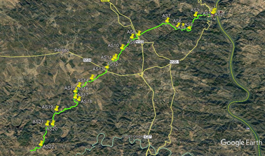
Starting from the marker post at the corner of Rua de Dom Fernando,(AS1) walk up the road southwest for around 130m. Take the first turn on the right (AS2), a narrow paved lane that takes you down to the side of a small tributary of the Guadiana. As you reach the riverbank, see a bridge across to the Alcoutim river beach on the right. Walk past this and now climb quite steeply to come back to the main road out of Alcoutim. At the road, bear right and continue to climb. Pass a small group of buildings on the left, and note the view down to the river on the right. Just under 1k after rejoining the road, find a dirt track on the left, rising away from the road. (AS3). Turn here and climb very gently over the next 1.2k, along a ridge with views down to a large dam, or barragem, on the right. Come to the first obvious turn to the right (AS4), and follow this narrow cart track as it starts to decend towards the barragem.
After 250m, the track turns left to wander round under the hill, descending at first, then rising again slowly. Stay left at a junction after around 300m, and after another 200m come to a fork. (AS5). Take the right hand track, which resumes the descent towards the water. Arrive at the valley floor, and bear left alongside the stream to reach a crossing point after around 180m. (After heavy rain, there will be water, but for much of the time this crossing is dry, or just a trickle.) Cross over and take the right hand, uphill track (AS6). Stay left at a junction with a wide dirt track, and soon come to a tarmac road, around 850m from the valley floor. Bear left along the road and come to the tiny hamlet of Corte Tabeliao. (AS7). (the road is the same one you used out of Alcoutim).
Walk around the houses on the road, and follow the roughly surfaced road as it turns to south of west and runs in a straight line for something over 2k to reach a wide main road. (This is the main IC27). Cross the road (carefully) and go through a gap to find the old road running parallel with the new one.Turn left to walk south for about 250m. Take the first turn right along a dirt track heading SW (AS8). At a fork after 550m, take the left hand track.(AS9). After a further 1.1k, fork left again. (AS10).Head southwest for another 940m and come to the hamlet of Tacoes.Turn right in front of the first houses (AS11). Walk for 100m and turn left. Then walk for 200m and take the second turn on the right (AS12). Walking just west of south, after 760m cross a main road (AS13). In the old bus shelter on this road, you may still see one of the original Alagrve Way markers in the form of a cistus flower.
Continue more southwesterly now for 1.4k to another crossing and take the track diagonally to the right.(AS14). After 270m, turn sharply left and follow the track west of south for 550m to a T junction. Turn left here to the edge of the hamlet of Fonte Zambujo de Cima. Turn right and follow the road down to the next T junction. Here turn left and very shortly see twin turns to the right. (AS15). Take the second one, heading more or less due south, and at a fork after 470m, take the left hand. (AS16). Continue due south for another 460m to reach a main road (AS17). Go straight ahead, and almost immediately fork right on a track taking you round the back of the houses of Fonte Zambujo de Baixo. Soon after leaving the houses, come to a junction and turn right. (AS18).
Now follow this winding and undulating (but generally descending) track southwestwards for the next 2k, to reach a junction at (AS19). Turn left (south) here and walk downhill to the Foupana River, around 1.2k.(AS20). Cross the river however you can (normally not a great problem) and walk west along the far bank for around 380m to (AS21).Turn left (south) with the track and begin to climb out of the valley. Walk up for 1.54k, and at a track junction turn right (AS22). After 260m, go left at a fork and continue to climb to a main road. Turn right here and walk up to the hamlet of Soudes, marked by a windmill on the right, where the stage ends.
GPS Points. (37/7)
| 1 | Alcoutim | 28 | 16 | 86 | 28 | 21 | 13 | |||
| 2 | Turn off road | 28 | 14 | 66 | 28 | 25 | 55 | 130m | ||
| 3 | Turn Left | 28 | 07 | 34 | 29 | 18 | 29 | 1.7k | ||
| 4 | Turn to valley | 27 | 52 | 32 | 29 | 21 | 12 | 1.2k | ||
| 5 | Turn right | 27 | 39 | 18 | 29 | 57 | 08 | 760m | ||
| 6 | Cross stream | 27 | 41 | 33 | 30 | 10 | 53 | 450m | ||
| 7 | Corte Tabeliao | 27 | 53 | 12 | 30 | 42 | 68 | 1.03k | ||
| 8 | At IC27 | 27 | 20 | 64 | 32 | 06 | 80 | 2.68k | ||
| 9 | ForkLeft | 27 | 13 | 85 | 32 | 27 | 05 | 552m | ||
| 10 | Fork left | 26 | 48 | 73 | 32 | 55 | 43 | 1.1k | ||
| 11 | Tacoes 1 | 26 | 26 | 10 | 33 | 15 | 58 | 941m | ||
| 12 | Tacoes 2 | 26 | 22 | 38 | 33 | 20 | 98 | 260m | ||
| 13 | Across road | 26 | 04 | 44 | 33 | 38 | 51 | 750m | ||
| 14 | Cross-tracks | 25 | 38 | 66 | 34 | 21 | 94 | 1.4k | ||
| 15 | Right off road | 25 | 20 | 76 | 34 | 58 | 76 | 1.32k | ||
| 16 | Fork left | 25 | 09 | 04 | 35 | 09 | 08 | 466m | ||
| 17 | Bear right | 24 | 54 | 99 | 35 | 08 | 71 | 460m | ||
| 18 | Turn right | 24 | 50 | 27 | 34 | 58 | 73 | 325m | ||
| 19 | Bear left | 24 | 27 | 58 | 36 | 03 | 18 | 2.07k | ||
| 20 | Foupana crossing | 23 | 54 | 54 | 36 | 13 | 93 | 1.16k | ||
| 21 | Turn left uphill | 23 | 54 | 05 | 36 | 29 | 42 | 407m | ||
| 22 | Bear right | 23 | 09 | 75 | 36 | 43 | 78 | 1.54k | ||
| Soudes | 23 | 04 | 28 | 37 | 11 | 31 | 900m |