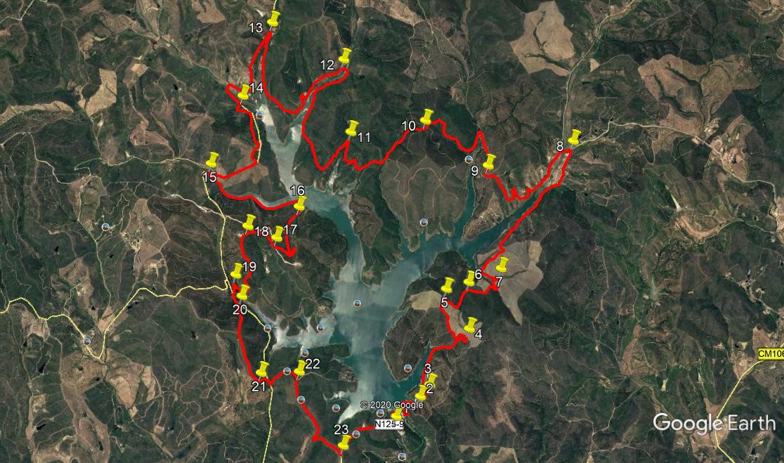
Walk Twenty One. Barragem de Bravura Circuit. 25.5 kilometres.. Ascent: 760 metres
GPS: (37/8) 12. 03. 45 41. 57. 64
The Barragem de Bravura is a large reservoir serving the west of the Algarve. It sits in the hills, and its ´fingers´ fill several valleys, radiating out from the dam at the southern end. Built in the 1960s, during the Salazar regime, it is one of several dams created in the hills of the northern Algarve since the middle of the last century. Even so, the region often faces water shortages, exacerbated by the huge influx of tourists. The walk starts at a cafe near the dam wall, and describes a route the whole way round.There are some unavoidable stretches of tarmac - unless you want to walk even further - but generally use is made of footpaths and dirt tracks.
Getting to the Barragem.
From east or west, use the A22 motorway to the junction for Mexilhoeira and Odiaxere. Turn back over the motorway and drive to the N125. Turn right, heading for Lagos and Odiaxere. At the traffic lights in the middle of Odiaxere, turn right. (Coming from the west, there is a brown sign to the Barragem.) This road, the N125-9, will take you all the way to the Barragem, almost 9 kilometres north. The road ends at a car park, with the bar at one end.
The Walk.
With your back to the cafe,(1) walk forward and take the road to the right alongside the main road you came in on, which will take you down to the dam wall. Now walk across the wall and pick up the path on the other side, leading out to a headland and back in again. Turn sharp left with the bank of the barragem (2), and follow the shore line round the next small inlet. At the head of the inlet (3) turn left, and after 100m fork left to stay close to the shore. At the head of the next inlet, which has twin ends, like horns, bear right, away from the shore and start to climb. Soon join another track coming from the right, and follow this up to a ridge at a track junction (4). Turn left and walk roughly northwest for 650m,avoiding any turns to the left, dropping a little at first, then climbing again to level ground, finally reaching a cross-tracks (5). Turn right here and walk southeast in a straight line, descending quite quickly. After 190m, swing sharply round to just east of north and walk down to another cross-tracks (6).
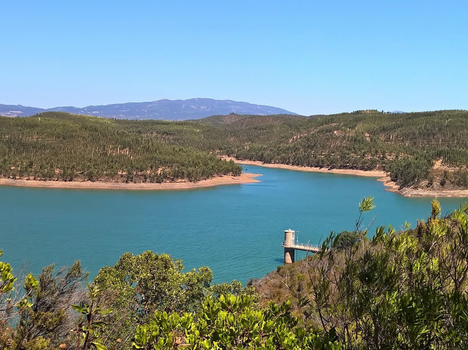
View of the Barragem near the start.
Go straight across here and turn to due east. Follow this track, more or less on level ground, for just over 400m, to reach a T junction. Turn left and go along to the head of another inlet. Turn right and then sharp left (7) to walk around it, and follow the shoreline again. Walk along to the next small inlet and turn right with the track, climbing again slowly. After 360m turn left and soon right to start a long steady descent back to the barragem, this time following the line of a large inlet. At the head of the water, continue on the same line, with a fertile valley now on the left. Pass a couple of farm buildings and arrive at a T junction (8). Turn left and soon left again to walk along the opposite side of the valley, heading back to the barragem. After almost 600m, the track begins to move away from the shoreline, passing round some buildings and winding quite a bit. Eventually the track (there is no alternative just now) turns to the northwest and climbs to a junction. Turn left, and after a few metres, swing round to the right. (9)
There are no less than four tracks leading off here. Take the left hand one, nearest to the barragem which you can see below, and follow it down to the head of another inlet. Cross over at the botton and after a few metres fork right to walk with trees on both sides, rising a little away from the water. The track soon swings more decidedly away from the barragem and climbs steadily, northwest, for around 540m. It then swings round to southwest. Ignore two tracks going off left, start to descend and coming to a fork, (10) take the right hand option and descend steadily over the next 680m. The track then turns westerly and winds for a while before turning due north to work round the head of yet another inlet. Turn sharp left at the junction (11) to head back towards the water (trees may be hampering your view of the barragem on this section). Stay on this, the only track, as it heads first southwest, then northwest to come down to the shoreline once more, and proceed to the head of the latest largeish inlet. Cross over the valley with the track, turning left and left again (12), to walk along the opposite side. This is a large ´forked´ inlet, so simply follow the track down towards the water, swing round to cross over the high point between the forks, and head back almost due north to reach the head of the second fork (13) at a tarmac road.
Turn left and walk along the road . Turn left at a junction after 1k. After a further 300m, on a very straight stretch of road, with the beginnings of water again on the left, find a track on the right. (14). Take this and follow it as it runs roughly parallel with the tarmac for around 850m, before coming back to rejoin it. (You can walk all the way on the road if you wish.) Now follow the tarmac for another 570m, to find a track on the left (15) taking you back to the waterline. Follow the track as it curves round the edge of the water, (16) and then heads uphill through trees, towards a set of wind turbines. Coming out of the trees, curve round to the left and then take a hairpin turn right to walk beneath one turbine and up, northwesterly, towards another. Come to the junction with the service road for the turbines (17) and turn right. Use the old track to pass to the left of the turbine, and then swing round in a wide semicircle to pass to the left of the third one.(18).
Now descend steeply in a southerly direction, back towards the water. See the tarmac road again across the valley, and work round the head of the inlet in front (19), to reach it. Turn right along the tarmac, and after 150m, find a track on the right heading steeply uphill. Follow this up, over and down again to come to a junction with a dirt road. (21). Turn left and walk a short distance back to the tarmac. (once again, you can walk this along the tarmac to avoid the hill if you wish). Turn right and then first left off the tarmac, and follow this track as is rises very gently. After 230m, it swings right to climb more steeply to a junction.(22). Go diagonally across here to follow a track heading east of south and then southeast, with the water of the barragam down to the left. At a junction after 770m, turn left to walk along to the tarmac once more.(23). Turn left to walk the final 800m back to the cafe and your car.
GPS Points. (37/8)
| 1 | Cafe | 12 | 03 | 45 | 41 | 57 | 64 | |||
| 2 | Fork left | 12 | 11 | 43 | 41 | 46 | 96 | 750m | ||
| 3 | Bear left | 12 | 16 | 11 | 41 | 42 | 99 | 200m | ||
| 4 | Turn left | 12 | 38 | 63 | 41 | 26 | 90 | 1k | ||
| 5 | Turn right | 12 | 52 | 69 | 41 | 39 | 28 | 650m | ||
| 6 | Curve right | 12 | 55 | 85 | 41 | 28 | 71 | 430m | ||
| 7 | Sharp left | 13 | 02 | 08 | 41 | 14 | 06 | 580m | ||
| 8 | Sharp left | 13 | 52 | 07 | 40 | 45 | 08 | 2.1k | ||
| 9 | Curve right | 13 | 39 | 97 | 41 | 24 | 45 | 1.67k | ||
| 10 | Fork right | 13 | 54 | 93 | 41 | 55 | 91 | 1.59k | ||
| 11 | Sharp right | 13 | 48 | 47 | 42 | 30 | 22 | 1.46k | ||
| 12 | Turn to SW | 14 | 15 | 48 | 42 | 36 | 82 | 2k | ||
| 13 | Hairpin left | 14 | 27 | 11 | 43 | 11 | 95 | 2.1k | ||
| 14 | Turn left | 13 | 58 | 62 | 43 | 22 | 99 | 1.33k | ||
| 15 | Sharp left | 13 | 22 | 02 | 43 | 34 | 97 | 1.48k | ||
| 16 | Stay right | 13 | 18 | 75 | 42 | 51 | 88 | 1.44k | ||
| 17 | Bear right | 13 | 06 | 32 | 43 | 00 | 78 | 890m | ||
| 18 | Fork left | 13 | 09 | 77 | 43 | 14 | 49 | 430m | ||
| 19 | Hairpin lerft | 12 | 51 | 20 | 43 | 18 | 95 | 980m | ||
| 20 | Sharp right | 12 | 43 | 29 | 43 | 14 | 84 | 280m | ||
| 21 | Turn left | 12 | 15 | 11 | 43 | 02 | 82 | 1.29k | ||
| 22 | Straight across | 12 | 16 | 99 | 42 | 44 | 78 | 600m | ||
| 23 | Turn left | 11 | 50 | 68 | 42 | 20 | 98 | 1.18k | ||
| End | 780m |