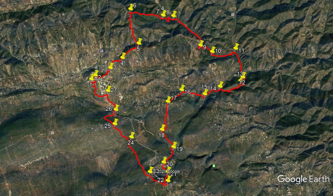
Walk Sixty Six. Salir - Touriz - Mesquita Circular. 21.4k Ascent: 900 metres.
GPS: (37/8) 14. 24. 83 02. 53. 42
Salir is a small market town fifteen minutes north of Loule in the east-central area of the Algarve. it is an excellent jumping off point for a number of walks, either starting from there or in the valley to the north. This walk begins at a cafe which is also the start point for numerous others in this sreies. It is longer and more demanding than any of the others, but it takes in elements of some of them. It begins with a walk through the town and proceeds to climb the hills to the north, then descends again to a valley east of the town. From there it goes cross country to a settlement on the Loule road before ending with an approach from the south. There are one or two stream crossings, so care is needed after heavy rain. There are two places of refreshment close to the route. The route is quite complicated, so good navigational skills are required, although the usual detail is supplied in the description.
Getting to Salir
From the south, take the IC1 road from the A22 motorway or the N125 near Albufeira, and travel north to Messines. Follow signs to Alte and Salir, going east on the N124. Pass through Alte and Benafim on this road and arrive at a roundabout, signed right to Salir. Go up the winding road and find Cafe Opcao on the left soon after reaching level ground. Park on either side of the road - the locals all do!
From further east, you can take the M525 north from Loulé to Salir. Follow the main road round Salir, pass the (unopened) fire station/ GNR post and petrol station and find the bar on the right soon afterward.
The Walk.
Start from the Bar Opcao on the outskirts of the town. (1) With your back to the bar, turn right and walk to the first turning on the left, a sharp turn. Walk up the the T junction and turn right. Shortly turn right again into the main street, opposite the Farmacia (Chemist). Turn right and then first left (2) to walk gently uphill. At the next junction turn right to walk first downhill and then steeply uphill to reach the small square in front of the parish church. (If you can find it, you could start from here, as there is a bar, but you would have to walk up to it at the end.) Turn down the street immediately before the bar on the left, walk part way down and then take a fork on the left. Turn left again at a junction to walk down to a main road. Turn right and then first left by a house (3), and walk along to the north. Take the second turn on the right, a tarmac road, and then the first on the right, to pass in front of a house, after which the road turns into a dirt track. Now take the first turn to the left, (4) which takes you uphill onto a ridge.
After 770m, reach a cross-tracks and turn left uphill.(5). Go downhill for a short distance, and then climb steeply uphill, heading north the whole time. Pass one turn to the right in a small loop in the track, and look for a second right turn heading off southeast, 1.15k from point 5. (6). After just over 1k, bear left at a junction (7), and continue on the track into a narrow valley with a stream (or dry water course) in the bottom.(8) Turn right and follow the stream. Paths run alongside it and sometimes cross over. On the odd occasion you may be walking in the stream or stream bed. This continues for just over 1.5k. After going round a wide right hand bend, come to a crossing point where a track goes off uphill on the left, (9 )roughly northeast. Follow this, and after 100m turn sharp right to follow it as it continues to rise very gently. Turn quite sharply left and then after another short interval right, followed by a southeasterly walk of 330m to reach a junction. Turn right here to reach another junction very shortly (10).
Here turn sharp left and walk for around 660m due west, then turn left and soon right to descend steeply to a wide track in a valley (11). Now turn right and walk for 630m, more or less due south, to arrive at a tarmac road. Cross diagonally left to find the start of a track continuing the southward trend, and follow it. The track passes through wood and scrubland, rising a little, then descending gently, finally turning due west for a short distance to reach a sharp turn left, heading for a wooded hill.(12). Go foward towards the hill and find a track which takes you very steeply up through it to a ridge. At the top turn right and walk for 100-120m to a track on the left taking you steeply downhill (13). Over the next 750m, follow the edge of woodland roughly westward. Two-thirds of the way along descend to a stream and veer more northwest to reach a tarmac road (14).
Dogleg left and right to enter a rough path to the south of a stream. Walk for 150m and cross the stream or stream bed. Pick up the track on the other side, heading northwest, and follow it for 100m. Here you can veer left off the track and cross rough land for another 100m, to find another track heading south. (If the undergrowth is too thick, simply follow the track now for another 100m, then turn sharp left to link up with the southerly track.) Walk alongside the stream for just over 300m and arrive at another crossing point off to the left. (15). Turn right here, away from the stream and follow what is now a very good dirt track roughly northwest. Around 800m further on, after passing to the right of a small settlement, reach a tarmac road (16) and turn left along it. After 280m, fork left uphill on tarmac to walk up to the settlement of Palmeiros.
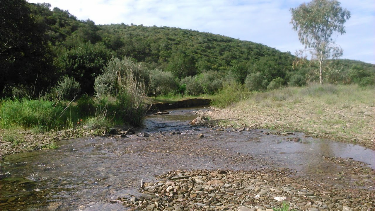
Stream near Point 15. Photo credit: David Hunter
Dogleg right and left at the houses to enter a lane leading due south (17). After 400m go right and then left to continue the southward trend. After another 600m leave the wide dirt track to turn southeast on a much less obvious cart track (18), heading east of south. After 390m, it turns 90 degrees right, then quite soon 90 degrees left, to come after another short distance to a fork, (19) with a ruin below you on the right. Drop down to the ruin, walk past it and come to a wider track. Turn right along it, now heading southwest. Pass a large building up to the right, and then turn left at a junction. Pass buildings on the left, ignore a turn to the left, go through a narrow bit of road, and walk into the middle of a small group of houses. (20).
Turn left facing due south, and at a fork, take the left hand option and continue round quite a sharp right hand bend, coming to a junction after 130m. Turn right off the road onto a dirt track and walk for 100m. At a bend, (21) go straight ahead and find a narrow and not too distinct track winding uphill towrds buildings above. Emerge on a main road between buildings. This is Mesquita, and the road is the main route from Loule to Salir.Turn left and walk 100m to the bend ahead. Turn right uphill off the main road (22). Go right at a fork and follow the road out of the village for 260m to another fork. Go right again and follow for another 350m as the road ends by a house and becomes a track. (23)
Now follow the track as it first heads off across what was a cultivated space, and then runs through the mato (undergrowth), up and over a long hill, general direction just west of north. After just over 1.1k, come down to a narow tarmac road and turn right. Soon arrive at a wider road, (24) turn left and then immediately right into another narrow road, Caminho dos Covoes. Walk up the hill for 670m, and take the first clear turn on the right, just before the village boundary sign for Covoes. (25) This track narrows into a rocky footpath heading downhill to meet a much wider dirt road after 430m. Turn right into this, and follow it down as it passes a refurbished well, turns into a tarmac road, and ends at a junction with a wide main road. (26). Turn left to cross a long bridge (Ponte de Salir) and start to climb. Immediately after the first buildings on the left, find a narrow tarmac strip on the left (27) and follow it. It turns right after 190m, but go straight ahead onto a rough track. It goes right through a bush line after less than a hunded metres. Follow it as it first runs on the top side of the bushes, then turns uphill. From here, just follow the rough tracks uphill towards the buildings up ahead. Emerge onto a wide main road and turn left to walk back to the bar and your car.
GPS Points: 37/7-8
| 1 | Cafe Opcao | 14 | 24 | 83 | 02 | 53 | 42 | |||
| 2 | Farmacia | 14 | 28 | 02 | 02 | 47 | 44 | 370m | ||
| 3 | Turn off main road | 14 | 32 | 44 | 02 | 27 | 01 | 680m | ||
| 4 | Turn to hill | 14 | 40 | 29 | 02 | 09 | 33 | 650m | ||
| 5 | Left at Xtracks | 14 | 51 | 11 | 01 | 45 | 29 | 780m | ||
| 6 | Turn to valley | 15 | 26 | 31 | 01 | 47 | 00 | 1.28k | ||
| 7 | Bear left | 15 | 15 | 02 | 01 | 07 | 66 | 1.12k | ||
| 8 | Turn right | 15 | 13 | 03 | 00 | 54 | 64 | 560m | ||
| 9 | Cross stream | 14 | 37 | 65 | 00 | 27 | 80 | 1.52k | ||
| 10 | Sharp left | 14 | 28 | 73 | 00 | 14 | 88 | 680m | ||
| 11 | Turn right | 14 | 27 | 32 | 59 | 44 | 46 | 830m | ||
| 12 | Turn left to hill | 13 | 57 | 04 | 59 | 42 | 98 | 1.1k | ||
| 13 | Turn off ridge | 13 | 53 | 56 | 59 | 47 | 26 | 310m | ||
| 14 | Dogleg | 13 | 52 | 06 | 00 | 13 | 94 | 830m | ||
| 15 | Right away from stream | 13 | 47 | 49 | 00 | 35 | 03 | 620m | ||
| 16 | Left on tarmac | 13 | 56 | 20 | 01 | 03 | 26 | 840m | ||
| 17 | Left off road | 13 | 47 | 27 | 01 | 23 | 41 | 610m | ||
| 18 | Left to rough track | 13 | 20 | 41 | 01 | 37 | 56 | 1k | ||
| 19 | Right to ruin | 13 | 00 | 94 | 01 | 27 | 71 | 830m | ||
| 20 | Left in village | 12 | 48 | 08 | 01 | 43 | 58 | 650m | ||
| 21 | Foot of narrow path | 12 | 37 | 89 | 01 | 40 | 98 | 370m | ||
| 22 | Right in Mesquita | 12 | 29 | 57 | 01 | 42 | 79 | 360m | ||
| 23 | Bear left | 12 | 41 | 89 | 02 | 02 | 33 | 680m | ||
| 24 | Left at tarmac | 13 | 19 | 14 | 02 | 17 | 42 | 1.31k | ||
| 25 | Right off road | 13 | 35 | 44 | 02 | 34 | 49 | 710m | ||
| 26 | Left, Ponte de Salir | 13 | 49 | 42 | 02 | 30 | 42 | 810m | ||
| 27 | Left off road | 14 | 09 | 78 | 02 | 35 | 65 | 730m | ||
| End | 970m |