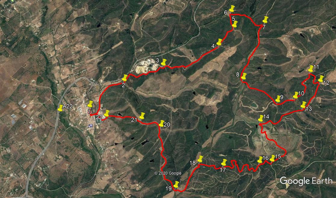
Walk Forty Nine. North of Bensafrim. 18.3k. Ascent: 660 metres
GPS: 37/ 09 19 00 8/ 44 15 53
This is the second walk in the series that starts from the small, attractive town of Bensafrim, just off the end of the A22 motorway in the west of the Algarve. It explores the hills and valleys immediately to the north of the town Moderately challenging, but all on good wide tracks. Refreshments at start and finish, but not at the same place - see the text for details.
Getting to Bensafrim.
The only obvious way from the east is via the motorway. Pick it up at a convenient point and drive to the end. At the roundabout turn right into Bensafrim and drive down to the open square on the left, beyond which is the market building and a café. Park here to begin the walk. Coming from Lagos, take the N120 from the eastern end of the town, near the marina, signed to Aljezur. Follow this main road up into Bensafrim at the junction, and find the market square on the right.
The Walk
With your back to the market cafe, (1) turn left and walk round the market building to the back. Continue along the street in front of you, and at the T junction, turn left. At the next junction, follow the road round to the left and walk out of the town. At a junction after 970m, keep left with the main track.Take the second track on the right after 220m,heading roughly north. (2) It climbs quite quickly, then levels off and undulates along, with quarry workings on the left and some woodland on the right. After 750m, come to a junction with a wider track (3) and bear left along it. You are now on a ridge. Follow this for 1.3k. At a fork (4), take the left hand track uphill, to reach a summit after another 520m.(5).
Now turn left and descend quite quickly. Take the right hand at a fork, and arrive at a cross-tracks after 320m. (6). Turn right here and continue to descend, more gently, over the next 800m, heading north, then northeast, then north again. Arrive at another junction (7) and turn right. Now walking along a valley,southeastwards reach another junction after 1.3k.(8). Go past the wide track heading southeast, and take the next on the left, a narrow track heading off northeast, quite steeply uphill. After 800m, pass a track heading off southeast, and 100m further on arrive at a junction with another, narrower track going almost due east. (9) Stay right here and walk due north on more or less level ground for 380m. Come to a fork (10), and take the left hand track. This is quite a narrow affair, running between trees. It eventually turns southwestwards and passes round the end of a small barragem, or dam. It then runs northwest and briefly west to reach a junction, 780m from point 10.(11).
Swing sharply right here to stay on the same track, and descend again in a winding fashion, passing some ruins on the left on the way down to the valley floor. At the junction here (12), turn right, and walk along the valley. Where tracks cross your line after 670m (13), stay on the main valley road. Walk south for another 1k. Arrive at a junction with a barragem ahead and left. Turn left through this hairpin bend (14), and follow the wide clear track as it climbs fairly gently. Hairpin right after 280m, climb to level ground after a further 660m, and then walk along east of south for another 380 to find a junction at a point where the track begins to curve to the left. (15). Turn right here on a narrower track, heading south again. At a complex junction after 320m, (16) take the track straight across, heading southeast. Over the next 1.35k, the track winds around a good deal, but your trend is always due south. To help you, use the following instructions for each of the several junctions on the way. 210m, left; 80m,right; 140m, right; 100m, left; 160m, right; 160m, left (this is a short cut to avoid a loop in the track.) Then turn left to complete the section after another 260m.
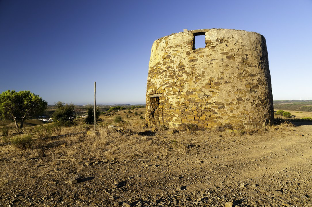
Old windmaill above Bensafrim
Arrive at another multi junction (17), and head straight across, going due south. At a junction after 210m, turn left and continue south, descending quite quickly, to a junction in the valley. (18) Turn left. Walk along the valley for 680m, passing buildings left and right towards the end, and then take the first turn on the right, which leads you across the valley floor to a stream crossing. Once across, dog-leg left and right (19), to start climbing, rising onto a ridge. Stay on the upward trend, ignoring all turns left and right.After 940m, stay right at a fork, and continue more or less due west, with two largeish barragems in the valley below on the left. Arrive at a summit, with an old windmill base (20), and swing round to the south, starting to descend quite quickly. Fork right twice and arrive at a third fork after 500m.(21) Take the left here (you can see Bensafrim below), and follow the track down, to hit a tarmac road on the outskirts of the town. (22). Go left and right to walk past the football club and along to a junction. Turn left here up the hil and then right to return to the market square. The market cafe will be closed on your return, but there is another cafe if you go onto the main road and turn right.
GPS Points. (37/8) Orientation: North is on the right.
| 1 | Bensafrim market | 09 | 19 | 00 | 44 | 15 | 53 | |||
| 2 | Stay left | 09 | 46 | 88 | 44 | 30 | 60 | 1.26k | ||
| 3 | Bear right | 10 | 14 | 36 | 44 | 37 | 81 | 1k | ||
| 4 | Fork left | 10 | 53 | 38 | 44 | 46 | 24 | 1.34k | ||
| 5 | Fork left | 11 | 05 | 80 | 44 | 58 | 83 | 520m | ||
| 6 | Turn right | 11 | 05 | 65 | 45 | 12 | 18 | 330m | ||
| 7 | Hairpin right | 11 | 26 | 17 | 44 | 57 | 92 | 790m | ||
| 8 | Ahead, then left | 11 | 05 | 87 | 44 | 14 | 20 | 1.33k | ||
| 9 | Turn left | 11 | 24 | 03 | 43 | 50 | 68 | 880m | ||
| 10 | Turn lerft | 11 | 37 | 34 | 43 | 51 | 08 | 400m | ||
| 11 | Hairpin right | 11 | 49 | 96 | 44 | 10 | 65 | 780m | ||
| 12 | Turn right | 11 | 55 | 93 | 44 | 00 | 88 | 400m | ||
| 13 | Stay right | 11 | 41 | 10 | 43 | 41 | 96 | 680m | ||
| 14 | Hairpin left | 11 | 11 | 86 | 43 | 36 | 87 | 1k | ||
| 15 | Turn right | 11 | 14 | 49 | 43 | 02 | 45 | 1.35k | ||
| 16 | Multi junction | 11 | 06 | 16 | 43 | 03 | 13 | 340m | ||
| 17 | Multi junction | 10 | 42 | 11 | 43 | 06 | 20 | 1.13k | ||
| 18 | Turn left | 10 | 27 | 05 | 43 | 12 | 21 | 560m | ||
| 19 | Dogleg | 10 | 08 | 22 | 42 | 54 | 51 | 870m | ||
| 20 | Bear left | 10 | 05 | 78 | 43 | 47 | 42 | 1.49k | ||
| 21 | Fork left | 09 | 53 | 74 | 43 | 56 | 50 | 490m | ||
| 22 | left and right | 09 | 30 | 63 | 44 | 03 | 86 | 810m | ||
| End | 470m |