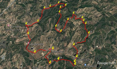
Walk Forty Two. Marreiros Circular. 16.5 kilometres. Ascent: 600 metres.
GPS: 37/ 16.33.59 8/ 13.42.08
This walk, just east of the town of Sao Bartolomeu de Messines, is a true hill walk, with a bit of lowland to finish. Starting from the small settlement of Marreiros, it heads off straight into the hills to the north, and takes in two highpoints between sections of valley and ridge. The views are worth the effort. The later stages see a descent to valley level and a finish in more cultivated terrain. The restaurant at Marreiros, which is the start point, will serve just drinks if you wish. Closed on Wednesdays. There are no other refreshments on the route.
Getting to Marreiros.
From the A22 motorway, take the A2 motorway north to Messines. At the end of the approach road to the motorway, turn right towards Messines. At the end of the long straight, turn sharp right and follow this road as it heads west away from Messines, under the motorway, and from there drive a further 3.5k to find the Restaurante Marreiros on a sharp right hand bend. Try to park away from the restaurant car park to save the space for lunchtime guests.Best place is alongside the derelict buildings at the very start of the walk, just beyond the restaurant. From east or west, you can follow the N124 from Benafim or Silves, turning right or left at the motorway roundabout, depending on your direction of approach. There is a more complicated but shorter approach via Alte and Santa Margarida, if you want to use Google to work it out!
The Walk
With your back to the restaurant, (1) turn right and almost immediately leave the road by a dirt road on the right. Follow this round to the left, (walk between the two derelict buildings) and walk due east for 260m, taking the right at a fork. After a further 630m, arrive at a tarmac road (2). Dogleg right and left to leave the tarmac and follow a wide dirt road as it turns northwest past a barragem (dam) on the right, and then northeast, passing an estate on the left, then finally running north to reach a junction with a track on the left, 1.32k from point 2 (3). Now continue north for another 680m, passing a couple of barragems and two sets of buildings, all on the left. Drop down a little at the end, and see a track going off to the right at a hairpin bend.(4)Take this track as it first goes south east, then slowly turns to run east northeast over the next 720m, reaching a junction with a track on the right.(5)
Stay on the track as it turns northeast, heading up a valley. After running straight for some time, it turns a little more to the north, climbing gently all the while, reaching a fork after 960m (6). Take the right hand track, and follow just north of east for 370m to point (7), where twin tracks go off left uphill. Ignore these, and several others heading in the same direction, and follow your line, climbing quite steeply now for 550m to another fork (8). Take the right and continue to climb for 270m, to reach a summit, with a trig pillar and a large pylon . From here, the track goes east, then southeast and finally due south, descending more steeply towards the end, to reach a crosstracks after 320m. (9) . Turn right here and walk steadily downhill for 360m. At a junction (10), the track turns due south. After 330m, come to another cross-tracks and turn left. (11).
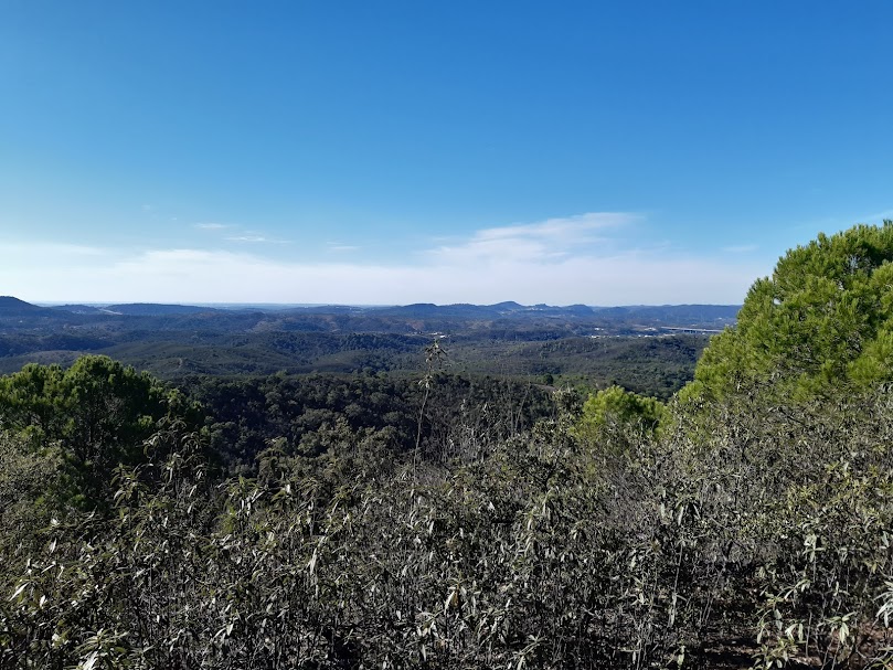
Amazing view from Trig Point Coentral
Walk down a long ridge for 1k, taking the left at a fork as you reach the end (12), and descend quickly to a junction at the bottom. Now turn left and walk along the valley for 300m, passing a barragem on the right, to reach another junction. (13). Turn left and almost immediately fork right to head northeast in a valley for 830m. When the path starts to appear a little indistinct, look for a way across the ditch on the left, and cross, turning right afterwards. Walk parallel with the ditch and a track opens up. Pass an old well and drop down into a hollow. Ignore two tracks on the left, and go straight ahead, climbing steeply . At a junction 190m from the hollow, swing round right to face southeast for 100m, before turning sharply northeast again. From here climb steadily and then descend as the track goes northeast, then east, then almost due north, over 380m, to arrive at a junction by a derelict cottage (15).
Take the first on the right after the cottage and walk down to a wide dirt road. Turn right and walk along for 200m, turning left on a track with a small plantation on the right, heading north of east. Follow this for 370m. It turns southeasterly again, then curves round back towards northeast. Just beyond this curve, find a rough track going off to the right (16). Swing round to face due south, and follow this rather indistinct track south for 200m, rising at the end, to arrive at a junction. Turn right and then curve round to the left (17), to go south for 100m. At a cross tracks turn left and follow for another 100m.Finally bear right for another 100m, almost due south, to a junction with a wider track. (18). Now head due south for 630m, descending all the time. Half way along, the track kinks to the left, but then resumes the southward trend.
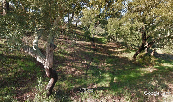
Cork oak plantation nesr the end of the walk.
At a fork (19), take the right hand track, and follow it for 1.16k as it continues to descend steadily, passing a barragem on the left. The direction now is more southwest, swinging more west towards the end.Arrive at a fork (20) and take the left hand track, climbing over a ridge and then descending south over the next 630m, passing between two barragems to come to a tarmac road. (21). Turning right here will take you straight back to the start, a distance of around 1.3k.
If you are up for another climb, and off-road, cross over the road and walk along a hard surfaced lane until it turns a corner towards some ruins. Go straight on, through the line of trees ahead on a track, and follow the same line along the next field, keeping close to the tree line. Coming to a track under the hill ahead, (22) turn left, following a track that soon makes a right-hand curve, and after 140m, come to a fork in the track. (23). bear right here and climb first northwest and then more or less due west over 860m, Arrive at point 24, which is at the bottom of a steep slope leading up tothe remains of an old windmill. Pass this just below the hill opn the right, through a rather overgrown path, and descend to the right of a three-string fence. Where the slope flattens out a little, turn left and follow a track down a steep slop, and along the hillside for just under 300m. Drop into a gulley (25) and turn right to descend on a narrow, again rather overgrown path, passing a stone shack on the way down. After another 300m, pass to the left of a small barragem and soon emerge onto a tarmac road. Turn right to walk for almost 500m back to the start.
GPS Points: 37/8
| 1 | Restaurant Marreiros | 16 | 33 | 59 | 13 | 42 | 08 | |||
| 2 | Tarmac road | 16 | 28 | 14 | 14 | 08 | 14 | 900m | ||
| 3 | Track on left | 16 | 59 | 29 | 14 | 33 | 67 | 1.32k | ||
| 4 | Hairpin bend | 17 | 18 | 07 | 14 | 41 | 26 | 680m | ||
| 5 | Track on right | 17 | 23 | 50 | 14 | 16 | 17 | 720m | ||
| 6 | Fork right | 17 | 52 | 24 | 14 | 04 | 30 | 960m | ||
| 7 | Tracks keft | 17 | 55 | 90 | 13 | 51 | 00 | 370m | ||
| 8 | Fork right | 18 | 02 | 85 | 13 | 30 | 93 | 550m | ||
| 9 | Cross tracks | 17 | 56 | 28 | 13 | 14 | 29 | 500m | ||
| 10 | Cross tracks | 17 | 51 | 75 | 13 | 26 | 86 | 360m | ||
| 11 | Turn left | 17 | 41 | 42 | 13 | 29 | 05 | 330m | ||
| 12 | Fork left | 17 | 12 | 79 | 13 | 36 | 49 | 1k | ||
| 13 | Turn left | 17 | 03 | 37 | 13 | 26 | 19 | 420 | ||
| 14 | Fork right | 17 | 26 | 20 | 13 | 10 | 31 | 830m | ||
| 15 | Round to SE | 17 | 38 | 91 | 12 | 57 | 11 | 670m | ||
| 16 | Round to due South | 17 | 29 | 46 | 12 | 38 | 46 | 780m | ||
| 17 | Turn south | 17 | 23 | 39 | 12 | 36 | 54 | 220m | ||
| 18 | Head south | 17 | 17 | 19 | 12 | 32 | 85 | 300m | ||
| 19 | Fork R | 16 | 59 | 49 | 12 | 28 | 85 | 630m | ||
| 20 | Fork left | 16 | 39 | 70 | 13 | 01 | 13 | 1.16k | ||
| 21 | Tarmac road | 16 | 21 | 11 | 12 | 57 | 15 | 630m | ||
| 22 | In trees | 16 | 14 | 13 | 13 | 01 | 66 | 240m | ||
| 23 | Fork right | 16 | 10 | 43 | 13 | 01 | 17 | 140m | ||
| 24 | Straight on uphill | 16 | 17 | 07 | 13 | 31 | 07 | 860m | ||
| 25 | Turn right | 16 | 12 | 50 | 13 | 46 | 41 | 500m | ||
| END | 900m |