Walk Seventy One. Sarnadas - Brasiera Circular. 22.8kilometres Ascent: 1028m
GPS: 37/ 16. 05. 86 8/ 09. 10. 79
This is amongst the most challenging walks in this series, but it offers big rewards. It is definitely a walk of two halves, with a strenuous outward leg and a much more gentle return. Starting from the small village of Sarnadas, north of Alte, it wanders to the west for a while before climbing to a ridge which overlooks two very different valleys. The route then follows the ridge eastwards through many quite significant ups and downs, to reach the furthest point east near the hamlet of Brasiera de Cima, perched on an odd little hill. From there the walk returns to Sarnadas on a track just above the valley floor. There is a shorter version which avoids the early westward wander. There is a small bar at Sarnadas for coffee etc, but no other refreshments en route. The saving grace of this walk for anyone nervous about distance and ascent, is that there are any number of escape routes on the difficult first half.
Getting to Sarnadas.
From the A22, the best approach is from the Boliqueime exit. Follow the signs for Loule and take the second turn on the left, after the large quarry. At the T junction turn left through Parragil, and follow this road down into a valley at Ribeira de Algibre, then up to a high point at Alto Fica. Continue on the same road, down and up once more, to the village of Benafim. Here go straight across at the roundabout and follow this road into open country, dropping down eventually into a wide valley with a large pond and building in the middle. As you cross the valley floor, come to a junction signed for Sarnadas, and drive the 2k or so into the village. Parking is not abundant, so pull off where you can when the houses begin.
If you come from the west along the N124, turn off at Alte. Just after a statue on the left, hairpin right up the hill and follow the road to Santa Margarida. In the middle of the village, turn right, by a bank of road signs (doesn´t include Sarnadas), and follow the road to the village.
The Walk.
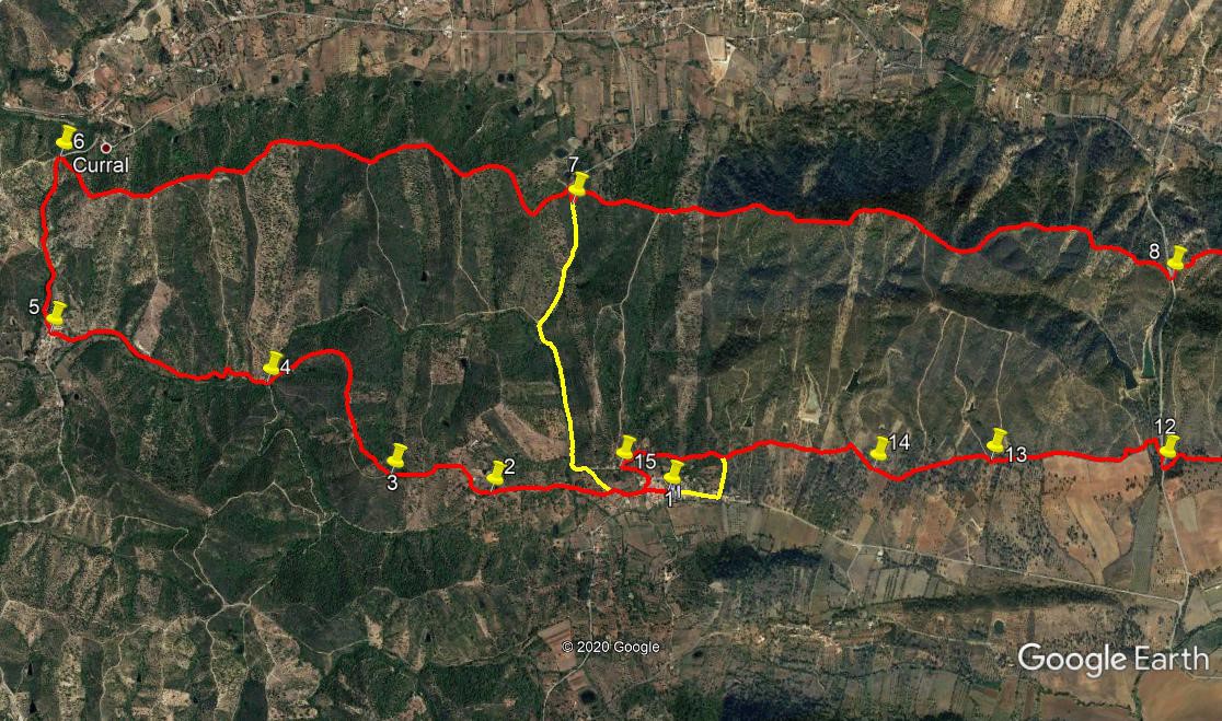
With your back to the bar, (1) turn right and walk out of the village. At a fork after200m, bear right, (2) and bear left to leave the tarmac after a short distance. Follow this clear track westwards. Pass a farm on the left, then turn more northerly, climbing all the time. Pass in front of another farm, and immediately after this the clear track ends. (760m from point 2. Take the left fork on what is now a dirt track and follow for 330m to a fork (3). Take the less obvious right hand here, and follow it as it heads roughly north west. After 250m, it rejoins the original track, and heads due north before describing a wide semicircle to face south west, now descending. 1.1k from point 3, arrive at a track junction (4).
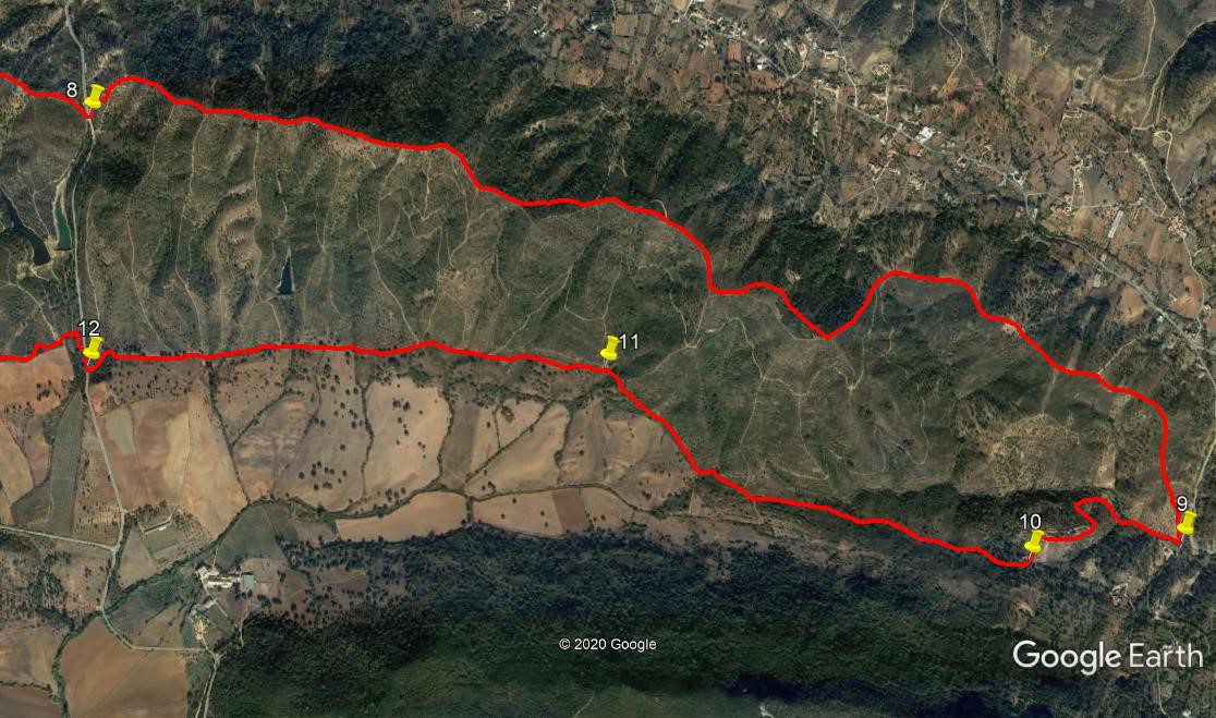
Take the track straight across, heading west. Walking in a valley now, continue for 1.14k, climbing a little at the end to reach the hamlet of Joao Andrea at a tarmac road.(5).Turn right and walk up the road for 840m. Reach the top of the hill to find a track crossing your line, (6) and turn right uphill. You are now on a ridge line, which you will follow to the far eastern end of the route. The ridge is far from level ground, so be prepared for many ups and downs. Stick strictly to the ridge, crossing a tarmac road after 2.73k (7). Turn down the road for a few metres to pick up the ridge track once more. After another 3k, cross another road (8), this time walking straight across. From there, the ridge continues for another 4.7k, finally dropping down to yet another tarmac road.(9). Turn sharp right here along the tarmac, on level ground at first, then rising quite quickly, passing through two wide bends and finally arriving at the hamlet of Braseira de Cima.
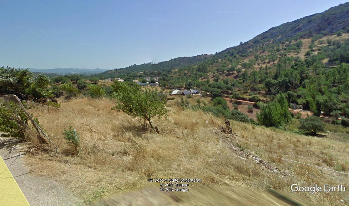
Looking east from near Braseira
Take the left fork before the settlement and walk through it to the end of the tarmac. Turn left at the end of the buildings and descend a little to an open space with bits of ruin on the right. (10) Find a track on the right after the ruins, and turn into it. You are now on the return leg of the walk. Follow this clear track for 1.69k, firstly heading more or less due west, then turning to north west to reach a junction near a small barragem (dam) (11). Here take the left hand of two tracks heading west. Maintain this line for another 1.8k to arrive at a tarmac road (12). Turn right up the road, and take the first track on the left, a narrow path heading north northwest. After 100m, swing left to resume the westerly trend, and follow for another 950m to a junction, with a barragem down to the left. (13).
Stay left through this junction and continue along the new rather wider track for another 580m to arrive at a 90 degree turn to the left at the corner of a plantation.(14) Bear off to the right here, following a rough track through trees, to reach a more obvious track after 150m. Turn left here, and after a shorrt distance bear right on a rather indistinct track line, heading more or less west. Take the right fork after 140m and follow the general westward line across several junctions with tracks running north - south. NOTE. At any time from here, you can turn south on any of these crossings to reach the tarmac, where turning right will take you into Sarnadas. To continue, simply follow the line as it heads more south west for a time and then west again, passing to the north of Sarnadas village. After roughly 1k, pass a house on the left, and turn left to walk a short distance down to a tarmac road (15). Here turn left again to walk towards the village. After 140m, turn right down a narrow alleyway to wind between the houses, coming out on the road through the village where you began. Turn left to reach the bar.
Shortened Version.
At the second fork outside the village, take the main road (tarmac), and follow it up to the ridge, to join the main route at Point 6.(Yellow line on the photo). Turn right to follow the ridge line. The other yellow line illustrates one alternative finish to the walk.
GPS Points. 37/8
| 1 | Sarnadas | 16 | 05 | 86 | 09 | 10 | 79 | |||
| 2 | Fork R | 16 | 07 | 08 | 09 | 43 | 12 | 750m | ||
| 3 | Fork R | 16 | 10 | 62 | 10 | 01 | 17 | 540m | ||
| 4 | Fork R | 16 | 25 | 11 | 10 | 23 | 79 | 1.1k | ||
| 5 | R at tarmac | 16 | 34 | 31 | 11 | 03 | 15 | 1.14k | ||
| 6 | R off tarmac | 16 | 59 | 72 | 10 | 58 | 33 | 840m | ||
| 7 | Road 1 | 16 | 48 | 60 | 09 | 24 | 19 | 2.73k | ||
| 8 | Road 2 | 16 | 32 | 83 | 07 | 36 | 83 | 3k | ||
| 9 | At tarmac | 15 | 39 | 44 | 05 | 09 | 67 | 4.7k | ||
| \0 | R after Braseira | 15 | 38 | 32 | 05 | 32 | 03 | 800m | ||
| 11 | L at junction | 16 | 02 | 07 | 06 | 28 | 63 | 1.69k | ||
| 12 | R on tarmac | 16 | 05 | 60 | 07 | 39 | 93 | 1.81k | ||
| 13 | Stay L at junction | 16 | 07 | 78 | 08 | 11 | 60 | 950m | ||
| 14 | Field corner | 16 | 07 | 78 | 08 | 33 | 02 | 580m | ||
| 15 | At tarmac | 16 | 09 | 84 | 09 | 19 | 28 | 1.27k | ||
| End | 300m |
NOTE: I have divided the photo into two for this walk, as it is so stretched out.