Walk Fifty Seven. Quinta da Odelouca Circular. 16k with optional 1.8k extension. Ascent: 700m
GPS; 37/ 20.32.52 8/ 22.14.82
This walk covers an area to the left of the IC1 road, just south of Sao Marco da Serra. Starting from the edge of a camping site, it winds over modest hills and through pleasant valleys, taking in some quite isolated farmsteads and hamlets. Refreshments can be had at the Sao Marcos exit from the IC1, either before the walk, or after, or both! There are no others on the route.
Getting to Quinta da Odelouca. ( A camping site)
From all directions in the Algarve, drive to the IC1 either at the Albufeira/Guia exit from the A22, or on the N124 at Messines. From Messines,go north for around 13k to the exit for Sao Marcos da Serra, and turn off. You can get coffee here if you wish. Then go over the main road on the bridge and rejoin the IC1 going south. Take the first turn on the right, which is a narrow lane with large waste bins on the right hand side. NOTE: You need to go to the junction to turn round because the road is marked with a solid white line. Portuguese police are very keen on this, and if caught crossing it the consequences can be severe. Go along the lane for almost 500m, cross the railway and run parallel for a short distance before turning away and driving a further 900m to a junction, with farm buildings off to the right. Stop here and park where you can.
The Walk
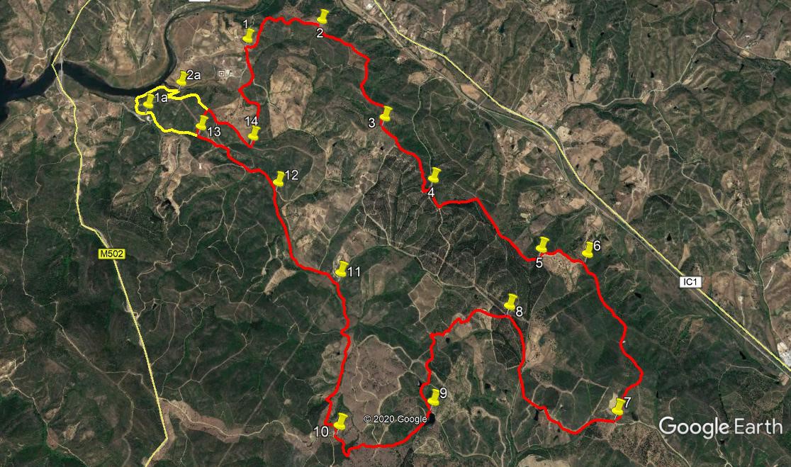
Start off on the track opposite to the one leading to the farm, (1) heading east and quickly turning north northwest, climbing quite steeply, and running more or less parallel to the track you drove in on. At just under 400m, the track turns to run south of east, still climbing. Stay right at a junction after 320m, reach a high point soon after, make a sudden turn south and reach another fork after 250m (2). Keep left here and walk south west for 560m,on more or less level ground, with rising land to your right, and descending to your left. Now turn south for a further 770m, starting to rise over the second part, then descending a little to reach another fork (3). Stay left here
Now follow a descending line, more or less south west, over the next 780m, turning sharp left near the end at a complex junction, to meet another track (4). Turn sharp right at this point, and walk for 190m, gently uphill, and take the first left at another complex junction, to continue rising steadily over another 340m to reach a cross-tracks. Turn right and continue for 740m, rising to a summit and starting to descend. Turn left at the end of this section to face east, and very soon, when the track turns south again, turn left off it onto a less obvious track heading northwest uphill. (5). Follow this for 200m to arrive at a T junction. Turn right and descend slightly before reaching level ground and coming to a cross-tracks after 23m. (6).
Go straight across and follow this generally south - tending track over the next 1.5k, rising at first, then following an undulating course before finally descending quite sharply. The track turns more south westerly on the descent, to reach a wider track in the valley. (7) Turn right. You will now follow this track called Rua de Seiceira, for quite a distance. Stay left at a fork after 1k. At a complex junction after another 500m turn second left (8) and shortly pass a farm on the right. Walking now generally west or south west, continue for another 540m, passing another farm on the left. Soon after the farm turn sharp left to face south, and after 110m take the left fork. 220m on fork to the right, and after another 100m go straight on at a cross-tracks, to walk to the left of a small barragem (dam). 260m from the cross-tracks come to a fork in front of a larger barragem (9).
Take the right hand track and follow as it makes a wide curve to the right. Go straight on at a junction after 500m, and continue as the track dips south through a wooded area, to turn north again and reach a T junction after another 500m. (10). Turn right here and walk for 1.3k northwards, as the track descends, quite sharply at first and then more gently to arrive at a fork, with farm buildings and a barragem ahead and right.(11) Take the left here and after 190m, where the track turns north, go left along a cart track on the edge of a large field. Stay on the track as it cuts through the trees on the left after 400m, and stick to the tree line along the edge of the next field for 100m, to find another track leading out of the field, still going north. After another 400m, emerge onto a much wider track.(12) Turn left and stay on this track for 1.1k. Stay right at a fork after 520m, and again after another 320m, ignoring three minor tracks on the right hand side. 210m on from the second fork, find a track on the right climbing steeply uphill (13).* The extension starts here, see below. After 250m, come to a T junction at the top and turn right. * The extension ends here.The track goes over level ground for a short distance and then descends quite quickly. At the bottom of the hill (14) turn sharp left to walk along a valley, heading due north. After 410m, join a track coming in from the right and continue round a left hand and then a right hand bend. 230m from the track junction turn through 90 degrees to the right and follow the track, to arrive at a much broader track after another 190m. Turn left and walk along, rising gently, for 290m, to return to the start of the walk.
Extension.
At Point 13, instead of turning right, go straight on for 580m, to a bend with a building inside it, where the road surface changes. (1a) Turn right off the road here, on a rough track that bends to the right and leads down to a creek. Follow round to where the creek joins a river, and walk along the bank for 240m, to where another creek comes in. Turn right with the creek and walk for 170m, to find a track going right at a hairpin bend. (2a) Walk up this track, turning sharp left and left again after 100m. Now follow this track as it leads uphill for 460m. At the summit, the extension ends.
GPS Points (37/8)
| 1 |
Near Quinta da O. |
20 |
32 |
52 |
|
22 |
14 |
82 |
|
|
| 2 |
Fork L |
20 |
34 |
44 |
|
21 |
48 |
02 |
|
940m |
| 3 |
Stay L |
20 |
02 |
50 |
|
21 |
27 |
13 |
|
1.34k |
| 4 |
Sharp R |
19 |
44 |
48 |
|
21 |
11 |
46 |
|
820m |
| 5 |
L off main track |
19 |
23 |
06 |
|
20 |
37 |
36 |
|
1.29k |
| 6 |
Striaght at X tracks |
19 |
21 |
02 |
|
20 |
22 |
85 |
|
450m |
| 7 |
R at junction |
18 |
40 |
47 |
|
20 |
18 |
35 |
|
1.52k |
| 8 |
2nd L at complex |
19 |
08 |
47 |
|
20 |
49 |
56 |
|
1.53k |
| 9 |
R fork |
18 |
45 |
32 |
|
21 |
16 |
43 |
|
1.43k |
| 10 |
R by farm |
18 |
40 |
76 |
|
21 |
46 |
55 |
|
1k |
| 11 |
L fork |
19 |
19 |
78 |
|
21 |
44 |
91 |
|
1.4k |
| 12 |
Join track from R |
19 |
46 |
15 |
|
22 |
05 |
19 |
|
1.1k |
| 13 |
Turn off uphill |
20 |
03 |
86 |
|
22 |
32 |
63 |
|
940m |
| 14 |
L turn |
19 |
59 |
80 |
|
22 |
13 |
84 |
|
800m |
| End |
|
|
|
|
|
|
|
|
|
1.12k |
| 13 - 1a |
Turn R for creek |
20 |
11 |
70 |
|
22 |
51 |
47 |
|
580m |
| 2a |
Hairpin R |
20 |
18 |
23 |
|
22 |
39 |
95 |
|
650m |
| Main route |
Summit |
20 |
10 |
88 |
|
22 |
28 |
61 |
|
580m |