Walk Two. Aguas Frias - Sao Barnabe Circular 20.7k. Ascent: 866 metres.
This is a lengthy but straightforward walk, almost all on wide dirt roads, in the north of the Algarve, crossing over into the Alentejo to make the midpoint at the village of Sao Barnabe. Passing through wild and almost empty countryside, the walk starts from the bar at the hamlet of Aguas Frias, taking in also the barless small settlement of Zambujal. There is a restaurant outside Sao Barnabe where you can have a meal or just a lunchtime drink near a very pleasant river. I am indebted to Ros Smith for planning and leading this walk with the AWW.
GPS 37 18 49 84 8 10.22 79
Getting to Aguas Frias
From the West.
Use the N124 or the A22 and IC1 to travel to Messines. Follow the 124 to the roundabout leading to the A2 motorway, and take the third road off, signed to Messines. At the end of the long straight, turn right, signed on the right to Fonte Joao Luis. Follow this road under the motorway and drive for 8k to Azinhal. Take the second turning to Aguas Frias and follow this road all the way to the hamlet. The Café Aguas Frias is in front of you on the left.
From the East and South.
Leave the A22 at junction Loule Centro and then follow signs to Sao Bras. Turn off this road - the Loule northern bypass - at the Rotunda de Salir, taking the third road off, towards Salir. Follow this all the way to Salir, passing through the traffic lights at Tor on the way. Stay on the same road past the town, and descend to a roundabout on the N124 with a large concrete statue of a lizard. Turn left here are drive for just over 1k, then turn right\, signed to Malhao, Cortinhola etc. Follow this road over the crest between two valleys and then along the next valley through a couple of settlements. At Cortinhola, turn left at the T junction and drive on to Azinhal. There turn left, signed to Aguas Frias. Follow the road through to the hamlet, finding the Bar facing you on the left.
The Walk.
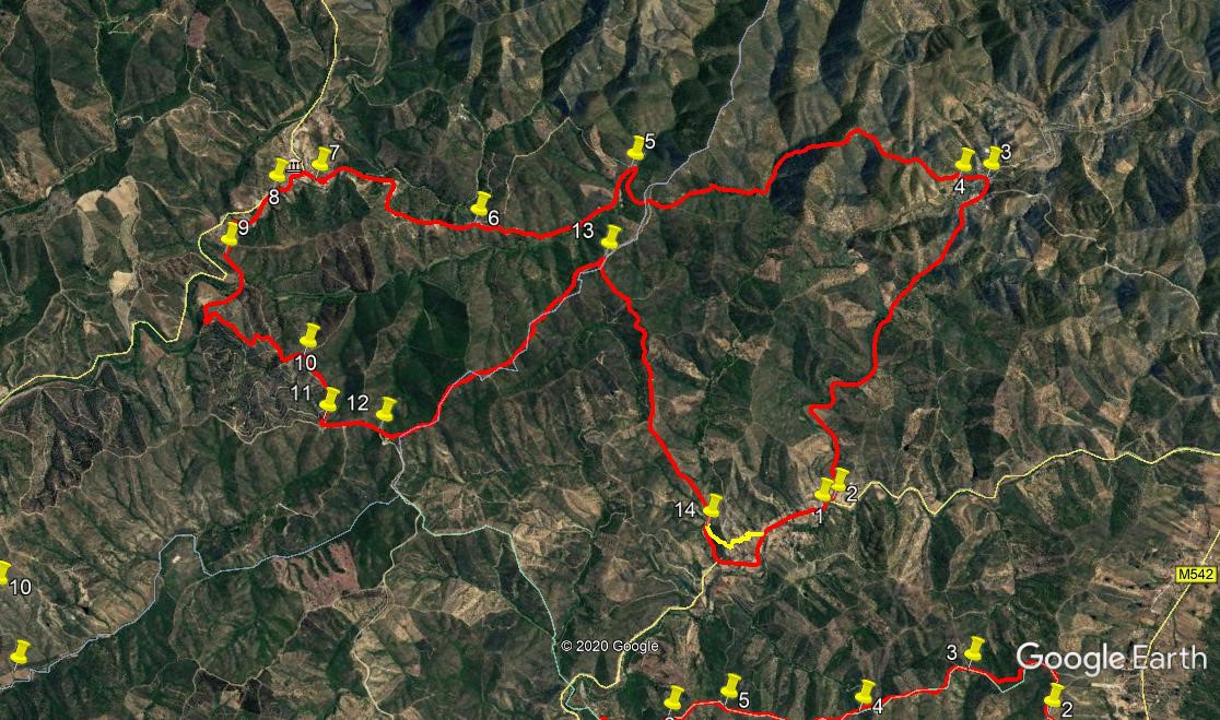
With your back to the café, (1) turn right along the road. Cross a bridge and turn left immediately afterwards, walking uphill on a dirt road. (2). Follow this wide road for 3.5k, ending with a descent to the hamlet of Zambujal. Go down to the bridge and cross it (3).Turn left here, and at a junction after 220m, (4) take the right hand wide dirt road steeply uphill. Climb steadily for just over 1k, to find a long building on the right. Go past this and soon start to descend through trees. Emerge onto open ground after around 700m, and cross an undulating section for the next 1k. Come to a cross-tracks with trees on the left, and carry straight on. Descend through a wooded area again for 430m and at a junction turn sharp left. (5)
Climb a little and walk for a further 1.49k to find a track coming in from the right. (6) After another 1.25k, pass another track coming in from the same direction. After another 340m, during which the track becomes a tarmac surface, find a tarmac lane leading down on the left. At the end of this find a picnic area near a river, with a restaurant over the bridge. (7)You may rest and refresh here if you wish. (If you don’t want to stop here, stay on the main road). After your R and R, walk back up to the road and turn left to walk into Sao Barnabe. At the fork, bear left and walk for 320m, out of the village. At the village boundary sign turn off left (8) onto a dirt track, and follow it for 440m to reach a stream crossing (which could well be dry). Almost immediately swing round in a semi-circle on the track, passing a low building on the right.
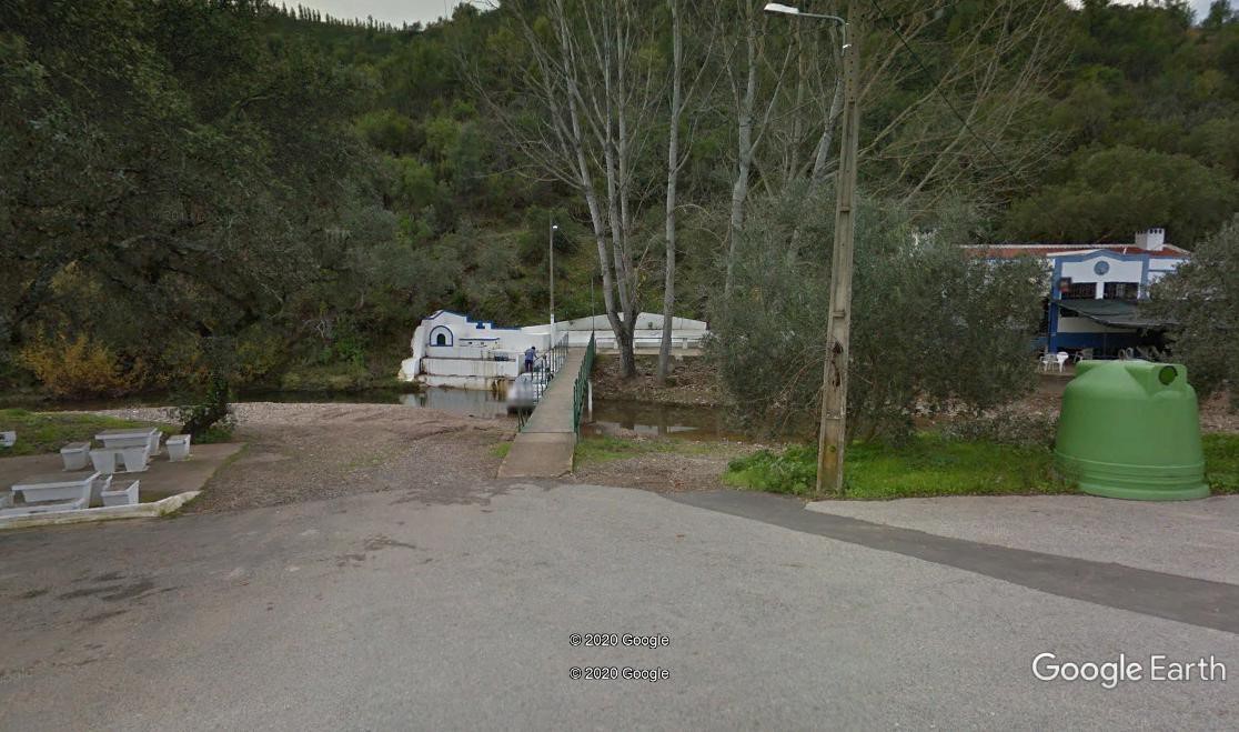
Lunch stop, nr Sao Barnabe.
Now walk round a shallow curve to the right for 160m, to arrive at (9), where the track turns sharp left and heads south southwest, then turns through a wide bend to head back north west, passing a group of farm buildings on the right after 400m. Now follow this same wide track as it climbs steadily, heading generally south after a winding start, for the next 740m, to reach a summit. (10). Take the right fork here and, walking on a ridge line, head first downhill and then up again to reach another fork after 350m. (11) Take the left this time and walk due south for 300m, taking the left fork at (12). Now the track heads broadly south east, climbing at first, then descending steadily, over the next 2.4k, always with land falling away on either side. At the end of this section (13), find a track on the right at a hairpin bend. Turn here, heading first westerly, then turning to south west and continuing to descend steadily over the next 1.69k. Bending a little more to the left here, the descent continues for a further 980m to the valley at (14). Take the right fork here, and come to a wide tarmac road after 340m Turn left along the road, to reach the café and your car after a final 1k.
NOTE: From point 14, taking the left fork will take you uphill and along a winding track/road through the hamlet of Aguas Frias de Baixo. This will bring you out along the main road further on, so if you have an aversion to tarmac, you might like this alternative. (Shown in yellow on the photo).
GPS Points
| 1 | Aguas Frias | 18 | 49 | 84 | 10 | 22 | 79 | |||
| 2 | Turn L off road | 18 | 47 | 54 | 10 | 17 | 72 | 130m | ||
| 3 | Zambujal | 18 | 46 | 72 | 08 | 23 | 09 | 3.5k | ||
| 4 | Turn uphill | 18 | 53 | 06 | 08 | 27 | 42 | 220m | ||
| 5 | Hairpin | 20 | 07 | 70 | 09 | 07 | 75 | 3.1k | ||
| 6 | Track junction | 20 | 39 | 50 | 09 | 50 | 79 | 2.6k | ||
| 7 | Lunch? | 21 | 19 | 05 | 09 | 55 | 63 | 1.6k | ||
| 8 | Turn L off road | 21 | 30 | 53 | 10 | 03 | 40 | 450m | ||
| 9 | Left hand bend | 21 | 32 | 41 | 10 | 27 | 27 | 600m | ||
| 10 | Fork right | 21 | 04 | 52 | 10 | 46 | 58 | 1.15k | ||
| 11 | Fork Left | 20 | 52 | 86 | 10 | 54 | 51 | 350m | ||
| 12 | Fork left | 20 | 39 | 41 | 10 | 57 | 51 | 300m | ||
| 13 | Hairpin | 20 | 06 | 58 | 09 | 38 | 56 | 2.4k | ||
| 14 | Fork Right | 19 | 14 | 20 | 10 | 42 | 35 | 2.5k | ||
| End | 1.34k |