Walk Fifty Four. Pinheiro e Garrado Circular. 21.7k. Ascent: 839 metres
GPS: 37/ 12.36.64. 8/ 24.15.90
This is a long and challenging walk in the hills north of Silves. The ascents are generally not steep, but they are long. The views eventually gained are excellent. There are no refreshments on the route other than at start and finish, and in the valleys, this can seem quite a remote location, even though civilisation is only a short distance away. There is an opportunity to drop out around two thirds of the way round, but this entails a long walk back along a tarmac road. I am grateful to John Hope, who led this walk for the AWW.
Getting to Pinheiro e Garrado.
From east or west, use the N124 from Messines or Silves. From Messines, follow the 124 towards Silves. After crossing the long bridge over the Arade not far from Silves, look for the turn to P/G on the right. Take the second turn to the village, and drive the short distance along the road to the cafe. From the A22, drive to Silves and turn right after crossing the river. The turn to P/G is on the left 2.46k after crossing the short bridge at the far end of the town. Take the first turn, and drive to the cafe. Park where you can, as there is no car park. The cafe owner here is very friendly, and you may get one or two extras with your drinks!
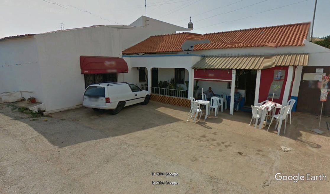
Cafe Elias
The Walk.
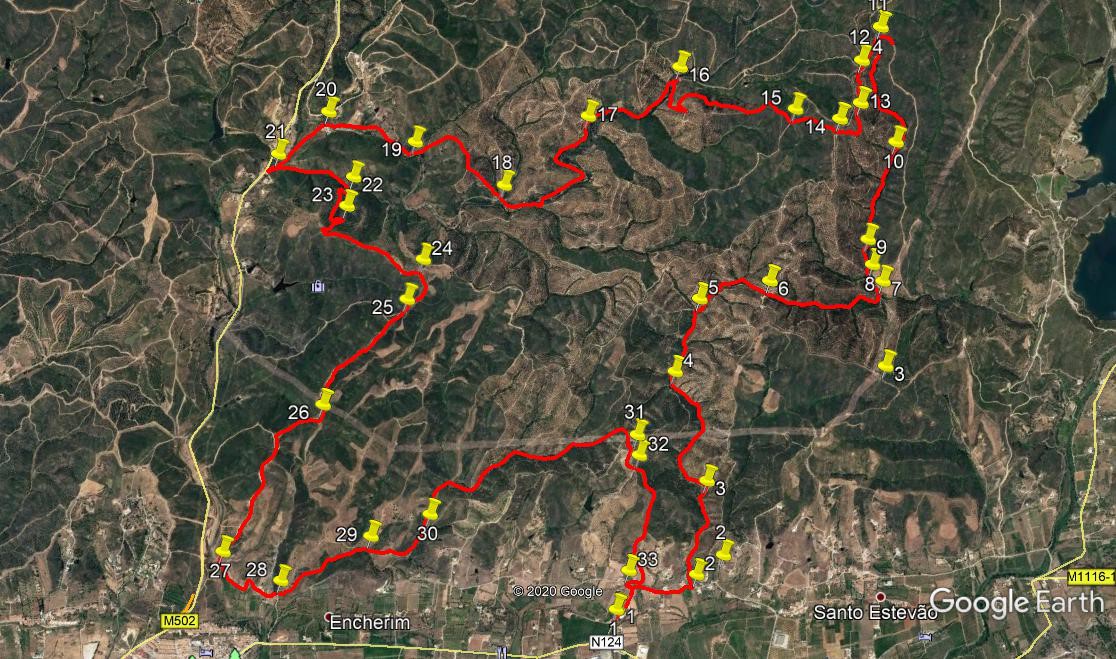
With your back to the cafe (1), turn left and walk along the road to a T junction. Turn right here and walk 390m to the first turn on the left (2). Turn here and walk due north, soon passing under an aqueduct carrying the levada from the Barragem do Arade along the valley. The road becomes a track, and 180m further on, stay left at a fork. After another 340m, rising fairly gently, take a track on the left that quickly swings round to the west. (3). Follow the track as it winds through a valley, undulating gently, for 920m, coming then to a junction.(4). Bear right and continue rising steadily just east of north for a further 500m.(5).At this junction bear right to walk north east, but soon veer eastwards to describe a wide arc over 510m, coming then to a cross-tracks(6). Go straight ahead here, and begin to descend slowly over the next 800m, sticking to the valley all the way.
At a point where the track turns through 90 degrees to the right,(7), turn off left on a narrower track heading north west. Ignore two tracks heading off left uphill after 130m (8) and a further 160m (9), proceed due north to a third junction after another 640m (10), climbing steadily, and go ahead once more as the track leads north, then west, then northwest,and finally just west of north, to reach a junction with a track coming up from the left after another 830m. (11) A short detour to the right here will take you to a trig point and an excellent view. Then return to point 11. Take the track opposite the one to the trig point, heading due south. After 230m, come to track junctions (12) and take the second left, heading east of south, on a ridge. After 280m, stay right at a junction (13), and then swing round almost in a semicircle over the next 240m to reach (14) at a cross-tracks. Now heading west, walk on for a further 300m to another major junction at (15).
Stay right here, and walk on for a further 340m, then fork right to follow a convoluted route round the hill to the left. After c500m, walk into a short side valley and where the track turns to head due south, do a hairpin turn to the right and head west downhill. Turn north with the track after 100m, and follow this down to the valley floor near a building after another 180m (16). Turn sharp left here to follow the valley track, heading roughly south west. After 730m, stay left at a fork (17) and continue descending very gently. Over the next 1.1k, the track goes through two bends, then comes a straight stretch, and finally a shallow curve to the right before coming to a fork (18). Take the right hand track and climb again for a time before starting to descend. Go through a wide curve to the left and then drop steeply down to a wide track, 810m from point 18. (19). Turn right along the track and after 620m, come to the hamlet of Cabeca Branca (20).
Stay on the main track as it runs south westwards to within sight of a tarmac road at Bastos.(21). Less than 100m from the road, hairpin left up a track heading first north east and then south east over the next 520m. Arrive at a track junction (22), and take the right hand, heading due south. The track climbs through two bends, then straightens due south for a while, then turns north east again. 100m after this last turn (23), turn sharp right to walk south westwards for 140m, still climbing. Now swing sharp left and continue to climb gently for another 200m, before finally reaching more or less level ground. After another 500m of undulating track, reach a major junction (24). Swing right here and head not far off due south. Stay left a at fork after 200m (25), and continue south for a further 900m to a fork (26). Take the right hand, and head first south west then due south, descending quite quickly down towards the valley and a river. After 1.2k come to a major track junction by the river, with buildings ahead and left. (27).
Take the left hand track to pass to the right of the buildings, and stay on this track as it winds through the valley, passing more buildings on the left. After the third group of houses, the track descends to a cross-tracks (28). Go straight across here, and ignore a fork to the left after a short distance, to walk along the valley for 680m, coming then to a junction with a track coming in from the left. (29). Continue north east then north for another 470m, staying left at a fork (30). The track continues north for a short time before settling to a more northeasterly course over the next 1.7k. At the end of this, the track describes a semicircle to face southeast and comes to a junction with a track coming in from the left. (31). Turn right here and walk south then east to arrive at another complex junction. (32) Take the second turn to the right, going more southeast than south, and after 210m, turn due south and follow the track as it wanders down to a tarmac road. At the road junction (33), turn left to cross the levada, then shortly turn right to walk down the road back to the cafe and your car.
GPS Points (37/8)
| 1 |
Cafe Elias |
12 |
36 |
64 |
|
24 |
15 |
90 |
|
|
| 2 |
Turn off road |
12 |
49 |
28 |
|
24 |
01 |
32 |
|
670m |
| 3 |
Fork |
13 |
07 |
63 |
|
24 |
09 |
16 |
|
670m |
| 4 |
TTurn north |
13 |
25 |
48 |
|
24 |
29 |
71 |
|
940m |
| 5 |
Bear right |
13 |
40 |
52 |
|
24 |
30 |
46 |
|
510m |
| 6 |
Cross tracks |
13 |
49 |
69 |
|
24 |
16 |
68 |
|
540m |
| 7 |
Nw at junction |
13 |
59 |
45 |
|
23 |
49 |
79 |
|
810m |
| 8 |
Left turn 1 |
14 |
01 |
56 |
|
23 |
54 |
04 |
|
130m |
| 9 |
Left turn 2 |
14 |
05 |
79 |
|
23 |
57 |
87 |
|
160M |
| 10 |
Left turn 3 |
14 |
25 |
62 |
|
24 |
01 |
94 |
|
650m |
| 11 |
Cross tracks/trig point |
14 |
44 |
11 |
|
24 |
18 |
55 |
|
840m |
| 12 |
Cross tracks |
14 |
36 |
73 |
|
24 |
18 |
92 |
|
220m |
| 13 |
Fork R |
14 |
28 |
85 |
|
24 |
15 |
05 |
|
270m |
| 14 |
Cross tracks |
14 |
24 |
18 |
|
24 |
18 |
16 |
|
230M |
| 15 |
Fork R |
14 |
20 |
98 |
|
24 |
27 |
83 |
|
300m |
| 16 |
Hairpin left |
14 |
22 |
57 |
|
24 |
29 |
14 |
|
1.15k |
| 17 |
Fork L |
14 |
04 |
58 |
|
25 |
15 |
83 |
|
740m |
| 18 |
Fork R |
13 |
45 |
25 |
|
25 |
28 |
13 |
|
1.1k |
| 19 |
Join from L |
13 |
45 |
42 |
|
25 |
53 |
43 |
|
790m |
| 20 |
Turn SW |
13 |
43 |
77 |
|
26 |
16 |
84 |
|
610m |
| 21 |
Hairpin L |
13 |
31 |
67 |
|
26 |
23 |
96 |
|
420m |
| 22 |
Turn south |
13 |
33 |
70 |
|
26 |
03 |
58 |
|
520m |
| 23 |
Sharo turn SW |
13 |
27 |
68 |
|
26 |
01 |
84 |
|
400m |
| 24 |
Turn SE at junc. |
13 |
24 |
28 |
|
25 |
38 |
37 |
|
870m |
| 25 |
Fork L |
13 |
15 |
60 |
|
25 |
37 |
92 |
|
310m |
| 26 |
Fork R |
13 |
01 |
63 |
|
25 |
38 |
78 |
|
880m |
| 27 |
Fork L |
12 |
12 |
75 |
|
25 |
54 |
54 |
|
1.26k |
| 28 |
Cross tracks |
12 |
12 |
18 |
|
25 |
37 |
91 |
|
510m |
| 29 |
Join track from L |
12 |
28 |
29 |
|
25 |
21 |
52 |
|
690m |
| 30 |
Stay L |
12 |
37 |
51 |
|
25 |
10 |
13 |
|
460m |
| 31 |
Sharp R |
13 |
10 |
27 |
|
24 |
30 |
77 |
1.7k |
32 |
| 32 |
Cross tracks |
13 |
06 |
66 |
|
24 |
28 |
33 |
|
170m |
| 33 |
Tarmac |
12 |
43 |
84 |
|
24 |
17 |
66 |
|
950m |
| |
End |
|
|
|
|
|
|
|
|
310m |