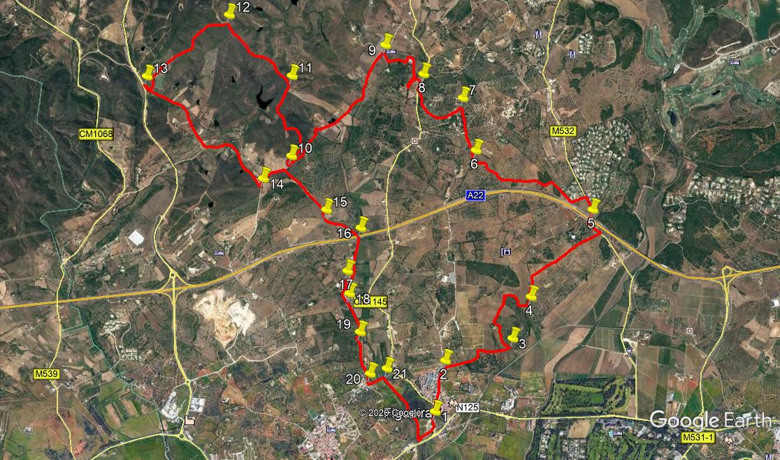
Walk Thirty Six. Figueira - Poio Circular. 19.5k. Ascent: 420m
GPS: 37/ 09.39.80 8/ 36. 07. 66
This walk is relatively easy in terms of ascent, but it still takes in a variety of scenery and pathway types. Starting from the village of Figueira, just off the N124 north of Alvor, it circles a wide area of fairly flat, open land to the east and north of the village. A loop, which can be left out if desired, takes in some higher ground to the north-west, before returning via an interesting walk along a levada (narrow irrigation canal) and a riverside track. Navigation is a little tricky in places, so careful attention to the notes is required! Thanks to Linda and Russell Morris for working out this route.
Getting to Figueira.
From east or west, use the A22 and come off at the Alvor exit. Turn right along the N124, past the Penina golf resort, and drive for 2.9k. Take the second exit to Figueira on the right, and drop down the hill. Park opposite the village social club when you reach the bottom, facing the football ground. The club will not be open if you are walking early, but it will be available on your return. It is perhaps the cheapest bar in the Algarve, so do take advantage!
The Walk.
Facing the social club, (1) turn left and walk up the hill into Figueira village. If you feel the need for a coffee, there is a cafe on the left when you reach level ground, about 500m from the start. From here, walk a further 120m and take a lane on the right, (2) with rubbish bins on the left hand side.After 180m, the lane tuirns sharp right, but you need to go straight on, along a footpath with an orange grove on the left. At the end of this, carry straight on as the land on the left becomes a planted field, and the path widens and edges round it.Turn sharp right by a building and at the next junction soon after, turn right along another wide track, about 350m from the start of the orange grove.
After a further 300m, come to a junction and turn left (3). Now follow the track along the edge of an open field, with a hill of scrub on the right.After 460m, cross a section of open land on both sides, heading for another patch of scrub. Work round this, describing a semicircle, ending up heading more or less south-east. 290m after hitting this area of scrub, pass a track on the right, and almost immediately take a narrow path on the left, with an old wall on the right. Follow this straight ahead for just over 100m, going under trees, to reach a wider track at a junction.(4) Turn left. Passa building on the right, with others away on the left, and after 310m, swing right with the path to cross an open field diagonally for another 330m. Join a more obvious track and continue straight ahead along it. After 570m, arrive at a tarmac road running alongside the motorway. Turn left and cross the motorway on the tarmac (5).
Follow the road for 240m, then turn left along a lane with a cul-de-sac sign. Turn sharp right with the lane after 160m. After a further 170m, the lane ends at a house, and turns into a rough track between bushes. Follow it as it winds through open land for another 320m, ending at a junction with a walled track leading to a ruin away to the right. Cross this and head due west along a rough track for another 230m, joining a more obvious farm track coming in from the right. Where the track bears right towards a farm after a short distance, bear left on a rough path to skirt round south of the farm, rejoining the main track after 130m. After another 320m, skirting another farm in the process, arrive at a junction with a dirt road and turn right, heading almost due north (6). After 130m, where the road turns sharp right, carry on northwards along a footpath across scrubland, with cultivated fields on the left. Cross a tarmac road and continue on the same heading, now with scrub on both sides, finally reaching another tarmac road. (7).
Turn left here and walk down the road through a hamlet. After 110m, go left and then right round a building facing you, and almost immediately take the left hand at a fork. Follow this road as it turns into a dirt track after less than 100m,descending gently. After a further 200m, find a narrow rocky path on the left, still descending, and follow it down to a tarmac road. Take care on the last part of this descent, which is quite narrow, with a drop on the left. Turn right along the road and walk to a house a short distance away on the left. (8) Turn left steeply downhill before the house, and follow the track as it turns left at the bottom. After c100m, the track crosses a bridge over a stream (or dry bed). Over the bridge turn sharp right to walk along the other side of the stream for around 130m, after which veer to due north and walk along the footpath for another 200m, passing polytunnels at the end. Come to a junction with a wider track and turn left.
At the next corner, turn left again and walk towards buildings ahead. Turn right in front of the buildings and walk west, roughly towards a lot more polytunnels up and to the right. Walk round two sides of a large open field, first south of west, then northwest, to reach a wide dirst road, with the polytunnels over on the right. (9) Turn left and walk along this road for 1.7k. Descending a long hill, find a track on the right leading off steeply uphill, heading first due north, then veering north easterly. (10)
NOTE. This is a loop. If you wish to avoid this steep climb, and over 5k of the walk, you can instead walk a few metres down the road and take a track on the left which will lead you down to point 15.
To continue, climb the steep slope, which becomes less steep after a while, for around 1.1k. Note a reservoir (barragem) in the valley on your left. Join a track coming in from the right,(11) and continue to the summit of the climb, now very gently. From here, walk for almost 1k along a ridge, northwesterly, with the land sloping away on both sides. Reach a point with a three way junction, (12) and turn left to follow the track due west, now walking through tree plantations. Follow as the track turns southwesterly and begins to descend. After just over 1.2k, passing a barragem on the left, come down to the valley floor at a wide dirt road, with a tarmac road just beyond.(13). (Just before this junction, there is a deserted cottage, half restored, which makes a good lunch spot).
Ignore the tarmac and follow the track as it heads away south easterly on level ground. After 1k, turn left at a junction, and walk for a further 800m, descending at the end, to a junction (14). Turn sharp left here and walk down into a depression for 330m. You are now a few metres from point 10, and the end of the loop. Take the track on the right before the start of the loop, and follow it down into the valley. After 700m, emerge onto a dirt track (15) that quickly turns into a hard surfaced road. Walk along this as it passes over the A22 motorway, (16) and continue beyond this for a further 460m, due south, to find a turn to the right up a dirt track, with a field full of junk on the left.
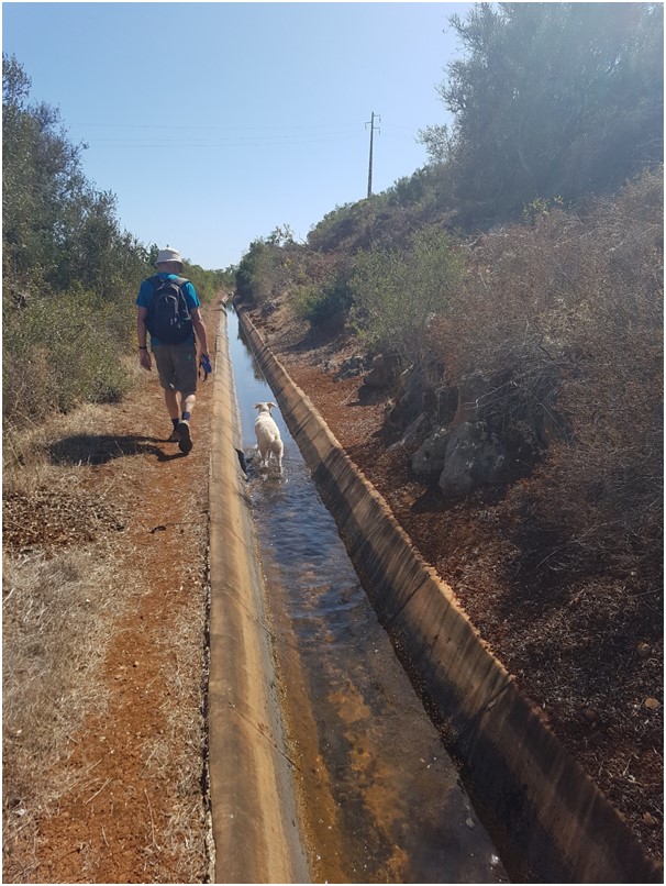
Man with friend by (and in) the levada.
100m up the lane, where it turns left, drop down instead onto a track by the side of a narrow water course (levada) (17). Walk along the levada for 660m, crossing three tracks/roads in the process (Point (18) is the third of these), and reach a point where the levada disappears underground. Walk along the track above the levada route, and descend into a slight depression. See a farmhouse ahead, and climb up to the right well before it to rejoin the levada as it emerges.(19). Now continue along it for another 300m, cross a road and rejoin for a final 160m, emerging on the road once more.(20) Walk a few metres to a wider tarmac road and turn left downhill. Take the first turn on the right (21) and walk for just over 800m by the side of a tidal river. Just before the track climbs to a main road (the N125), drop down to cross the ditch on the left, and climb up onto level ground. You can now see the football field and the sport club ahead. Walk straight across the open ground to the club and your car. Don´t forget to take advantage of the cheap drinks!
GPS Points
| 1 | Figueira Club | 09 | 39 | 80 | 36 | 07 | 66 | |||
| 2 | Turn off right | 09 | 57 | 80 | 36 | 04 | 18 | 570m | ||
| 3 | L in scrub | 10 | 06 | 15 | 35 | 35 | 23 | 830m | ||
| 4 | L by farm | 10 | 20 | 83 | 35 | 27 | 93 | 960m | ||
| 5 | Motorway | 10 | 51 | 76 | 35 | 02 | 76 | 1.41k | ||
| 6 | Turn onto lane | 11 | 10 | 77 | 35 | 54 | 25 | 1.64k | ||
| 7 | Onto tarmac | 11 | 28 | 73 | 36 | 00 | 76 | 630m | ||
| 8 | L by house | 11 | 36 | 43 | 36 | 18 | 21 | 770m | ||
| 9 | L on wide track | 11 | 45 | 84 | 36 | 35 | 18 | 970m | ||
| 10 | Turn to loop | 11 | 06 | 44 | 37 | 14 | 11 | 1.69k | ||
| 12 | 3 way | 11 | 54 | 15 | 37 | 43 | 00 | 970m | ||
| 13 | Hairpin by tarmac | 11 | 32 | 08 | 38 | 17 | 55 | 1.26k | ||
| 14 | End of loop | 10 | 58 | 35 | 37 | 25 | 99 | 1.82k | ||
| 15 | Tarmac | 10 | 48 | 33 | 36 | 58 | 11 | 1k | ||
| 16 | Motorway | 10 | 42 | 49 | 36 | 42 | 97 | 420m | ||
| 17 | Levada | 10 | 27 | 45 | 36 | 48 | 02 | 330m | ||
| 18 | 3rd road | 10 | 19 | 63 | 36 | 46 | 80 | 270m | ||
| 19 | Break in levada | 10 | 06 | 56 | 36 | 41 | 44 | 470m | ||
| 20 | Off levada | 9 | 52 | 25 | 36 | 36 | 54 | 470m | ||
| 21 | Turn to river | 9 | 54 | 02 | 36 | 29 | 27 | 220m | ||
| End | 1.1k |