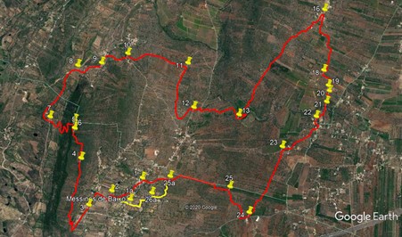
Walk Forty Three. Messines de Baixo - Monte Brito Circular. 21k
Ascent: 550m
The first part of this walk, starting from near Sao Bartolomeu de Messines, is quite challenging, involving a climb to a ridge with spectacular views as a reward, followed by a steep descent at the other end. After that it becomes far less difficult, with a long gentle descent followed by a ramble through undulating land dotted with orange groves. There are refreshments both at the start and at around two-thirds distance. There is a stream bed to negotiate on the final stage, which involves a bit of scrambling, so be prepared for that. After heavy rain, this stream could be difficult to cross.My advice would be that those less agile should think twice about tackling the walk.This walk has the added benefit that the start is easy to find! To help other walkers, it would be useful if you could carry a pair of secateurs on this one, as a small amount of path clearance might be needed.
Getting to Messines de Baixo.
From the west, either use the A22 motorway and turn off on the A2 Lisbon motorway to come off at Messines, or the N124 from Silves. From the A2 motorway junction, turn left at the roundabout from the A2, or right coming from Silves, heading for Alte/Salir. Go up the hill under the motorway and take the second off at the small roundabout near the top. Drive on for 1.3k to find the Bar Paragem (Bus Stop Bar) on the right, where pre-walk drink may be had. 400m further along, turn left and park on the area of rough ground to the left of the side road.
From the east and south, use the N124, joining it at either Salir or Benafim from the A22 at Loule or Boliqueime. Go past Alte and Monte de Charneca. Go round a sharp right hand bend and then a left-hander, and find the rough ground 350m along on the right, with the bar a few hundred metres along on the left.
NOTE. You can start to walk either from the bar or from the rough ground
The Walk.
From the rough ground, (1) turn left up the narrow road and walk for 270m. Find a narrower tarmac lane between buildings on the right, and walk along it for 100m, taking the left hand at a junction. Follow this winding lane for just over 200m to a junction and turn right on a wider lane. (2) After 120m, turn left at a T junction, and then right at the next junction after 100m. Walk past a farm on the left and after 220m, turn left at yet another junction. Now follow the road as it turns into a dirt track. After just over 300, take the right at a fork, (3) and start to climb a wide stony track.
To start from the bar, cross the road and take the narrow lane heading north on the other side. After around 100m, turn right, then left and walk for another 100m to a junction with a track on the right. This is point 2, so follow the main instructions from here by walking straight on.
This track winds uphill, moderately steeply, for 800m, to reach a plateau. Follow it as it heads almost due east for another 1k, to reach the edge of a cultivated area, mainly olive trees (4). Follow the tractor track across this section, keeping the wall on the right in sight, and exit the grove at the top right-hand corner, coming back onto a clear dirt track. After another 160m, the track turns sharply to the left and climbs a bit. !00m on, it turns right, and after another 190m, come to the edge of another, rather less organised, area of cultivation (5)
Walk across the area, keeping close to the tall vegetation on the left. Come very soon to an old broken wall, and find a narrow, overgrown footpath leading off in the same direction you have been following. (If you can´t find this, look on the wall for the place where others have gone over, with lighter coloured stone). Follow this path carefully (it is a bit prickly too!) for around 120m. crossing more broken down wall fragments. Come to a point where a footpath goes off to the left, down into the bushes.(6) (I left a small rock cairn here, but don´t rely on it still being there). Follow this very narrow footpath steeply down through the belt of trees and bushes. (You should be able to see quite easily where it has been cleared, but it would be helpful if you could cut down any brambles or small shoots that have sprung up).
Come down to a level area with a few pine trees. Walk straight forward and find a tractor track heading steeply downhill. Follow this down to a junction with a track heading west across the hill. Now follow this rather overgrown track down as it winds towards the valley floor. Come to a point near the floor where you are facing a house below. Turn left with the track and make your way round the house in the field, to join the track leading to it at the field corner on the northern side. Now follow the track up to join a much wider gravel road at a junction. (7) Turn right, and follow the road for around 1k, passing new build holiday homes on the left, followed by a bank of solar panels, and a large house down on the right.
1k from the turn onto the gravel road, arrive at a junction with a track coming in acutely from the left, and carry straight on past a house on the left. Drop down into a wide valley and take the first turn on the right, (8) across one side of the valley and up the hill. At a divide in the track after 140m, take the left hand, which starts between trees and then goes into open country, passes through a plantation and ends up at a junction between buildings 320m from the divide. (9) Turn left here and walk about 220m into Fonte Santa, arriving at a tarmac surface. Turn right here and almost immediately leave the tarmac to walk down a track going south between fields for 370m, arriving at tramac once more. (10) Here do a ´dog leg´ left and then right to enter another track heading south. Follow this for just over 1k to a T junction with another track. (11) Turn right here and walk roughly west for almost another 1k. At the next junction turn left and walk a couple of hundred metres to reach the N124 just east of Monte de Charneca. (12)
Turn left along the main road and walk for 170m, then take a track on the right going back at an acute angle from the road. After a short distance, the track turns southwards and heads through several bends down into a valley over the next 700m, with orange groves mainly on the left. Now the track turns right, southwestwards. Walk for just over 200m, then take a track on the left between groves (13). This descends to a stream. Cross over and swing sharp left uphill, going round to the right find a track on the right between rows of orange treet, heading quite steeply uphill. Follow this to the top to face a low wall. (14) Turn left and then almost immediately right on a dirt track heading southeast. After around 400m (15) the track becomes a more obvious donkey road between walls, and this lane takes you all the way to the village of Monte Brito, 1.9k away. (16)
At Monte Brito, you have a choice. Turning left along the main road will bring you shortly to the village bar. If refreshment is not on your mind, turn sharp right and walk for 100m before going straight ahead onto a track. After 210m, turn left down a track past a house. Walk round the gate at the end back onto the road and turn right. After 250m and round a bend, take a track on the right (17) 500m along come to a T junction. (18) Turn left here. The next section involves some tricky navigation. Walk for 180m, past a broken wall on the right. Soon after find a tractor track on the right running between cultivated areas. Follow this across the land for 140m, as a wall appears on the left. Cross over a broken wall at the corner and head across open land in the same direction for a short time to come to a dirt track with yet another orange grove facing you. (19)
Turn left downhill to find a wide than average track between rows of trees, and follow it uphill to a junction. Turn left again, and after less than 100m, find a place to scramble up the bank on the right (20) Cross over another narrow section of rough ground and come to the corner of another grove. Walk down the left hand side of the grove to come to the valley floor. (21) Turn left in front of the trees and walk for a short distance to find a way over a hump of rock and soil to look down into the stream bed. There are two or three points to cross, but the most straightforward is here. Go down carefully to the right and climb out the other side with the help of the tree almost immediately opposite.
Cross the open ground in front of you, heading due east, and find the beginning of a donkey track that will take you quite steeply uphill to the village of Arieiro after 300m. Arrive at a tarmac road and turn left (22) Follow the road as it turns left, and at a junction with another tarmac surface turn right. Walk along this road for 840m. Shortly after passing a rather interesting estate with a house like a swiss chalet, turn left on a gravel track.(23) Follow this, just north of west, for 1.3k to come to another tarmac road with the entrance to a property across and right (24) Turn right and walk for 160m and turn right onto another dirt track.
This winds across flat land for almost 600m before turning north alongside an orange grove.(25) Soon after this it turns right through the grove and then shortly it turns northwards again, a few metres from the grove on the other side. After 600m, the track bends to the left, and soon after there is a choice to make, depending on where you started the walk.
To go back to the rough ground by the main road, simply carry on up the track you are on. To go back to the cafe, take the first left after the track turns north again. After 200m, (25a) turn left and follow the track downhill and round to the right. Turning northwards, the track becomes a little less obvious, but still clear enough, ending after 350m at a wide lane with a farm on the right. Turn left, left again and then right (26a) to head up a lane with properties on the right. Over the next 200m, the road kinks left and right again in the middle. Turn left with the road at the next corner, with a large property in front, and walk between houses, turning right at the next junction. Now follow the road straight up to the N124 and the cafe.
GPS Points: 37/8
| 1 | Rough ground | 14 | 21 | 65 | 14 | 01 | 19 | |||
| 2 | Turn left | 14 | 36 | 47 | 14 | 13 | 37 | 690m | ||
| 1a | Bar | 14 | 25 | 86 | 14 | 17 | 05 | |||
| 1a - 2 | 350m | |||||||||
| 3 | Fork right | 14 | 17 | 11 | 14 | 25 | 83 | 620m | ||
| 4 | Straight on | 14 | 55 | 50 | 13 | 54 | 84 | 1.74k | ||
| 5 | Straight on | 15 | 01 | 92 | 13 | 35 | 58 | 610m | ||
| 6 | Left thro wood | 15 | 02 | 69 | 13 | 30 | 24 | 130m | ||
| 7 | Turn right | 15 | 18 | 02 | 13 | 31 | 52 | 950m | ||
| 8 | Turn right | 15 | 07 | 94 | 12 | 52 | 81 | 1.18k | ||
| 9 | Turn left | 14 | 55 | 230 | 12 | 48 | 21 | 470m | ||
| 10 | Left and right | 14 | 42 | 31 | 12 | 38 | 09 | 610m | ||
| 11 | Turn right | 14 | 08 | 67 | 12 | 36 | 20 | 1.13k | ||
| 12 | Turn left | 14 | 00 | 79 | 13 | 06 | 16 | 1.31k | ||
| 13 | Turn left | 13 | 35 | 32 | 13 | 05 | 22 | 1k | ||
| 14 | Left and right | 13 | 31 | 06 | 12 | 54 | 19 | 500m | ||
| 15 | Straight on | 13 | 28 | 42 | 12 | 39 | 57 | 410m | ||
| 16 | Turn right | 12 | 58 | 70 | 11 | 39 | 96 | 1.85k | ||
| 17 | Turn right | 12 | 50 | 72 | 12 | 03 | 58 | 760m | ||
| 18 | Turn left | 12 | 52 | 82 | 12 | 22 | 76 | 510m | ||
| 19 | Turn left | 12 | 48 | 84 | 12 | 32 | 84 | 370m | ||
| 20 | Turn left | 12 | 47 | 87 | 12 | 36 | 40 | 150m | ||
| 21 | Stream crossing | 12 | 48 | 08 | 112 | 44 | 43 | 250m | ||
| 22 | Turn left | 12 | 52 | 59 | 12 | 56 | 20 | 370m | ||
| 23 | Turn left | 13 | 08 | 40 | 13 | 21 | 46 | 970m | ||
| 24 | Turn right | 13 | 19 | 88 | 14 | 10 | 82 | 1.32k | ||
| 25 | Turn left | 13 | 33 | 35 | 13 | 56 | 20 | 730m | ||
| End rough ground | 1.65k | |||||||||
| 25a | Turn left | 14 | 06 | 57 | 13 | 56 | 46 | 1.11k | ||
| 26a | Turn left | 14 | 14 | 86 | 14 | 10 | 45 | 560m | ||
| End bar | 520m |
Note: On this photo, north is left.