Walk Sixty Two. Ribeira de Algibre Circular. 19k. Ascent: 530m .
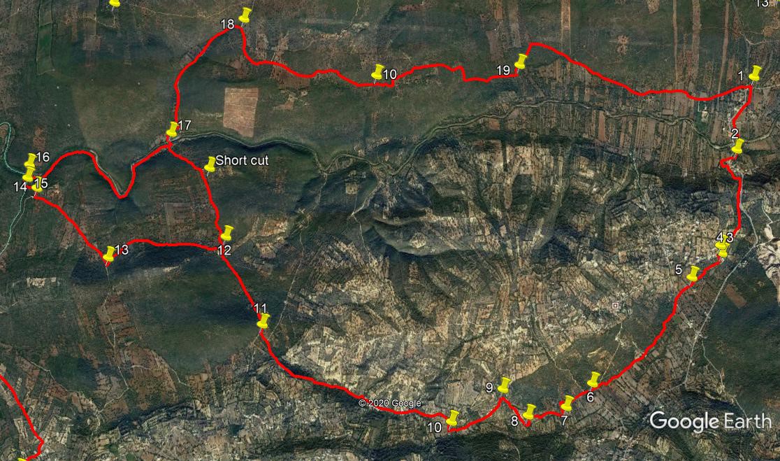
This walk starts from the same place as two other routes in this series, but is rather more gentle than either of the others. Starting from the outskirts of Ribeira de Algibre, it contours the hills around Monte Seco, following clear paths on mostly level ground, to link up with the trail between Alfontes and Espargal for a time. Then a loop takes in a rocky descent back to the Algibre valley, followed by a single file walk under trees along the south bank of the river. A kilometre of road leads steadily uphill, and then a turn to the right finds a trail taking you straight back to the start, involving one further gentle climb.
Getting to Ribeira de Algibre.
From the A22 motorway, take the Boliqueime exit and follow signs for Loule. Go up past the quarry and take the first left into the village of Parragil. At the T junction turn left and follow this road downhill to the valley floor. Cross the narrow bridge and around 400 metres further on find the Bar Reguengos on the left - it is the very last building in the village. Park just beyond the bar on the left. Those coming from the west on the N124 need to turn off at Benafim, taking the right fork signed to Loule, Boliqueime and other places. Follow the road into a hollow and then up to Alto Fica. Then descend again to Ribeira de Algibre, finding the bar on the right immediately after the junction with the road to Tor.
The Walk.
With your back to the bar (1) turn right and walk down through the first part of the village. Cross the narrow bridge over the river (usually bone dry) and take the first turn to the right down the side of a building (2).After 100m, turn left up the side of a smallholding and pick up a rather indistinct path leading south south east, more or less parallel to the tarmac road on the left. After around 170m, the track enters woodland and then turns left for a short distance before veering right and running due south. Now follow this track for 700m, rising gently, finally reaching a house (3). Pass in front of the house, and where the track turns sharp right, drop down to the left and work round the edge of a small ploughed or cultivated field. Follow a cart track down at the left ahd corner of the field and enter an area bare of trees with light coloured soil. Drop down this area to reach a cart track running left to right and turn right along it (4).Walk along this for 380m to find a lane leading down to a house on the left (5). Continue on the now improved lane to the junction with a tarmac road after a further 170m.
Turn left and very shortly right along a broad dirt track.Walk along on level ground. After c1k, pass a track coming in from the right, and about 140m further on reach a junction with a track going left (6). Continue straight ahead; ignore a turn right after c100m. After about 300m, the track turns sharply left. Just over 100m further on take a turn to the right along another dirt track.(7). After 190m, come to a point where the track circles a tree, then continue to the edge of a small grove of olive trees. Either cross this in the middle (there is a faint track) or work your way round the edge to the right, and pick up a clear dirt track again at the other side, heading almost due south. This ends very soon at a junction with a broader track (8). Turn right here (north west) and walk for 330m to a nother track junction (9). Turn sharp left at this one and walk for a further 550m, turning very gently from south west almost to due west, to reach another junction (10), where you should turn right. Walk due north for 110m, then turn left on a slightly less well surfaced track, and follow this for c1.6k, dropping into a shallow valley. At the end of this section, ignore a track coming in from the left and continue for another 300m, passing a track on the right, to come to a T junction with a broad dirt road (11).
Turn right along this road, which descends very gently. After around 270m, pass on the left a trio of old charcoal furnaces, probably disused now. Continue for a further 590m, passing one track on the right and one on the left. On a left hand bend, find another track on the left (12). Here you have choice. By continuing straight along the track, you will descend to the Algibre river after just over 1k, avoiding a 4k loop and a steep descent to the river. You would then be at Point (17). However, the loop is one of the most attractive parts of the walk, so unless fatigue is a factor, it would be a pity to miss it.
For the loop, turn left at (12), and follow this track to a junction after 1.13k. Turn right here, passing a turn to the left after 280m, and coming to a curve to the left after another 650m.(14) Here see quite a wide open space with some track mending materials. Immediately before this find a rather overgrown track on the right, and follow it. It goes due north for a short diStance before curving round to the west and starting to descend. Go very carefully down the rocky path as it drops into a stream valley (15). Turn right downstream and emerge onto the bank of the Ribeira de Algibre (16). Now turn right and follow the narrow footpath above the river bed for 1.8k, as it describes two large curves. The whole section is shaded by trees. Emerge onto a more open area, and follow to a point where the river is forded (17) Across the ford you will see the beginning of a tarmac road. This is a good place for lunch or just a short rest.
To continue, cross the river, or dry bed, at the ford, and follow the tarmac road first up a short steep slope, then on more or less level ground, and finally up another longer steepish section for around 1.4k, to find a dirt track leading off to the right.(18). With only one unexpected turn, this will take you back to the start. Staring off due south, the path gradually turns eastwards. After about 1.6k, it starts to climb gently over the top of a broad hill. A further 1.4k, involving a descent down a rather stony lane, come to a junction where the left hand leads uphill, (19) and take this for 300m before turning right to resume the downward trend. From here, follow this track for a further 2.1k. It turns into a tarmac surface eventually, and ends opposite the junction with the Tor road. Turn right to walk the few metres to the bar.
GPS
| 1 | Cafe Reguengos | 11 | 27 | 55 | 05 | 00 | 46 | ||||
| 2 | Leave main road | 11 | 09 | 66 | 05 | 05 | 73 | 690m | |||
| 3 | Turn off track | 10 | 42 | 27 | 05 | 12 | 05 | 1k | |||
| 4 | Join cart track | 10 | 39 | 49 | 05 | 11 | 88 | 100m | |||
| 5 | Join dirt road | 10 | 32 | 85 | 05 | 22 | 59 | 340m | |||
| 6 | Track junction | 10 | 03 | 67 | 05 | 57 | 97 | 1.33k | |||
| 7 | Right turn | 09 | 57 | 07 | 06 | 07 | 57 | 390m | |||
| 8 | Join track from left | 09 | 54 | 88 | 06 | 20 | 89 | 370m | |||
| 9 | Sharp left turn | 10 | 02 | 11 | 06 | 29 | 29 | 340m | |||
| 10 | Turn right/north | 09 | 53 | 41 | 06 | 47 | 41 | 350m | |||
| 11 | Turn to broad track | 10 | 19 | 89 | 07 | 52 | 84 | 2k | |||
| 12 | Turn onto loop | 10 | 44 | 41 | 08 | 05 | 78 | 850m | |||
| 13 | Right turn t junction | 10 | 38 | 96 | 08 | 47 | 73 | 1.12k | |||
| 14 | Right on overgrown | 10 | 58 | 55 | 09 | 13 | 07 | 920m | |||
| 15 | Stream side | 11 | 01 | 80 | 09 | 17 | 21 | 180m | |||
| 16 | River bank | 11 | 06 | 18 | 09 | 17 | 07 | 130m | |||
| 17 | River crossing | 11 | 13 | 70 | 08 | 25 | 79 | 1.84k | |||
| 18 | Turn off tarmac | 11 | 45 | 51 | 07 | 59 | 68 | 1.4k | |||
| 19 | Turn uphill | 11 | 32 | 26 | 06 | 21 | 41 | 2.9k | |||
| 20 | End | 2.6k |