Walk Forty Five. Monchique Foz de Banho Circular 13k. Ascent: 636 metres.
- The Monchique hills are the highest in the Algarve, and although this walk avoids the high tops, it is still quite challenging, even though the distance is short by the standards of this series. The walk starts at a well known café – restaurant on the main road between Portimao and Monchique. It stands close to Caldas de Monchique, a small spa withhot thermal springs. Caldas is one of the Algarve’s tourist attractions. The walk descends into the Caldas valley to start, and then executes a winding course in the foothills of the Serra de Monchique, with some excellent views over the plain below and the heights of Foia and Picota above. Monchique was badly affected by forest fires in 2018, but the land is already in recovery, (summer 2019) and the pathways open. Walks in this area were pioneered by Ian Wilson some years ago, and this route owes much to his work.
Getting to Foz de Banho.
Leave the A22 motorway at the Portimao exit and follow signs to Monchique. Pass through Porto de Lagos and at a roundabout just beyond, take the N266 to Monchique. Follow this excellent road for 10.5 kilometres, first on level ground and then increasingly steep and winding. Look for a large multi storey building on the right, which is a health resort. Foz de Banho is more or less opposite the entrance to this. Park just down the road from the restaurant and gift shop.
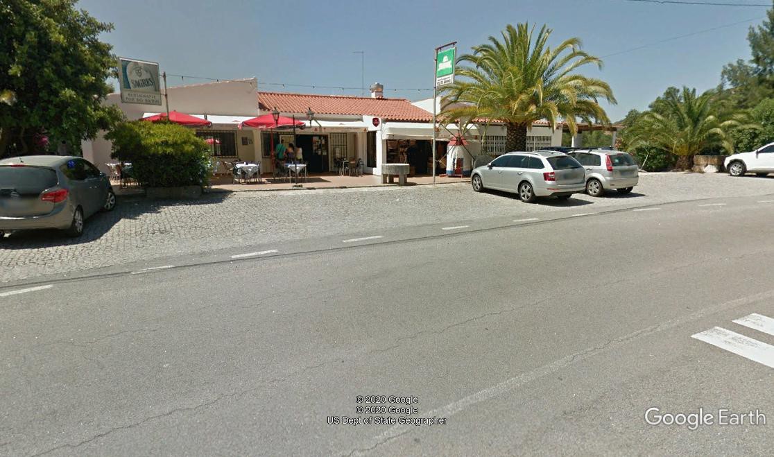
Cafe Restaurant Foz de Banho.
The Walk.
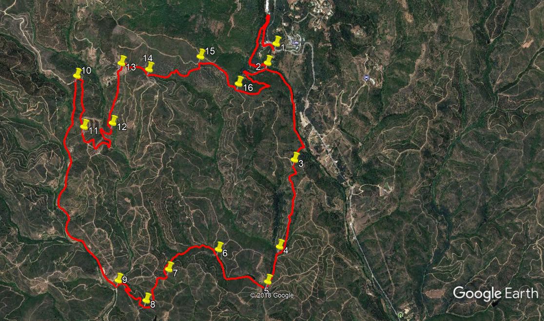
- With your back to the restaurant, (1) turn left and walk to the roundabout just up the road. Here turn left and walk downhill on tarmac for 410 metres. Find a path leading off on the left past a building, and turn sharply into it, continuing downhill for a further 670 metres to reach the floor of the valley at a bridge. (2) (you will return across this at the end of the walk). Now walk straight ahead, to the left of the stream, and continue gently downhill on this narrow track for around 440 metres. Come to a point with a small orchard on the right and a building beyond it. Go straight ahead once more past the building onto what is now merely a footpath (ignore the track leading off to the left), and continue for another 430 metres.
- At this point, the track leaves the valley floor and begins to climb quite rapidly, rounding a low hill on the right, then linking with a wider farm track and heading quite steeply uphill to a junction with an even wider track after 250 metres (3).Turn left here and continue to climb over the next 470 metres, after which the track descends again, with increasing speed, over the next 490 metres (4). Coming to a junction of several tracks here, continue in the same direction (roughly SSW), descending more gently, for the next 360 metres. (5).
- Arrive at a small island of trees, with a track bearing right in front of it, take this and walk along past a small barragem (reservoir), then turn west with the track for a short time, finally bearing round to north west and continuing for 250 metres to a point where a rough track forks left. (6). Ignore this and continue, as the track you are on describes a wide uneven semicircle over the next 730 metres. Ignore all turns to the right and climb steadily to reach a T junction. (7). Now on a ridge, turn right and follow it as it undulates over the next 460 metres to (8). Here, at the end of a short westward facing section, find twin paths heading off right. Take the left hand of the two, rise very shortly to a high point and then begin to descend, eventually going through two hairpin bends and coming to the valley floor after some 530 metres. (9).
- Turn right into a wide dirt road and follow it for the next 2.2 kilometres, passing numerous houses and pieces of cultivated land on the way. The road starts to climb more steeply towards the end of the section, the houses run out, and there is only scrub on either side. (10). As the road describes a tight left hand turn, bear right off it instead, and after a short distance bear right again, and right again at the next junction, to face the way you have come, but still climbing. Walk forward, now due south on a ridge line once more, for the next 530 metres (11).
- The route to the next point is quite complicated, most of it on a downward track. Go forward, almost due south, for 120 metres. At a small island of trees swing round to north east and walk 50 metres, to turn a hairpin right. After a further 110 metres join another track and then follow the second left round another hairpin. The track now describes a wide semicircle for 170 metres to arrive at a cross tracks. Turn left and walk almost due north for 210 metres, levelling out and starting to rise again gently. Reaching yet another hairpin, swing round right, and follow round a wide curve to the left, to reach (12) after another 160 metres, now climbing.
- Here find a fork, take the left hand track and swing round to walk almost due north, climbing fairly gently, for 580 metres, seeing a house below you on the left just before you reach (13). Turn right here to walk in front of a long building, and follow the track for 360 metres, passing more houses and ruins on the way. Arriving at a major junction, with a track leading off left, (14) turn onto this and walk along descending gently, for 630 metres, tending east or north east. At the end of the section turn due north uphill for a short distance to a junction (15).
- Turn right here and start to descend over the next 510 metres, veering round to the south east. At a fork (16) take the left hand path and descend by a winding route into the valley, over 860 metres, arriving at the bridge you saw earlier at Point 2. Cross the bridge and turn left to retrace your steps up the hill and back to the Foz de Banho. (c. 1100 metres).
GPS Points. (37/
| 1 | Foz de Benho | 16 | 45 | 18 | 33 | 13 | 56 | Start | ||
| 2 | Bridge | 16 | 39 | 68 | 33 | 16 | 97 | 1100m | ||
| 3 | Junction on hill | 16 | 09 | 36 | 33 | 07 | 21 | 1.14k | ||
| 4 | Track junction | 15 | 42 | 11 | 33 | 13 | 54 | 960m | ||
| 5 | Turn off right | 15 | 35 | 75 | 33 | 20 | 72 | 370m | ||
| 6 | Track fork | 15 | 41 | 69 | 33 | 37 | 68 | 680m | ||
| 7 | T junction | 15 | 36 | 04 | 33 | 56 | 76 | 710m | ||
| 8 | 3 way junction | 15 | 42 | 85 | 33 | 57 | 16 | 460m | ||
| 9 | Turn on main rd | 15 | 32 | 46 | 34 | 17 | 33 | 520m | ||
| 10 | Head of valley | 16 | 36 | 56 | 34 | 30 | 43 | 2.2k | ||
| 11 | On descent | 16 | 20 | 58 | 34 | 30 | 63 | 630m | ||
| 12 | Track fork | 16 | 21 | 75 | 34 | 17 | 47 | 830m | ||
| 13 | By long house | 16 | 39 | 85 | 34 | 15 | 27 | 580m | ||
| 14 | L turn before descent | 16 | 37 | 77 | 34 | 02 | 43 | 360m | ||
| 15 | L turn to valley | 16 | 41 | 40 | 33 | 42 | 59 | 640m | ||
| 16 | Left fork | 16 | 32 | 97 | 33 | 28 | 29 | 510m | ||
| 2 | Bridge | 16 | 39 | 68 | 33 | 16 | 97 | 880m | ||
| 1 | Foz de Banho | 16 | 45 | 18 | 33 | 13 | 56 | 1100m |