Walk Forty Four. Moinho da Rocha. 15.5k Ascent 615m
GPS: 37// 14.06.54 8// 35.31.44
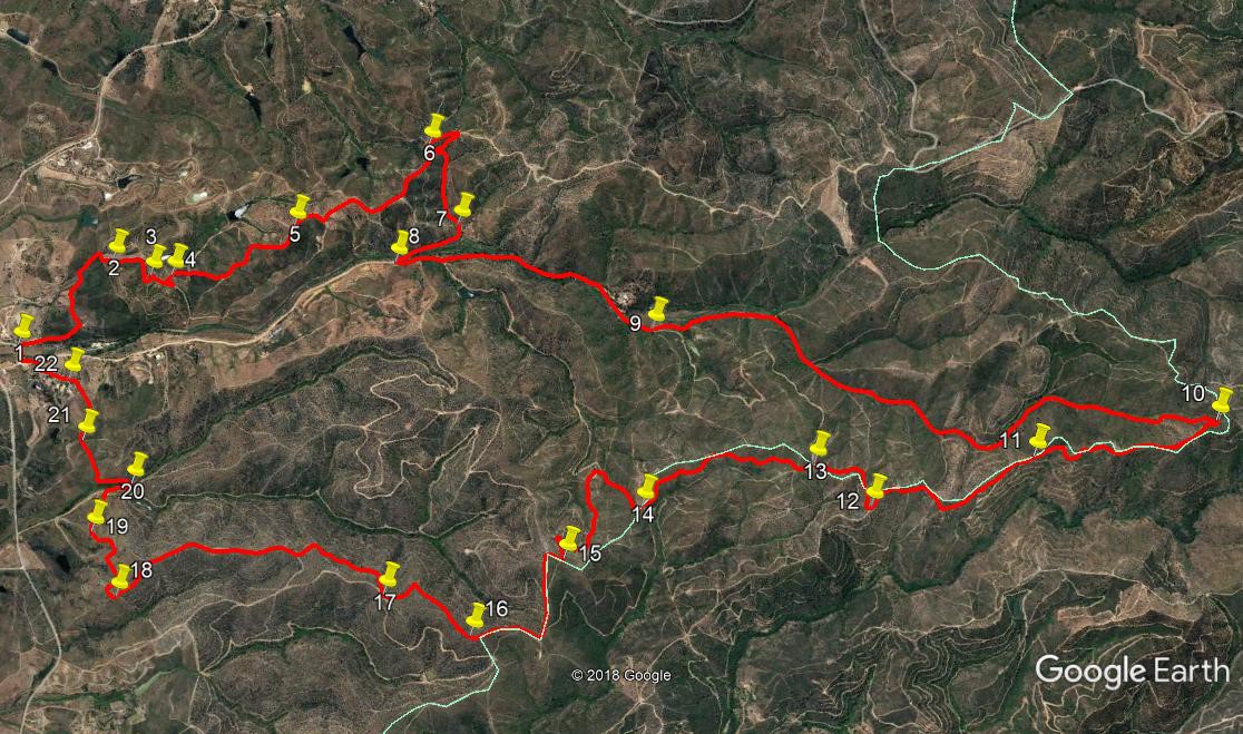
This walk, although quite short by the standards of this list, is nevertheless quite demanding in places. It covers ground to the north of the seaside town of Alvor, on the way up towards the Monchique hills. It follows an undulating course to rise to a high ridge, and returns via that ridge, ending in calm meadowland. The land surrounding the area of the walk was badly burnt in the fires of 2018, but nature recovers quickly here, and the greening has already begun. (summer 2019) There used to be a bar at the start of the walk, but that closed some years ago, so refreshments must be had at one or other of the cafes on the road up to the start point. Several members of the AWW have led and modified this walk over the years, but thanks must go to Hedley White who pioneered it, and Geoff Hill who has made it his own.
Getting to the start.
Whether coming from east or west, the only natural way to get to Moinho da Rocha is from the N125 near Alvor. Come off the A22 at the Alvor exit, and turn towards Lagos on the N125. See a filling station on the right after a few hundred metres, and take the turn to the right immediately after it. Now you must follow this road for 9 kilometres to the bridge at Moinho. Go past an Adega (winery) and through a very narrow point under a bridge. Where the road goes straight on towards a viaduct, bear left and drive to go over the motorway. Now simply follow the main road, past the settlement of Alcalar (small bar with yellow awning), and past other cafes such as O Tasco. Ignore all turnings onto minor roads, and finally come to a point where the road turns left at right angles to cross a bridge. Park on either side. (The building on the nearside used to be the café.)
The Walk.
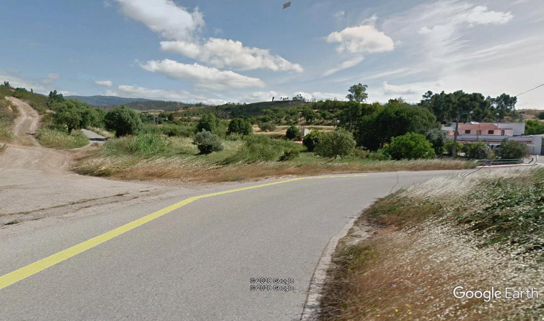
View at the start of the walk.
- Start from the far side of the bridge, and take the path on the right, leading uphill away from the road (1). Climb to a small farm building (abandoned at the time of writing) and swing left in front of it to descend into a small valley, planted with trees. Go straight over at a cross – tracks, and walk round an arc to the right. Next turn left with the path to avoid walking through the plantation in front of you. Walk along the left hand side of the plantation and at the end turn right past the far end of the trees. At the corner, turn left and walk across a slightly indistinct path for 50 metres, to join a much clearer path, heading almost due north. (2).
After just over 100 metres, the path swings round to the right, and a further 100 metres along turns through 180 degrees left (3). Coming up to a junction with another track, turn right and walk forward another 100 metres, then turn through a hairpin left and almost immediately swing right, now climbing steadily. Quickly come to a fork on the right and take it, (4) climbing ever more steeply over the next 260 metres to reach a junction with another track. Here turn left. Now on a ridge, walk forward for around 550 metres over undulating ground to a fork. (5) Go left here.
- Descend slightly before climbing quite steeply again to another fork after 400 metres. Take the left track once more and descend now quite quickly. After around 250 metres, curve right with the track, and after a further 150 metres, swing round a hairpin to the right. (6). Still descending, shortly take another sharp bend to the left, and continue for a further 330 metres to a point where buildings become visible off to the left. (7). Turn away from the buildings and swing round to the right, following the track down to a wider dirt track in the valley after another 300 metres. (8).
- Turn sharp left into this new track. It runs on more or less level ground, due north, for something over 400 metres, then turns slightly east of north and begins to climb gradually. After around 700 metres note dwellings on the hill opposite, and continue on this main track up the valley. (9). A long uphill climb of around 2.5 kilometres brings you out at a T junction on a ridge, with the high points of the Monchique range in sight through the trees. (10). This is a good spot to take a breather, have some lunch, and admire the views.
- Turn sharp right at the T junction and follow the track as it undulates for a while and then starts to descend fairly rapidly to point (11), over a distance of 820 metres. From here, descend more gently for a further 810 metres to point (12). Here swing round through 180 degrees to walk eastwards for a short time, ignoring a track on the left heading more steeply downhill. After 150 metres, the track swings round to the south and arrives at a junction after another 200 metres (13). Stay left here to follow the track, still descending gently, to reach another junction after 840 metres (14).
- Here ignore two tracks on the left, and follow round to the right, now tending uphill and soon turning to face more or less south westwards. After 230 metres, take the left hand at a fork, and walk around a hill to face eastwards over the next 380 metres. Now turn south again, still rising, and after another hairpin bend, climb to a cross tracks after another 230 metres (15). Here turn sharply south once more to reach a high point after another 100 metres or so. Now turn left and start to descend quite quickly on a straight line before flattening out and proceeding to a 90 degree turn right after 350 metres.
- Now walk south for 290 metres, on a gentle rise, reaching another high point at (16). Bear right here and descend gently west of south, then south east and finally south, to reach a major junction after 470 metres. (17). Now take the first on the right, and drop down to a track below the ridge, looking down into a valley on the right. Follow this track for quite a while due south, then turning south easterly, for 1.64k, descending all the time, and arriving at a sharp right hand curve (18). Follow the track round this curving section, descending still, to point (19) after another 390 metres. Now at a hairpin bend in the main track, take the less obvious one on the right, which descends quickly to the valley floor at a ruin.
- Turn right along the valley and after 100 metres, bear left in front of a circular stone feature. (20) Follow the track as it turns through a hairpin left and runs along under the hill. After 140 metres, it turns into a side valley. Cross to the left hand side of this on a now narrow footpath, and climb gradually. The last few metres of this climb are a scramble up a steep slope to a ridge with a track crossing in front of you. (21). Cross straight over here, and after a few metres fork right to descend into a shallow grassy valley. Work round the house seen above you on the left, and arrive at a metalled surface after 310 metres. (22). Walk along this, and turn left at the T junction to walk back to the start point after a short distance.
GPS Points.
| 1 | Moinho da Rocha | 14 | 06 | 54 | 35 | 31 | 44 |
|
|||
| 2 | At wide track | 14 | 18 | 23 | 35 | 47 | 39 | 760m | |||
| 3 | Track junction | 14 | 24 | 29 | 35 | 44 | 89 | 250m | |||
| 4 | Fork right | 14 | 27 | 45 | 35 | 45 | 34 | 160m | |||
| 5 | Track junc on ridge | 14 | 43 | 02 | 35 | 55 | 80 | 650m | |||
| 6 | 3 way junction | 15 | 00 | 02 | 36 | 11 | 63 | 800m | |||
| 7 | Fork right | 15 | 04 | 90 | 35 | 58 | 92 | 590m | |||
| 8 | Hairpin left | 14 | 56 | 79 | 35 | 51 | 55 | 320m | |||
| 9 | On valley track | 15 | 32 | 37 | 35 | 44 | 10 | 1.2k | |||
| 10 | Hairpin at ridge | 16 | 46 | 18 | 35 | 37 | 21 | 2.5k | |||
| 11 | On descent | 16 | 23 | 53 | 35 | 28 | 62 | 780m | |||
| 12 | Sharp right | 16 | 02 | 84 | 35 | 17 | 98 | 800m | |||
| 13 | Fork off main track | 15 | 53 | 94 | 35 | 24 | 37 | 380m | |||
| 14 | Right curve | 15 | 33 | 02 | 35 | 14 | 31 | 830m | |||
| \5 | Right turn downhill | 15 | 23 | 53 | 35 | 04 | 83 | 850m | |||
| 16 | On ridge down | 15 | 12 | 33 | 34 | 50 | 88 | 700m | |||
| 17 | 4 way junction | 15 | 00 | 28 | 34 | 56 | 02 | 470m | |||
| 18 | Right curve descending | 14 | 24 | 47 | 34 | 51 | 14 | 1.29k | |||
| 19 | Fork left off main track | 14 | 19 | 72 | 35 | 01 | 23 | 290m | |||
| 20 | Hairpin out of valley | 14 | 24 | 17 | 35 | 09 | 85 | 300m | |||
| 21 | Cross tracks | 14 | 17 | 12 | 35 | 16 | 36 | 330m | |||
| 22 | Tarmac drive | 14 | 14 | 15 | 35 | 26 | 51 | 300m | |||
| End | 300m |
Google Photo. North is right.