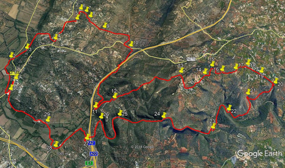
Walk Fifty One. Paderne Gorge. 21.6 kilometres. Ascent: 620 metres
GPS: 37/ 10`33. 18 8/ 12`14. 44
This is a long walk, but not especially strenuous. It takes in a variety of terrain, including the spectacular Quarteira River Gorge, which is met towards the end of the walk. When the river is running, three crossings are necessary, and after prolonged heavy rain this should not be attempted. There is a fourth water hazard near the end of the walk, involving the wading of an extensive ford. Again, this becomes dangerous after heavy rain. During dry periods, these water courses dry up altogether, making an easier but less exciting transit. You are advised to take along alternative footwear for these water crossings. There are no refreshments at any point along this route, but there are two or three bars near the car park in Paderne for the start and finish. (see below).
Getting to Paderne.
From either the N125 or the A22 motorway, leave at the Albufeira exit (IC1/ N395) and go north on the IC1 to Tunes. Turn right here and follow the road over the hill to Paderne. Cross the river from Purgatorio into the town, and park in the municipal car park on the right past the cemetery. There is a good bar, called Moiras Encantadas, just up the street on the left.
From the N124. Eastwards, drive around Messines on the main road. Pass the IC1 junction and the A2 motorway approach. Climb the hill under the motorway and past a filling station. At the small roundabout a few hyndred metres along, turn right. This will take you to Paderne. Westwards,coming from Alte, reach the roundabout after Messines de Baixo, on a short descent, and turn left.
The Walk.
- From the car park, (1) turn left into the main road and follow it past the cemetery and round the first bend opposite a large open space. Come to the bridge over a small stream, and turn right onto a clear dirt pathway that runs beside the water. Follow this track for around 850m to reach a tarmac road. (2). Turn right and come to a junction after a few metres. Turn right, and almost immediately see a track leading off on the left, uphill, heading roughly south-east. Climb the hill for about 300m to reach a junction (3) – see the remains of a circular threshing floor just ahead off the track. Bear left here and walk along for another 450m, descending at the end to a junction. Another large circular structure (an old fishpond) can be seen through trees on the left. Turn right here and climb steadily, passing a building on the left.
- The path curves to the right after 300m, and continues, to emerge into a tarmac road in a small settlement. Follow the road uphill to a junction with another tarmac surface after a short distance. (4). Turn left here and follow the road for just over 500m to a crossroads. Turn right and walk for a further 200m into another small settlement. Walk past a junction on the right and then immediately look for a turning on the left to the side of a house. (5) This looks like a small yard, but walk to the bottom left hand corner, and see the start of a path. This leads downhill beside a wall for about 250m to reach another tarmac road and the start of another settlement. Walk straight ahead past the first house, and turn right into a lane beside it. (6). Walk up the lane, and where it turns left after c160m, (7) continue heading roughly south on a less obvious footpath. After a further 200m, emerge onto a tarmac road by a house. (8)
- Turn right here and walk for about 100m to find a track on the left, between low walls. Head down this for around 300m due south, before crossing over the now broken wall on the left, (9) to follow a less distinct path a little more to the east of south. After a further c550m, come to a tarmac road shortly after passing a low building on the left. Turn right here and soon come to a junction with a main road. Turn left and walk for about 170m towards the motorway ahead. Where the road bears left, stay straight on (10) into a narrower tarmac road that heads for the motorway before turning to run alongside it. When the tarmac road turns sharp right after around 430m, go straight on into a dirt track. This soon descends and turns to run under the motorway. Turn right with the track on the other side, and walk for around 1.2k to reach a junction with a track coming downhill from the left. (11).Turn sharply to walk up this track, signed to ´Castelo´. After 350m, come to a hairpin bend to the right, but take the track going straight ahead. Walk round a right-hand curve, ignoring one turning to the left, but taking the second one, heading roughly north-west, after 130m (12).
- Now follow this track which rises over open country for just over 1.5k. It eventually reaches a tarmac road, with another track coming to meet it from the right, and a garden-/parking area between the two.(13) Turn right and walk uphill, passing a holiday villa complex on the right. The road bends to the left – follow it as it rises gently, passing more villas on the right. Then two large villas are passed on the hill to the left, the second with a large garden built up with stone terracing. After this second villa, the road becomes a track and begins to descend. Soon come to a hairpin bend to the right. Now take the track leading off the bend, heading south-east. (14). Descend for around 130m, to a junction with a house on the right. Turn left here and walk for another 100m+ to the end of a tarmac road. Pass one house and come to a hairpin turn to the right, (15) heading towards a house with two cypress trees guarding the gate.
- Opposite the gate find a track heading downhill. After 100m it turns right and then left after the next 100m. It finally descends to a junction with a track in the valley after a further 140m. (16). Turn left here and walk for 100m to finda narrow footpath coming down from the left. Turn sharply into this track and head steeply uphill. After around 270m, as the slope eases, come to a junction with another track and turn left (17). Another 230m brings you to a tarmac surface next to a house. Swing round the house (18) and follow the road downhill, heading due south, for just over 300m. When the road bends away to the left, take the footpath going straight downhill, to the right of a wall. (19). After almost 400m, swing sharp right onto a wide dirt track (20). This track undulates around the hill for around 750m to reach a junction with another track coming down from the right (21). Turn left into this track and follow it down to the river, around 830m away. It first descends steeply, then swings right, ending with a short walk on level ground to reach the first of three crossing points. (22).
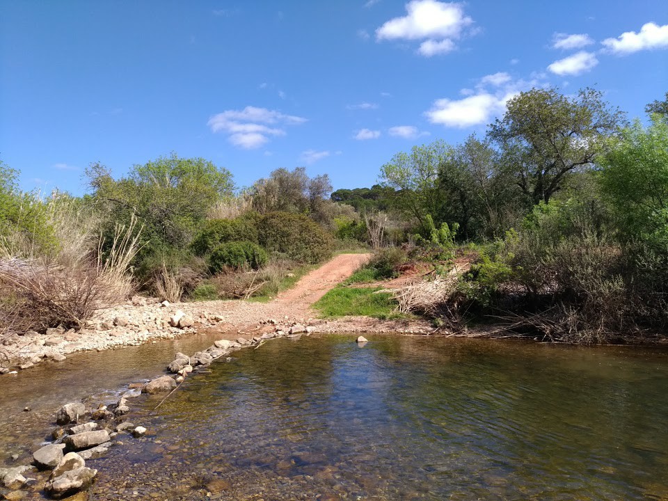
The Quarteira River, near point 22.
- Now, depending on the season and the rainfall, walk, paddle or wade across, to find a footpath on the far bank – turn right along it. The path wanders away from the river but returns to it after around 800m, where you must cross again. Do NOT take any paths, even obvious ones, leading away from the river valley. (23) From there, the path rises a little before coming back to the valley and continues to follow the river for a further 1.3k before reaching the third crossing. (24). Reaching the bank for the final time, find a short section of side channel (not often wet) to walk through to reach the footpath once more. The first section of this part of the river path is a little obstructed by overhanging creepers, but it soon clears, and a walk of around 950m will bring you to the Roman Bridge. (real origins disputed).(25)
. - Stay on the same side of the river and follow the footpath round further bends for a little over 800m. Walk on past the old mill and see the weir on your right. Walk past the first turn to the left after the mill, and follow the path indicated by stones. Turn left with the path, steeply uphil(26), following the track to pass under a rather sinister looking metal gate-frame before reaching two houses on the right after which the surface turns to tarmac and you then cross the motorway. 100m on from the far end of the motorway bridge find a track on the right leading off across open ground. (27). Follow this winding track for around 350m, at which point it becomes a more obvious dirt road and swings left to pass by a farm. From here walk for around 540m to a junction with a road on the right (28). Turn here and negotiate the water crossing as you please – for much of the year it will be dry, but you should be prepared to paddle or wade again! Now follow the road up to a junction with another broad track coming in from the right. (29) Bear left and reach a tarmac road after a short distance. Turn left here and simply walk along the road to reach Paderne at a point opposite where you turned onto the river path at the start. (30) Turn right to walk into the village and the car park.
GPS Points. 37/8
| 1 | Car Park | 10 | 33 | 18 | 12 | 14 | 44 | ||||
| 2 | Tarmac road | 10 | 46 | 56 | 12 | 01 | 32 | 1.22k | |||
| 3 | Threshing floor | 10 | 39 | 07 | 11 | 48 | 32 | 540m | |||
| 4 | Junction | 10 | 26 | 05 | 11 | 28 | 53 | 1.20k | |||
| 5 | Left turn | 10 | 21 | 67 | 11 | 03 | 35 | 740m | |||
| 6 | Right turn | 10 | 24 | 17 | 10 | 53 | 15 | 270m | |||
| 7 | Leave track | 10 | 19 | 26 | 10 | 52 | 91 | 150m | |||
| 8 | Tarmac by house | 10 | 13 | 90 | 10 | 55 | 91 | 210m | |||
| 9 | Move left | 10 | 02 | 02 | 10 | 56 | 97 | 410m | |||
| 10 | Leave main road | 09 | 39 | 32 | 10 | 59 | 05 | 980m | |||
| 11 | Hairpin turn | 09 | 36 | 46 | 11 | 59 | 92 | 1.77k | |||
| 12 | Left on track | 09 | 28 | 91 | 11 | 45 | 29 | 480m | |||
| 13 | Tarmac road | 08 | 59 | 98 | 11 | 00 | 05 | 1.56k | |||
| 14 | Hairpin | 08 | 46 | 37 | 10 | 51 | 54 | 810m | |||
| 15 | Hairpin by houses | 08 | 44 | 57 | 10 | 41 | 27 | 300m | |||
| 16 | Track junction | 08 | 37 | 27 | 10 | 39 | 33 | 330m | |||
| 17 | Veer left | 08 | 30 | 48 | 10 | 34 | 05 | 310m | |||
| 18 | On tarmac | 08 | 25 | 10 | 10 | 25 | 85 | 300m | |||
| 19 | Path by wall | 08 | 15 | 03 | 10 | 25 | 53 | 320m | |||
| 20 | Right turn | 08 | 03 | 32 | 10 | 26 | 11 | 360m | |||
| 21 | Track junction | 08 | 15 | 62 | 10 | 46 | 33 | 760m | |||
| 22 | Crossing 1 | 08 | 20 | 97 | 11 | 04 | 68 | 840m | |||
| 23 | Crossing 2 | 08 | 24 | 63 | 11 | 24 | 82 | 820m | |||
| 24 | Crossing 3 | 08 | 55 | 13 | 11 | 38 | 07 | 1.27k | |||
| 25 | Roman Bridge | 09 | 20 | 20 | 11 | 54 | 94 | 920m | |||
| 26 | Turn uphill | 09 | 29 | 28 | 12 | 04 | 51 | 1k | |||
| 27 | Turn off tarmac | 09 | 29 | 07 | 12 | 24 | 48 | 560m | |||
| 28 | Water crossing | 09 | 43 | 63 | 12 | 41 | 79 | 1k | |||
| 29 | Road junction | 09 | 57 | 47 | 12 | 29 | 35 | 610m | |||
| 30 | Paderne | 10 | 31 | 41 | 12 | 24 | 11 | 1.21k | |||
| End | 200m |
Note that left is broadly north in this case.