Walk Seventy Three. Soalheira Circular. 17k 400m of ascent.
GPS: 37/09 25 70 ; 08/ 04 50 63
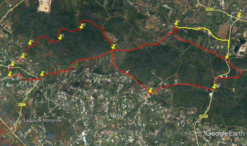
Soalheira is one of a series of hillside villages to the west of Loulé, off the main N270 road between Loulé and Boliqueime. This walk, a figure-of-eight, covers a large area of uninhabited land between Soalheira and the Loulé-Salir road near Tor. Mostly on wide clear tracks, there are two short sections which are slightly overgrown, and a couple of stretches of tarmac. The most testing bit comes right at the end, with a steep climb up to the finish. There are refreshments near the mid-point, with only a short detour or route change to access.
NOTE: Since this walk was devised, the section leading to Val Telheiro (1.7k) has been tarmaced, so if you have an aversion to road walking, this may not be for you.
Getting to Soalheira
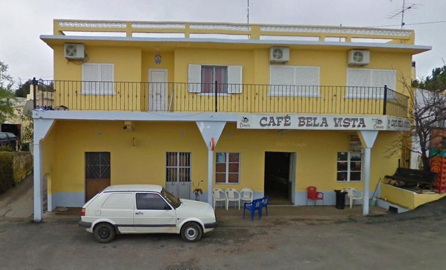
From the west. Come off the A22 at the Boliqueime exit, and follow signs to Loulé. Go up the hill past the quarry and take the first left as the road tends downhill. At the T junction in Parragil turn left and then right at the crossroads soon after. Follow this road for 1.7k to reach a very large villa with black wrought-iron gates and railings on the right. Turn right here and find the café Bela Vista on the right at the next junction.
From the east and south. Come off the motorway at Loulé Centro, or come along the N270 from Sao Bras, and follow signs to Boliqueime. Turn off the bypass at the Boliqueime roundabout and look for the road signed to Soalheira on the right after around 2.8k. Drive up this road for 1.5k, to a sharp left hand bend with post boxes and a sign to Sobradinho on the right. Fork LEFT as you go round this bend and follow the road for around 800 metres to the crossroads with the café Bela Vista opposite.
The Walk
- With your back to the Cafe, (1) turn left and walk up the road signed to Varejota and Parragil. Go over the rise and down to a T-junction, turning right. About 100m along turn left on a narrow track towards buldings. (2) Take the first right into a narrower lane that leads between buildings, then passes a building on the right before running between fields to reach another building on the right, and finally ending at a tarmac road. Turn left. (If desired, you can avoid this lane by going straight on at Point 2 and turning left at the next junction.
- Turn right at the next junction, and left at the following one (3). Now follow this road round a right-hand curve and then go straight ahead onto a dirt-track, heading more or less due north. Some 400m from point 3, come to a fork and take the right hand. (4). Follow this track, descending gently and then on level ground,passing a turn to the right after 250m and one to the left a further 330m along. 470m further still, come to a sharp left-hand bend (5)
- Continue along the winding track, still descending, for a further 900m to a second sharp left turn. (6) (There is a plantation just over to the left here, but you cannot see it from the lane). After the bend, the track goes west of north for a while and then turns due east. Ignore minor turns to the left and come to a rather wider one, around 870m from point 6. Go past this and very soon turn south-eastwards, descending more steeply to reach a cross-tracks after another 670m. (7)
- Turn left here and follow the track for 2k northeasterly, down to a T-junction with a wider dirt road coming in from the left. (8) (ignore a turn to the left after 600m on this section). Here there is a choice to be made. If you wish to visit the mid-walk Bar for refreshments, (yellow line on the photo) turn right and walk along the wide track to its junction with a main tarmac road - about 1.5k. Turn right here and walk a short distance to the Bar Varzea. Then you will need to walk up the hill to rejoin the main route at Point 9. If the Bar is not your choice, turn right and then almost immediately find a somewhat overgrown double track leading off right, just east of south.
- Follow this until it runs out at a broken-down field wall. (340m). Go over and find a narrow rocky footpath heading due east, climbing gently to meet a wider dirt track after another 540m Turn left along this new track for another 870m due east to reach a tarmac surface. Turn right and quickly come to a three-lane main road. (9). Cross over with great care and take a narrower tarmac road on the other side, heading initially just south of east. Follow this as it starts to climb quite steeply, describing a wide semi-circle of around 1.2k to arrive back at the main road on level ground. (There are two turns to the left to avoid on this climb).
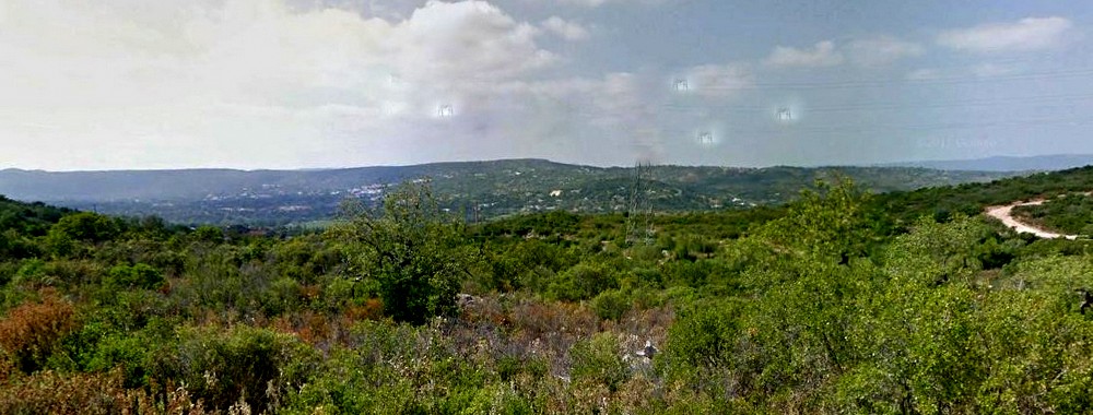
Looking north towards Tor.
- Turn left along the road and take the first on the right - a tarmac road, but very quiet - signed to Vale Telheiro. (10) Walk along this road for about 1.7k as it gradually turns south-westwards and arrives at a junction with a tarmac surface to the left and a large villa facing you. (11). Turn right here along a dirt road and follow it for 1.6k, ignoring a turn to the left after c700m. The track descends to a cross-tracks, and you have returned to Point 7.
- Turn left here and walk for 2.1k south-westerly to reach a tarmac road on a steep hill. (12) Turn right up the hill and very soon reach a junction. Cross over and take the narrower road opposite, slightly uphill and curving round to the left. (Not the road with the bus stop - the other one!). Now simply follow this road as it climbs steeply back up to Soalheira and the start of the walk - around 830m.
| 1 | Soalheira | 09 | 25 | 55 | 04 | 50 | 48 | ||||
| 2 | Turn to lane | 09 | 34 | 33 | 04 | 52 | 08 | 330m | |||
| 3 | Dirt track | 09 | 43 | 60 | 04 | 45 | 56 | 410m | |||
| 4 | Fork | 09 | 56 | 26 | 04 | 44 | 22 | 410m | |||
| 5 | Left turn 1 | 10 | 10 | 19 | 04 | 17 | 32 | 1k | |||
| 6 | Left turn 2 | 10 | 25 | 67 | 04 | 01 | 58 | 900m | |||
| 7 | Cross tracks | 10 | 20 | 57 | 03 | 22 | 52 | 1.5k | |||
| 8 | T Junction | 11 | 00 | 90 | 02 | 30 | 64 | 2k | |||
| 9 | Main road | 10 | 51 | 04 | 01 | 27 | 14 | 1.8k | |||
| 10 | Val Telheiro turn | 10 | 22 | 81 | 01 | 29 | 05 | 1.55k | |||
| 11 | Val Telheiro | 09 | 58 | 90 | 02 | 28 | 91 | 1.7k | |||
| 7 | Cross tracks | 10 | 20 | 57 | 03 | 22 | 52 | 1.6k | |||
| 12 | Tarmac on hill | 09 | 36 | 06 | 04 | 20 | 38 | 2.1k | |||
| End | 830m |