Walk Seventy Four. Val Luis Neto Double circuit. 20 kilometres. Ascent: 700 metres
GPS: 37/ 15 17 28 7/ 55 04 45
This is a walk that can be completed as a whole or divided into two, as it consists of two circuits with a common linking section. Starting from the N124 a short drive out from Barranco do Velho towards Cachopo, it descends into a valley, then up to two small settlements on the hill above, then out into open country, using the linking section to reach the hamlet of Val Luis Neto. The second circuit moves on from there further into the wilds, passing two more hamlets before returning to Val Luis Neto. After repeating the link, the final part involves a long descent into a valley and a climb back out to the start. A varied walk with a couple of challenges, Refreshments at Montes Novos, but a bit close to the start for a long break.
Getting to Barranco do Velho and the start.
One of the easier starting points to find. From the south take the Faro/ São Brás de Alportel exit from the A22 motorway, and travel north along the N2 up to São Brás. Use the town bypass to resume the trip north up the N2 to Barranco do Velho. Come at last to a junction with a turn left to Loulé/ Salir. Go straight on here, over two large road humps and up the hill. Find a café (Tia Bia – actually a pensão/restaurant, they have rooms) on the right at a junction turning right to Cachopo. Coming from the west, take the N124 from any point from Silves eastwards, and stay on that road to Barranco. Turn left at the junction with the Faro road (N2) to reach the café. Get your caffeine fix here if needed, and then take the Cachopo road, driving for just under 3k. Your parking area is on the left, just a small open area with a track leading off it, immediately before a short cutting on the main road between a shale outcrop. Try not to block the track with your car.
The Walk
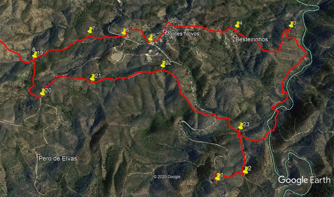
- From (1), walk down the road through the small cutting and take the first track on the right after 100m, descending quite steeply into a valley. At the bottom after 300m, turn left and walk along close to the watercourse on your right. Coming to a junction after a further 430m, go round in a hairpin right, curve gently to the left, climbing, on this new track. Drop down into a dip and cross a stream, climbing briefly again and taking the first turn to the left. (510m) (2) Ignore minor tracks descending on the right, go round left and right hand bends and stay right as a track leads off steeply uphill left after 330m. After a further 170m come to a fork and take the right hand uphill north-eastwards with trees below. The track turns more due east and descends for a while. After 600m swing round in a wide curve to the left and climb again due north to reach a junction after 390m, taking the left-hand hairpin to carry on climbing out of the valley.(3)
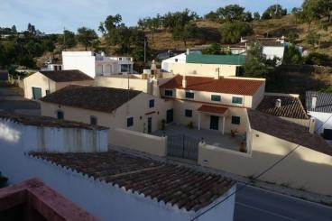
- Now walk first more or less westerly over 360m, veering more north-west to reach a fork after a further 170, going right to walk due north for a further 400m, arriving at a bend at the beginning of a concrete road, with a small washing-place on the corner. (4) These communal clothes washing facilities were in full use by most villages until very recently. The settlement that it served, Bestinheiros, is over on your left. Walk up past it on the concrete and come to a tarmac road after 140m, turning right. Veer right at a junction after less than 100m and follow through a section of open land, coming to the outskirts of a larger village, Montes Novos, around 440m along.
Montes Novos.
Follow the main road past a row of buildings down to a wide curve to the left (200m) (5) Immediately round the bend turn right and walk for 200m. Stay right at the next two junctions and emerge onto a main road (the N124) after a further 330m. Turn right along the road for 100m and having passed a house on the right, take a track going off to the left northeastwards through trees, opposite the Montes Novos boundary sign. (6) After 140m, halfway round a right hand curve, take a track on the left which quickly turns right under trees. Pass a minor junction of tracks and come to a clear junction after 200m with four alternatives in front of you. (7) Take the first left starting due west and follow this track (can be a bit wet after rain) as it heads north of west over open land and comes to a junction with a stony track leading off to the left after 620m (8). This is the track you will take on your return leg, point 19. If you wish only to do the first circuit, you can turn left here, following the instructions from that point.
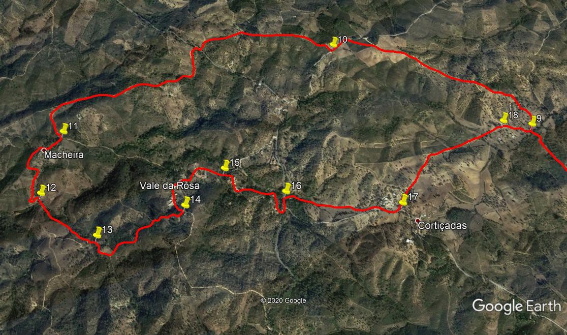
- To continue, now along the linking section between the two circuits, go straight on, round a right hand bend and due north over an area of open land. As you start to descend on the other side of the small plateau, see the hamlet of Val Luis Neto ahead. Go down to the stream or dry bed in the valley, cross it and veer left up the track. At the first junction turn right. (9) (1k from 8). Walk along for 160m, then turn left uphill towards the ruins at the eastern end of the village. Walk between the ruin foundation to pick up a track leding out of the settlement. At a junction after 190m stay left and walk for a further 270m north-westerly past scattered houses to another junction. Continue northwest along a sandy track for another 800m, to reach a tarmac road. Turn left and walk along for 270m round a shallow left-hand curve to find a track on the right leading uphill almost due north (10).
- Take this track as it quickly turns northwesterly and eventually almost due west, to descend to another tarmac road after 1k. Turn right and immediately left to leave the road on a wide track. This crosses more open land and then descends quite steeply down into a valley, curving right at the bottom to go up a short rise to a group of buildings after 1.57k. This is the hamlet of Macheira. (11)
- At the top of the rise turn right.. Find a farm track passing in front of buildings and follow it as it turns to head off south south east and follow it as it turns due south, winding downhill through trees,, to reach a stream crossing after c380m. (12) Cross and head south east for 460m. At a point where the track starts to turn sharply to the right, turn off left and cut across the valley bottom to reach a rough track on the other side (13) This may be rather overgrown, so take care..
- Head first southeast, then tend a little north of east, climbing quite steeply, and finally just south of east on more or less level ground to come to a junction with a wider track after 700m. (14) Turn left to walk due north for 180m through the village of Vale da Rosa. Follow the road round to the right, through a left hand curve and then quite sharp right again, then descending on a straight line for 150m to find a narrow road leading off uphill on the right. (15). Walk up here. After 180m keep left at a junction, and follow as the road climbs for a further 380m to reach a main road.
- Turn left and then first right after 100m (16) to walk down a minor road for less than 100m. Past the first row of buildings, after a dilapidated open shed, turn right along a footpath heading south-east under trees. After 170m the path kinks left and then right to enter more open country and eventually ends at a tarmac road after a further 290m. Turn left. Go past one turn to the left, leading to a farm, and take the second one, a sandy track going uphill after 260m. (17) The track rises gently and then descends equally gently across open land and comes to buildings after 970m – you are back at Vale Luis Neto, having closed the second circuit. Avoid the first turns on the right, to buildings, and take the next one (18), which will lead you down to the stream you crossed earlier, (220m) and back onto the linking track. Climb the short steepish hill onto the plateau and cross it due south (1k). When the track bends sharply to the left, look for the turning on the right - point (8/19) – and take this path to begin the completion of the first circuit.
- Head along this path south-west then due south until you come to a tarmac road after 530m. (20) Turn left and walk up the short rise. Past a track on the left at the crest, find a track forking off to the right after 300m and walk along it south-eastwards. Take the left hand at a fork after 320m (21) and then ignore turns to left and right, heading steadily southeast down a ridge line. When the descent becomes steeper, look for a turn to the right at a fork after 730m (22) and continue to descend on the ridge, now heading south. Arrive at a tarmac road after 760m and go straight across, continuing southwards. Coming to a stream after 330m, (23) you have now closed the first circuit. Take the path to the right uphill, rounding the bend to the right after 430 to return to the road and your car. (830m)
There are two photos for this walk, showing the two circuits.
Left is northwest. 37/ 7
GPS Points.
| 1 | Start on N124 | 15 | 17 | 28 | 55 | 04 | 45 | ||||
| 2 | Left turn | 15 | 13 | 38 | 54 | 30 | 70 | 1.34k | |||
| 3 | Turn to Bestinheiros | 15 | 30 | 58 | 53 | 51 | 65 | 1.49k | |||
| 4 | At Bestinheiros | 15 | 44 | 37 | 54 | 08 | 58 | 930m | |||
| 5 | Montes Novos | 16 | 03 | 40 | 54 | 26 | 98 | 1.13k | |||
| 6 | Turn off main road | 16 | 12 | 51 | 54 | 45 | 89 | 870m | |||
| 7 | Multi junction | 16 | 19 | 69 | 54 | 54 | 61 | 340m | |||
| 8 | And 19. Start of link | 16 | 26 | 18 | 55 | 17 | 84 | 620m | |||
| 9 | End of link (Vale Luis Neto) | 16 | 56 | 95 | 55 | 26 | 02 | 1k | |||
| 10 | Turn off tarmac | 17 | 28 | 68 | 56 | 01 | 11 | 1.69k | |||
| 11 | At Macheira | 17 | 32 | 24 | 57 | 20 | 74 | 2.57k | |||
| 12 | Stream crossing | 17 | 20 | 14 | 57 | 19 | 75 | 420m | |||
| 13 | T Junction | 17 | 05 | 76 | 57 | 14 | 88 | 520m | |||
| 14 | Before Vale da Rosa | 17 | 07 | 53 | 56 | 56 | 12 | 540m | |||
| 15 | Leave main road | 17 | 12 | 26 | 56 | 42 | 27 | 550m | |||
| 16 | Turn to footpath | 17 | 02 | 25 | 56 | 29 | 74 | 560m | |||
| 17 | Turn to Vale Luis Neto | 16 | 50 | 92 | 56 | 05 | 01 | 720m | |||
| 18 | Vale Luis Neto | 16 | 58 | 55 | 55 | 29 | 07 | 970m | |||
| 19 | And 8, end of link | 16 | 26 | 18 | 55 | 17 | 84 | 1k | |||
| 20 | Main road | 16 | 13 | 78 | 55 | 26 | 27 | 530m | |||
| 21 | Fork on ridge | 16 | 06 | 07 | 55 | 08 | 82 | 320m | |||
| 22 | Fork on descent | 15 | 52 | 99 | 54 | 45 | 17 | 730m | |||
| 23 | Close of circuit one | 15 | 21 | 38 | 54 | 43 | 10 | 1.09k | |||
| End | 830m |