
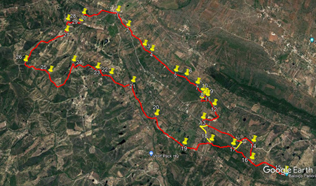
Walk Sixty Eight. Santa Margarida Circular. 17.7k Ascent: 652m
GPS: 37/ 14 46 05 8/ 11 21 11
Getting to Santa Margarida.
The Walk.
With your back to your car, turn left and walk back to the centre of Santa Margarida.. The official start-point is at the crossroads, with a bar opposite.(1) Go straight across, leaving the bar on your left, and enter the Estrada das Eiras. Emerge on level ground overlooking a valley on the right, with a number of barragems.(dams). Into open country, pass a large pale yellow house on the left with an Estrada sign on the wall, and after 20m turn left on a gravel track. (2) After 30m, turn right uphill with the gravel towards a converted windmill ahead. Bear right past the mill and follow a rather overgrown dirt track up left and then right, to head gently uphill north-west.
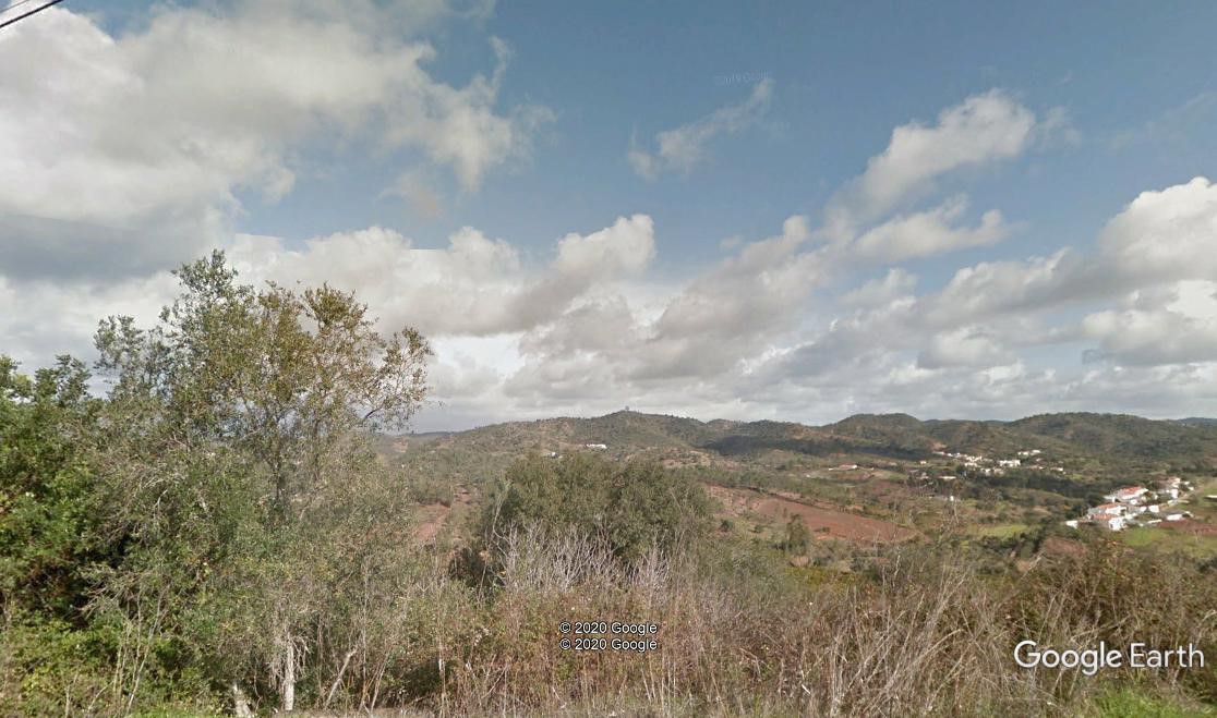
View near the start, looking over to Picota, the highest point.
Follow the track for around 480m from the gate to the windmill, at which point it ends. (3) You are now surroundeed by scrubland, with many alternative ways forward, so follow the next instructions carefully. A reasonable guide as to whether you are following a recognised path is to look for where other boots have discoloured the rocks, leaving an orange-brown stain. Go forward from the end of the track for a short distance on a patch of open ground, and where that ends facing low bushes, turn left. After around 20m, turn right on a narrow fottpath, heading just north of west, and follow it for something over 100m to the first landmark, the corner of a low wall. (4)
Pass to the left of the wall, and continue on the same heading, keeping fairly close to the edge of the plateau, for another 400m, winding through rocks and low scrub. As you go, see the first glimpse of three wind turbines ahead, and to the left through a gap, the town of Messines in the valley. At the end of this section, come to a house over on the right, with a garden between you and it. Pass the house by way of a gravel area with a picnic table, and follow the path as it dips into a shallow depression on the other side. For the first 300m or so after the house, the path is pretty clear, but very winding. At this point (5), the path turns slightly south of west for about 250m, to point (6), and then resumes a more northwesterly line. On this section, you will find that the path sometimes seems to disappear in front of small trees or bushes. Work round both sides to find where it resumes.
Continue to follow the path quite close to the edge of the plateau for another 300m, to point (7). Keep on passing by or over the remnants of stone walls, a reminder that the whole of this large area was once clearly divided and cultivated. Small concrete markers indicate where land ownership is maintained. From point 7, the path keeps roughly to the northwesterly line, but the edge of the plateau moves further away on the left. After another 180m, come to point 8, and turn slightly to the right with the path, which becomes steadily more rocky, but you will see and sense that you are coming towards the end of the plateau. Another 16m brings you to that point, (9) where you can stand and look out over the valley, with the motorway and Messines in the foreground, and away in the far distance, the Serra de Monchique, the highest hillis in the region.To continue the walk, and to descend from the plateau, retrace your steps for around 60m, and find a path similar to the one you have been following, heading over to the left. (10). Follow this is it descends over rocks and through bushes, ending after around 120m at a wide gravel track. (11)
Turn left along the track, and after around 350m on a right hand curve as the track starts to descend, find a track on the right going downhill quite steeply.Follow this down for 200m, coming to an open space where the track turns sharp left. (12) Look over to the right here, and see a wall of rocks and a tree line ahead. Walk right for a few paces, then turn left and find your way over the rocks at a gap in the trees, and drop down onto a track, with a tree plantation in front. Turn left and walk around the plantation for around 220m. At a sharp right hand corner, look left to see another track slightly below the one you are on, and drop down under trees to reach it.Turn right and follow the track for about 350 as it rises, eventually coming to a junction with a tarmac road. (13) Turn left. At this point there is the opportunity to shorten the walk. After 130m, turn right on a track. Following this will bring you after 550m to Point 18 Turn right here to continue the route. To continue the full walk, continue along the road for a further 700m, to the hamlet of Pico Alto.
Here is another choice, to cut out some distance and ascent. Instead of staying on the main road, take the lane on the right leading up into Pico Alto. A few metres along, turn sharp right up a narrow land which leads after 170m to a building which used to be the local school, and is now a small environmental research centre. You are now close to point 17.
To continue the full walk, stay on the road as it rounds the hamlet and starts to descend. 320m from the second short-cut, see a track on the right, ascending quite steeply. (14) Follow this as it climbs towards the first of the three wind turbines. When you reach the first one, there is yet another chance to take off some distance, and a void a backtrack. Off the bend on the right by the turbine, find a narrow path leading off sharply to the right. Follow this for just over 400m to reach the old school, and follow instructions from there.
Those still determined to do the whole route should carry on past the other two turbines. After the third one, the wide track becomes a rocky footpath. At a track divide, bear right and soon come to the end of the ridge, with a trig pillar and an excellent view, with a lookout tower and a swing!.(15) A good place for refrreshment. To continue, you must retrace your steps to the first turbine. At the bend by it, find the narrow path on the left (16) which will lead you after 400m to the old school.
Cross the hard surface of the school yard and go over the low wall at the other side. Walk through the field beyond, keeping to the left, and find the beginning of a path leading down on the left. (17). Follow this for almost 500m as it descends, sometimes steeply. Come to a wide dirt track and turnright. After about 100m, come to a wide dirst road, and turn left (18).
Follow ithe track down to meet a tarmac road after 350m.. Turn right here, and walk along it for just over 1k, taking the right at a fork after 280m,(19) and then passing through the small settlement of Conqueiros. Beyond the settlement pass another small group of houses off to the left. Soon after, see a small barragem on the left, and take the next track on the left, going downhill. (20). At the bottom turn right, and walk along a track just above the valley floor. After 1k, the track turns sharp left to cross the valley floor. (21) It then kinks right and left, with a house over to the right, and comes up to another tarmac road. Turn right, and after 150m, bear left on a narrow dirt track leading gently uphill. (22) After 280m, come to a track junction and turn right. Walk on level ground for 130m to reach a wider tarmac road, and turn left.
Take the second turn on the right after a short distance. (23). Wind uphill through trees and emerge onto open country, passing a rather dilapidated farm on the right. Go through a dip and up to a junction, with a house up to the left. (670m from the road) (24). Walk up past the house and climb steeply, due north. The track swings round to face more south-east eventually, but continues to climb. After 960m, arrive at another trig pillar.(25). Now start to descend, very steeply at one point, over 650m, along a ridge. Pass two or three tracks heading downhill on the right, and come to quite a wide track heading due south on a ridge.(26). Walk down for something over 900m, to reach the houses of the village of Macheira. Walk down through the settlement, leaving it behind, and after 300 m, come to a junction with another tarmac road. (27) Go straight ahead for a few metres, and at a junction turn left. Again after a few metres turn right along a rough track heading due south, Drop down into a stream bed and climb up the other side. After 200m, turn right (28) and walk round the right hand edge of a barragem. The path continues from the barragem. Fork left soon after leaving it, and climb to reach quite a wide dirt road after just over 100m.
Turn right, and after 100m, immediately beyond the first house on the left, turn left down a rough track towards a shallow valley. (29) Wind through trees to reach another barragem. Pass to the left of it, past a small stone building, (30)and follow a now more obvious track as it climbs over 450m up to a tarmac road. Turn right here, to walk back into Santa Margarida, 350m away.
Orientation normal. GPS 37/8
GPS Points.
| 1 | Sta. Margarida X roads | 14 | 50 | 16 | 11 | 24 | 22 | |||
| 2 | Turn left | 14 | 37 | 65 | 11 | 39 | 25 | 430m | ||
| 3 | End of track - forward | 15 | 06 | 84 | 12 | 01 | 00 | 670m | ||
| 4 | Wall corner | 15 | 08 | 26 | 12 | 08 | 93 | 200m | ||
| 5 | Straight on | 15 | 14 | 86 | 12 | 35 | 04 | 710m | ||
| 6 | Veer right | 15 | 14 | 40 | 12 | 44 | 42 | 230m | ||
| 7 | Pathgoes right | 15 | 16 | 80 | 12 | 55 | 60 | 300m | ||
| 8 | Bear right | 15 | 19 | 66 | 13 | 01 | 85 | 180m | ||
| 9 | End of plateau | 15 | 21 | 48 | 13 | 07 | 12 | 150m | ||
| 10 | Turn left | 15 | 20 | 83 | 13 | 04 | 70 | 100m | ||
| 11 | Turn left | 15 | 24 | 51 | 13 | 03 | 74 | 120m | ||
| 12 | Bear right | 15 | 25 | 12 | 13 | 15 | 23 | 350m | ||
| 13 | Turn left | 15 | 36 | 62 | 13 | 11 | 25 | 600 | ||
| 14 | Turn right | 15 | 36 | 60 | 13 | 54 | 54 | 1.16k | ||
| 15 | Trig point | 15 | 46 | 41 | 14 | 24 | 44 |
1.12 |
||
| 16 | Bear left off track | 15 | 47 | 30 | 13 | 57 | 74 | 730m | ||
| 17 | Bear left downhill | 15 | 44 | 08 | 13 | 40 | 62 | 460m | ||
| 18 | Turn left | 15 | 47 | 15 | 13 | 24 | 15 | 460m | ||
| 19 | Fork right | 15 | 56 | 12 | 13 | 05 | 83 | 630m | ||
| 20 | Turn left | 15 | 46 | 65 | 12 | 35 | 40 | 900m | ||
| 21 | Left with track | 15 | 32 | 63 | 12 | 05 | 33 | 1k | ||
| 22 | Left into woods | 15 | 33 | 73 | 11 | 45 | 32 | 560m | ||
| 23 | Turn right | 15 | 34 | 27 | 11 | 32 | 33 | 370m | ||
| 24 | Sharp left | 15 | 36 | 86 | 11 | 11 | 44 | 630m | ||
| 25 | Trig point straight on | 15 | 50 | 49 | 11 | 00 | 13 | 970m | ||
| 26 | Turn right | 15 | 50 | 94 | 10 | 35 | 79 | 650m | ||
| 27 | Stay left | 15 | 18 | 66 | 10 | 51 | 15 | 1.2k | ||
| 28 | Turn right | 15 | 10 | 98 | 10 | 47 | 06 | 300m | ||
| 29 | Turn left | 15 | 07 | 61 | 10 | 58 | 32 | 250m | ||
| 30 | Right round building | 15 | 01 | 67 | 10 | 57 | 07 | 250m | ||
| END ( x-roads) | 850m |
.