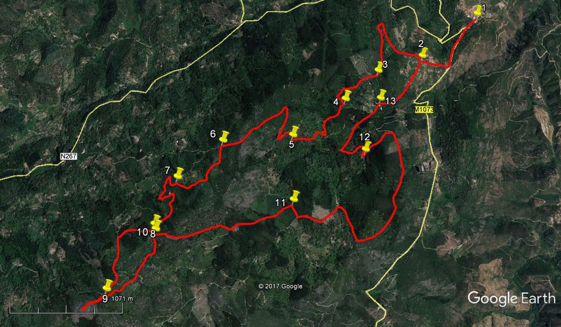
Walk Four. Alferce – Picota. 15.1k Ascent: 660m
GPS: 37/ 19 57 86 8/ 29 22 33
The Serra de Monchique is the highest land in the Algarve, and the small but significant massif is dominated by two summits, Foia and Picota. Foia is the higher of the two, but the summit is littered with buildings and communications masts. The views are excellent. Picota on the other hand is a cone of bare rock with a fire-watch tower and stunning 360 degree views. You pays your money…. This walk takes you from the village of Alferce on the eastern end of the Serra up to the summit of Picota. Alferce is quite a pleasant small settlement, but there is currently (2017) only one bar open, so it might be advisable to have pre-walk refreshment elsewhere – the place should be open on your return. I am indebted to Manuela and Theo Noordeloos from the Wednesday Walkers for this route.
Getting to Alferce.
From the south and west. Take the A22 to the Portimao – Monchique exit and turn towards Monchique. Go left at a roundabout, onto the N266. Pass a filling station on the left and look for a turn to the right signed to Larangeira and Alferce. At the next junction turn left, signed Alferce, and simply stay on this road all the way to the village. From south and east take the IC1 north from the A22 Albufeira junction up to Sao Marcos da Serra. There turn left onto the N267 to follow a winding and quite spectacular road through the hills to Alferce. Park on the right on the hill as you enter the village. The café is round the corner to the left.
The Walk.
- Starting from your car, (1) walk down the hill the way you drove in and fork left after c100m. Walk along this road for a further 420m to a junction, signed to Alto on the right. Go up the hill here for another 320m to a fork (2). Take the right-hand option and follow the road as it soon turns quite sharply left. At a point around 210m from the fork, where the road has narrowed and curves to the right, go straight ahead on a narrow track. It starts almost due west, then swings round to north-west, climbing, with houses down to the right. Ignore a turn to the left after 140m, and continue for a further 230m, passing a building on the left after around 200m.
- At this point follow the track around quite a tight curve to the left, still climbing, and after turning through 180 degrees, go ahead on the track, now facing due south and still climbing, for another 560m. Towards the end of this, the track veers slightly west of south, to arrive at a junction on the edge of the wood through which you have travelled. (3) Take the right-hand option here and walk for 460m south-west, to emerge onto a patch of open land facing the wall of a small dam or barragem up ahead, with power-lines passing over it. Turn left here and walk a further 110m to a junction with another track and turn right. (4) Walk through more woodland, still climbing, for another 190m, and curve round left as you emerge from the trees, with agricultural terracing on your right, and a house ahead. Bear left at the next junction to leave the house on your right, and walk south to another junction, descending a little now, passing another building on the right before getting there. (220m).
- Turn sharp right here, walking about 100m north-west, then the same south-west on level ground before turning more or less due west for a further 200m and climbing again to a right-hand hairpin bend (5). Climb a further 100m, turn left with the track and climb yet again for 100m to reach another junction. Turn left and at another junction 100m on, go round a hairpin right, to face east of north on a tarmac surface. Hold this line for 330m. Ignore a fork to the right just before the end of this distance, and almost immediately swing round another tight bend to the left, staying on the tarmac and heading south-west for 740m, still climbing steadily.
- Arrive at a point where a rough track crosses the road (6) and turn left, due south. After 100m, bear right and walk round an arc curving left for 230m, with houses visible in a valley to the right. The track then turns due west for a short time, then south of west, rising to a high point before turning more north of west and descending. Around 110m from the high point, with dwellings visible through trees on the right, turn left on a track (7) that starts off facing south-west but turns soon right to face due north, descending, arriving at a junction after 130m.
- Turn sharp left here and descend south-easterly for around 90m, then begin to climb again slowly, turning due south and then south-east again over another 110m. Ignore a turn to the right here and walk ahead to turn another sharp bend to the left very shortly. Now head north-east for 160m turning sharply right from there to walk almost due south over the next 240m, in two wide arcs to the left, climbing all the time. Ignore a turn to the right at a junction with a wider track, and continue south-west for a further 200m to find a turn to the right into a wood. (8).
- Walk through the wood, starting to descend a little, for 110m, then walk across open ground for the next 240m to a junction with a tarmac road. Turn left and walk along the road for 560m. (9) Go straight ahead at the junction to the end of the tarmac, and climb the rocky summit cone of Picota to the fire-tower. (220m).
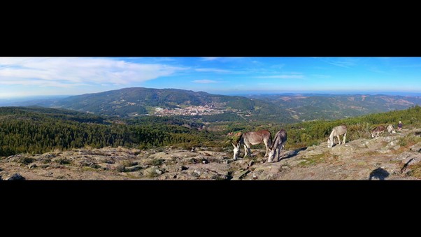
Monchique from Picota summit. (Photo by Lucy T)
- To return, go back to point 9 (220m) and fork right off the tarmac onto a track heading north-east. It kinks right and left after 120m, but then resumes north-easterly for another 470m before turning due north for a further 190m, arriving at a cross-tracks with a wood on the left. (10) (You are now only a few metres away from point 8 on the outward route.) Turn right here and follow this track for 730m as it soon turns just north of east, descending. At the point where the track curves sharply to the right, go left onto a track through woodland that continues the line north of east for a further 640m. Arrive at a junction with a tarmac road (11).
- Turn right and follow the tarmac for 2.25k. (you are unlikely to meet more than two or three vehicles, if any). Arrive at a turn to the left signed to Boavista and walk up the slope. After 380m turn right at a junction (12) (house just below at the start of the hill) and descend on a winding track over 390m. Curve round to the right to descend steadily over a further 630m to reach a junction. (13) Turn right and walk for another 660m to get back to point 2. Now turn right again to walk back into Alferce. (900m)
Orientation Normal. GPS 37/8
GPS Points:
| 1 | Alferce | 19 | 57 | 86 | 29 | 22 | 33 | ||||
| 2 | Fork | 19 | 43 | 51 | 29 | 45 | 72 | 900m | |||
| 3 | Fork after wood | 19 | 37 | 99 | 30 | 04 | 47 | 1.14k | |||
| 4 | Turn after barragem | 19 | 28 | 84 | 30 | 17 | 64 | 570m | |||
| 5 | Sharp Right | 19 | 17 | 34 | 30 | 38 | 45 | 810m | |||
| 6 | Turn near settlement | 19 | 15 | 43 | 31 | 05 | 18 | 1.33k | |||
| 7 | Turn after settlement | 19 | 04 | 39 | 31 | 22 | 24 | 680m | |||
| 8 | Right turn | 18 | 50 | 31 | 31 | 30 | 36 | 960m | |||
| 9 | Below Picota | 18 | 31 | 38 | 31 | 47 | 57 | 910m | |||
| 10 | Right by wood | 18 | 48 | 87 | 31 | 29 | 87 | 780m | |||
| 11 | Right after wood | 18 | 57 | 39 | 30 | 38 | 27 | 1.37k | |||
| 12 | Top of descent | 19 | 12 | 91 | 30 | 09 | 92 | 2.63k | |||
| 13 | Right turn to 2 | 19 | 29 | 47 | 30 | 03 | 19 | 1.02k | |||
| End | 1.56k |