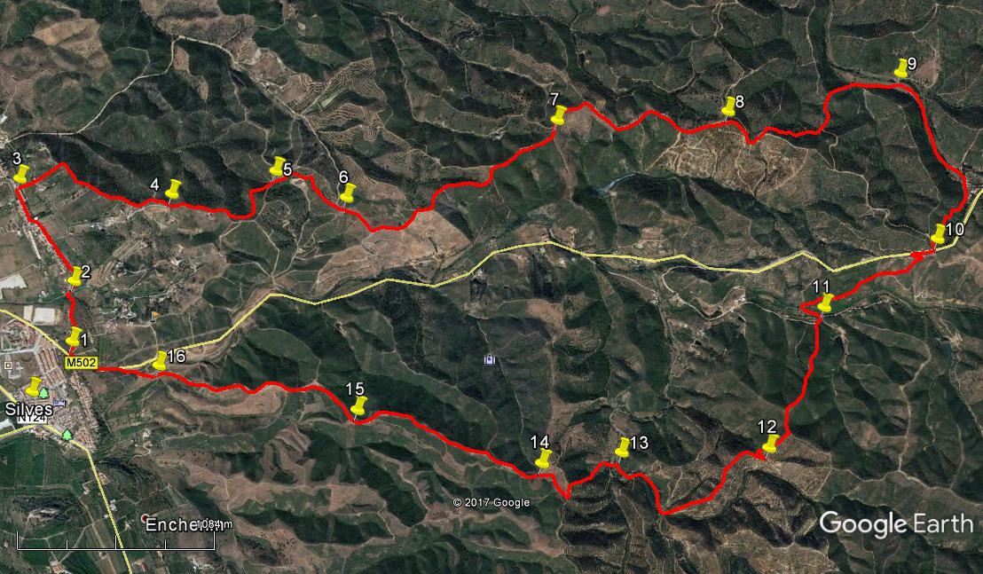
Walk Seventy Two. Silves – Val de Linhares. 15.5 kilometres. Ascent: 580 metres.
GPS: 37/ 11 56 55 8/ 25 59 83
The walk starts from the outskirts of Silves, the ancient capital of the Algarve, follows a levada for a short distance, and then runs north along a ridge to the tiny settlement of Val Linhares on the old road to São Marcos da Serra, before crossing the road and returning via valleys and hills on the other side. Good views and a variety of countryside.
Getting to Silves and the start.
From the west and south, take the Silves/ Lagoa exit from the A22 (or Silves from the N125 at Lagoa, and follow signs to Silves. Coming down the hill towards the town, see the castle above it, and turn left at the bottom of the hill. Turn right at the traffic lights across the bridge and drive to the first roundabout, which has a stone cross on it. (Cruz de Portugal). Take the third road off the roundabout – a slightly awkward traffic system – along a straight road by the town cemetery. Immediately after the cemetery, turn right and stay right as a road comes in from the left. Pass the buildings of the University on the right, and soon after come to the point where the road goes over the levada (irrigation canal), just before a fork in the road. Park where you can here.
From the east, access the N124 from the IC1 at Messines, or from further east, and drive along to Silves. Come to the Cruz de Portugal roundabout after passing a petrol station on the right, and take the second road right past the cemetery – then follow as above.
The Walk
- To start, go to the bridge over the levada and face away from the houses on the hill. (1) Now take the path on the left hand side of the canal and walk along it. (This is the levada that runs from a large reservoir (barragem) several kilometres away to the east, along the Arade valley, supplying irrigation to the orchards and vineyards in this very productive area.) After 320m, come to the beginning of an aqueduct, taking the canal over a valley, and drop down the rough path on the left, immediately before it. Turn right on the road at the bottom (2), and then bear left as you pass under the aqueduct to climb a short hill. On level ground walk into the settlement of Monte Branco, past a long row of houses on the left. The road kinks left and right after 520m, to continue in the same direction. Pass more houses on the left, and a row of two storey apartments on the right. At the end of this row, another 200m on, turn right through a gap (3) down slightly and along to a dirt track that climbs in a straight line up the hill ahead, passing between two buildings as it becomes steeper.
- At the top (310m) meet a track coming from the left, and turn right along it, almost due north.. Follow along a ridge, passing a small barragem and a farm on the right after 490m, then rising briefly to run parallel with a road just below on the right. Join this road after 230m (4), but immediately turn off again left and continue north along the track. At a fork after 380m bear left, swinging round a wide left hand curve before turning back right to come to a junction with a wide track after another 360m (5) Go ahead on the main track here and keep right on the main track at a fork after 100m. Go north past another track coming in from the right, swing round to the north-east under a hill and then climb briefly to a ruin after 440m. (6). Walk past it still heading north.east, and at the next junction after 210m turn left.
- The next stage of the walk is up and along a long ridge, heading north-west and then more or less due north. Start on an undulating course, passing a large pylon and staying on the ridge. The track turns more northerly soon after point (7) (1.28k), and at the turning point descends a little before rising again to point (8)( 1.18k). From here the track curves right and then quite sharply left over 240m. Come to a fork with a track going steeply up on the right. Follow the left hand track around the hill, ignoring a turn left after c70m and go due north to arrive at another fork after 420m, turning left. Keep right at the next junction after another 160m and descend quite steeply into a valley, following the track round to the right. See ruins on the hill above to the left, and a track going across the stream towards them (490m) (9). Stay on the right of the stream and follow the track round to the right, up through a wooded valley and to the edge of a small settlement – this is Val de Linhares, which has something of a reputation as an ´alternative´ venue. (710m)
- Do not cross into the settlement but keeping curving round to the right at the base of the hill, and start to climb southeasterly, turning left at a junction to reach a tarmac road after 410m). (10). Turn right up the road, and take the second sharp turn to the left after 120m, descending on a dirt track. At a hairpin bend to the left after 260m go straight on and follow this rather less well-used track down to the valley floor, swinging left to emerge opposite a house (550m). Turn left and after 100m swing round quite quickly to the right (11). When you are almost completely round this semi-circle, see a track going off to the left, steeply uphill. Climb the hill, ignoring turns to the right on the way up. Reaching level ground bear left at a junction and then turn right at the next possibility, alongside a plantation of trees (670m).
- Come down to a corner of the plantation, with more trees ahead (190m). Turn left alongside the trees towards a point where the path goes between trees. (100m)(12) Turn a hairpin bend here to walk just west of south and then southeasterly through the new plantations, coming down to a wide track in a valley after 710m. Turn right and follow round a broad right hand curve and into a tighter left hand, crossing a stream on the way. Halfway round the left hand curve, see two tracks leading off on the left after 420m. Take the second of these (13) as it crosses the stream again, curves right and begins to rise, joining the edge of the plantation to run straight up to a junction after 310m. Turn left and then sharp right at the next junction after 100m, in front of the trees. Follow the track south west and then due south to meet another coming in from the right after another 230m (14).
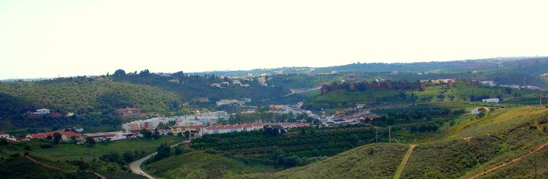
Approaching the end. Silves Castle in the middle distance.
- Now walk east of south, avoiding a turn to the right after 270m, onto a ridge and follow this line as it turns more due south. Arrive at a fork just after a dip, and take the right hand uphill, going more southeast after another 770m (15). Go down and then over a new height before descending quite steeply to the valley. (990m) Cross the stream (16) and walk up the path opposite to reach a tarmac road. Turn left and walk up the hill back to the start-point by the levada. (530m)
NOTE: If the stream is running high, you will have to turn left and walk the winding track to the N124 on the eastern edge of Silves. Turn right and then right again as soon as you can, to climb up through the suburb of Enxerim and find your way west back to the start. (1.6k)
Orientation: South is left. 37/ 8
GPS Points.
| 1 | At levada | 11 | 56 | 55 | 25 | 59 | 83 | ||||
| 2 | Under aqueduct | 11 | 55 | 89 | 26 | 13 | 72 | 420m | |||
| 3 | Monte Branco | 11 | 44 | 50 | 26 | 37 | 23 | 700m | |||
| 4 | Above house | 12 | 13 | 35 | 26 | 34 | 33 | 1.03k | |||
| 5 | Junction after valley | 12 | 32 | 39 | 26 | 40 | 18 | 740m | |||
| 6 | At ruin | 12 | 45 | 57 | 26 | 34 | 31 | 540m | |||
| 7 | On ridge 1 | 13 | 23 | 63 | 26 | 53 | 40 | 1.28k | |||
| 8 | On ridge 2 | 13 | 54 | 53 | 26 | 56 | 30 | 1.18k | |||
| 9 | Valley floor | 14 | 27 | 12 | 27 | 07 | 50 | 1.31k | |||
| 10 | Main road | 14 | 32 | 40 | 26 | 28 | 38 | 1.2k | |||
| 11 | Valley floor | 14 | 12 | 98 | 26 | 12 | 45 | 1.03k | |||
| 12 | Hairpin on hill | 14 | 02 | 41 | 25 | 40 | 60 | 960m | |||
| 13 | Turn in valley 1 | 13 | 36 | 59 | 25 | 38 | 47 | 1.13k | |||
| 14 | Turn in valley 2 | 13 | 22 | 27 | 25 | 35 | 88 | 640m | |||
| 15 | Fork on ridge | 12 | 49 | 25 | 25 | 46 | 30 | 1.07k | |||
| 16 | Stream crossing | 12 | 12 | 34 | 25 | 54 | 89 | 990m | |||
| End | 530m |