Walk Seventy. Sao Marcos da Serra – Monte Ruivo 17.5 kilometres Ascent: 340m metres
GPS: (37/8) 21.44.87 22.40.69
This is a comparatively easy walk from the small town of São Marcos da Serra, describing a semi-circle on either aside of the IC1 trunk road going north out of the Algarve. It encompasses low-lying farmland and slightly higher forest tracks, but nowhere are the ascents and descents too sharp. There are no refreshments on route other than in São Marcos and on the IC1 towards the end of the walk.
Getting to Sao Marcos.
From the A22 motorway or the EN125, take the IC1 north from near Albufeira. From the west you can pick up the IC1 at São Bartolomeu de Messines by driving along the EN124 from Silves. São Marcos is about 14 kilometres north of Messines. Leave the IC1 at the São Marcos exit and follow the signs to the town, which take you back over the main road. Turn right at the first junction and follow the road over the river and round to São Marcos. Enter via the Rua do Poleirão, which curves uphill and becomes the Rua Doutor Bernadino Ramos , turning another sharp corner at the top of the hill to become the Rua da Igreja (Church Street). See the church on the right through a narrow entrance and go through into the church square where you can park.
The Walk.
- Leave the square (1) the way you drove in and turn right down the Rua do Comercio. Follow this down the hill through the Largo da Cruz and along the Rua da Oficina to reach level ground by the railway. (360m) Go right along this road, round a wide sweeping bend. Come to a set of road signs on the right headed by Monte das Almas, and turn right in the direction indicated. (740m) (2). Ignore an immediate turn right and walk along northeasterly, ignoring several paths going off to the left, and taking the right hand lane at a fork, opposite a house on a rise, after 1.53k (3) Soon turn north-east again and walk 600m, at which the track kinks right. Here take the right hand at a fork and after a further 70m keep left at a junction with a track going off eastwards uphill. (4) Now walk along the valley through trees continuing east of north. The track begins to climb out of the trees after around 370m and over a rise.
- Come to a junction with a lane coming down from the left after a further 570m. Turn right down into a small valley and up the other side. Find a hairpin left (5) to join a track heading up the opposite side of the valley, due north. Follow this quite stony track along the valley floor for around 1.9 kilometres, crossing a number of small streams, probably dry in the warmer months. Arrive at a point where a track comes down from the right at an acute angle, and take the hairpin bend to join this track going uphill quite steeply. (6) Reach a small plateau at a track junction after 330m. Turn right towards some farm buildings, and just after reaching them (100m), turn sharp left downhill. Take the left at a fork after 940m (7). 150m on turn right and then left after another 100m. Stay right at the next junction after 170m, then keep left the one after that (130m), to arrive by the side of the IC1 main road 100m further on. (8)
- Cross the road either straight across with care or by using the bridge on your right. Find a track opposite to the point where you came up to the main road, running due east, and walk along it as it turns northeast after 160m. At the first fork after another 210m, go right uphill to reach a group of houses at the crest (330m). Swing round to the right past the houses, and at a fork, almost immediately, take the right hand, tending downhill. (9) Walk to the right of a small lake or barragem, and keep left at a fork about halfway along it (530m) as the track undulates east of south. After the fork the track turns more to the south-east, climbing. A track joins from the left after a further 620m, and you continue ahead, tending due south but winding, and now descending steadily over the next 1.79k. Another wide track joins from the left at the valley floor after the long descent. (10)
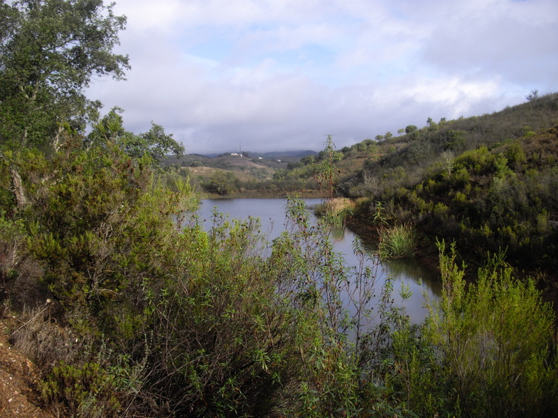
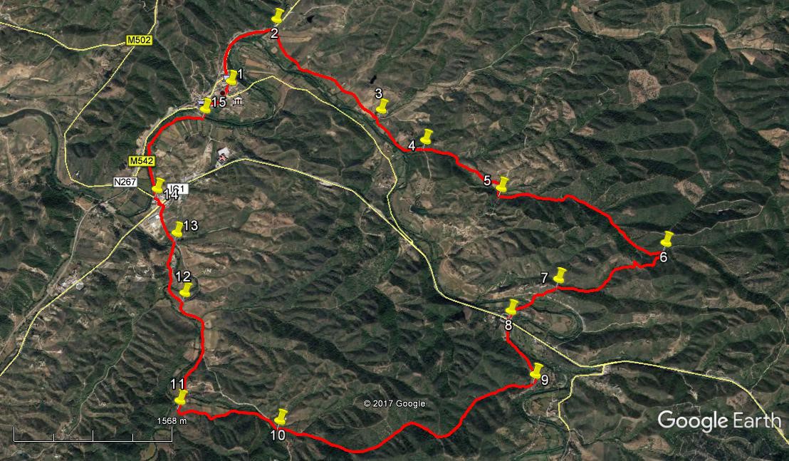
Barragem near Monte Ruivo.
- Turn right along it, but after 130m look for a track leading off at a narrow angle to the left and follow it first south-east for around 380m and then almost due south as it veers away from the line of the main track. After a further 220m, arrive at a small dam or barragem, walking across the front wall to continue more or less due south for a further 400m passing another barragem on the way, to reach a wider track at a junction. (11)
- Turn right, and follow this track back up to the main road, passing below a large farm. At the road after 660m, turn left. Follow the main road, passing between the buildings of an old water-mill. Coming to the top of a short rise 280m from the mill, see a turn to the left. Ignore this one, but take the next, very soon afterwards left at a cross-tracks (12) and walk down to a stream crossing in the valley (220m). (This might be wet after heavy rain) Climb the short hill beyond, and come to a cross-tracks after 180m, taking the road straight ahead, and down to the right of another barragem to a T junction after a further 320m. (13) Turn left.
- Walk along this tarmac road to the next T-junction, where you face the café on the IC1 at the São Marcos exit (410m). You now need to cross the IC1. This is a busy road by Algarve standards, at a complex junction, so best to cross by the road bridge over to the right. Walk right round until you are facing the café on the opposite side. Turn right, away from the IC1, but immediately turn right again on a track at the end of the river bridge facing you. (14) Now walk along the riverside path, staying close to the trees. Continue along this path for around 1.2k, following the curve of the river, and see the houses of São Marcos appear over to the left. (This riverside meadow seems to be very good for fungi at certain times of the year – interesting, but don´t be tempted! )
- Arrive at a narrow road and turn left to cross the river into the town. (15) Ignore a left and a right turn and turn right at a crossroads. You are now on the road on which you drove into town, so climb the hill and turn onto the Rua da Igreja to find the church square and your car. (410m).
North is right on google photo. 37/ 8
GPS Points.
| 1 | Sao Marcos Church | 21 | 44 | 87 | 22 | 40 | 69 | ||||
| 2 | Turn off main road | 22 | 02 | 92 | 23 | 05 | 13 | 1.1k | |||
| 3 | Fork Right | 22 | 33 | 71 | 22 | 19 | 29 | 1.53k | |||
| 4 | No right turn | 22 | 46 | 97 | 22 | 03 | 35 | 670m | |||
| 5 | After small valley | 23 | 09 | 54 | 21 | 38 | 36 | 1.07k | |||
| 6 | Hairpin bend | 24 | 00 | 39 | 21 | 05 | 32 | 1.9k | |||
| 7 | Turn to Monte Ruivo | 23 | 23 | 28 | 20 | 57 | 13 | 1.37k | |||
| 8 | IC1Crossing | 23 | 06 | 11 | 20 | 47 | 08 | 650m | |||
| 9 | Top of hill | 23 | 10 | 64 | 20 | 19 | 84 | 770m | |||
| 10 | Valley Floor | 21 | 45 | 84 | 20 | 16 | 95 | 2.94k | |||
| 11 | After barragems | 21 | 14 | 37 | 20 | 31 | 00 | 1k | |||
| 12 | Turn off main track | 21 | 20 | 27 | 21 | 14 | 52 | 1.31k | |||
| 13 | T junction | 21 | 20 | 04 | 21 | 39 | 95 | 720m | |||
| 14 | Turn before bridge | 21 | 15 | 33 | 21 | 59 | 62 | 550m | |||
| 15 | Turn to town | 21 | 34 | 71 | 22 | 30 | 63 | 1.2k | |||
| End | 410m |
NOTE. North is right.