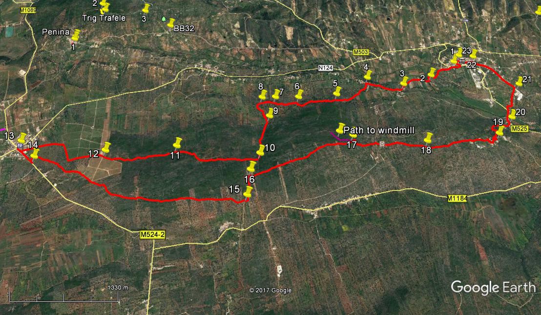
Walk Sixty Five. Salir - Benafim Circular. 19.5 kilometres. Ascent 425 metres.
GPS: 37/ 14 24 46 8/ 02 53 29
A walk between two of the small towns in the interior of the Algarve. Although quite long, it is not difficult. Gradients are not steep, and all tracks are clear, if sometimes stony underfoot. Strong contrasts are seen between cultivated land in the valleys and quite dense mato undergrowth on the hilltops. Also noteworthy are the large orange groves, quite recently developed, on the hill above Benafim. Refreshments are available at the start and at the halfway point in Benafim.
Getting to Salir.
From the south, take the IC1 road from the A22 motorway or the N125 near Albufeira, and travel north to Messines. Follow signs to Alte and Salir, going east on the N124. Pass through Alte and Benafim on this road and arrive at a roundabout, signed right to Salir. Go up the winding road and find the bar on the left soon after reaching level ground.
From further east, you can take the M525 north from Loulé to Salir. Follow the main road round Salir, pass the (unopened) fire station and petrol station and look for the bar on the right soon afterwards.
The Walk.
- - Cross the road from the bar, (1) and walk along to the right for a short way to find an information board and a path leading off beside it. Go along this path, ignoring three turns to the right and descending southwesterly on a winding road. Come to a bend at the bottom with gates on the left (2) (580m) and a bridge over a stream ahead. Cross the stream and continue along the floor of the valley, passing a number of wells and water storage tanks.
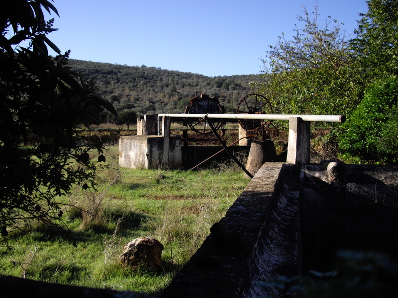
- Old well, near Salir. These water-raising mechanisms are locally known as Noras
- Arrive at a junction with a large house on the left (560m) (3). This small settlement is called Fonte Figueira. Turn right and almost immediately go straight across at a crossroads, leaving another large property on the left. Follow the road through some open country and then into the village of Almarginho.
- - Now look for a large bank of post-boxes on the left, facing you against the wall of a house. Immediately beyond this find a narrow lane going down to the left, (590m) (4) and walk along it. Soon curve to the right and onto a dirt track. Follow this round as it hugs the trees on the right, with open ground on the other side. Come to a narrow point (680m) (5) and the track kinks to the left and continues, now with trees on the left and open land right. After passing through areas that have clearly been cultivated, the undergrowth closes in, and the track becomes a rather narrow rocky path between scrub.
- - Maintain a westerly course across this wilderness, avoiding two clear turns to the right (630m) (6) and (380m ) (7). (The track does wind quite a bit, but the trend is always to the west). Reach a junction where the track turns northwest, and another one veers off southwest (200m) (8). Take this left-hand track and follow it as it crosses the valley floor, curving round to just east of south and becoming rather indistinct in places. Locate the beginning of a much more obvious track leading off uphill west of south (9) and climb with it to reach level ground, ignoring a turn to the left soon after this point. Come to a junction with a path on the right and turn onto it (740m) (10). Now follow this more or less due west once more, as it crosses a wide expanse of moor. The track turns northwesterly for a short time before resuming due west. Point (11) (1.24k) is a midway mark for reassurance.
- - At 2.34k from point 10 come to the edge of a large orange grove and turn along the lane beside it. Come to a cross-tracks after a further 150m and go straight across, (12) now with groves on both sides for a short time. Then the cultivated land is on the right as you walk down to a corner, turning right and soon after left to descend to a main road. Turn right to walk to a roundabout, then turn right again to find a café – there are two here, one next door to the other. (13) This is Benafim, although the most attractive part of the town is on the other side of the road, over to your left.
- - After refreshment – or not, as you choose – go back to the roundabout and turn left to go back down the road on which you entered. Go past the lane you came down earlier and take the next on the left, a wide sandy track, going sharply back left. (14) This quickly turns sharp right and heads southeast, passing along the bottom edge of the orange groves and away onto the moor. This stage covers around 3.3k, and the track gradually turns more due east. See a settlement below in the later stages, and when you have walked past it, come to a T junction in the track (15). Turn left uphill following a cleared area between scrub on either side.
- - Climb quite steeply, and find a track on the right after (16) There is actually one coming in from the left, but it is quite narrow and faint. Turn right and walk northeasterly across another large expanse of uncultivated scrub, for around 1.59k. Arrive at a point where the track is beginning to descend and see a track leading off uphill on the left. (17) A short diversion along this will take you to a ruined windmill hidden in the trees at the top of the hill. (Route marked in purple on the photo). If this does not attract you, turn right downhill and follow the track to a tarmac road. (390m) Go diagonally right across the road into a narrow tarmac lane and into the tiny settlement of Portela da Nave. Walk straight through between the houses and onto a dirt track immediately after the last house.
- - Another track comes in to join from the left. Continue ahead and shortly pass a dwelling with stacks of firewood alongside the track. (680m) (18). Carry on and start to climb steadily. After reaching level ground, soon come to a tarmac surface at the boundary of the hamlet of Covões. Follow the road as it descends, at first straight and then winding as it meets the centre of the settlement. Come to an area of open ground beyond the houses, still descending, and see a wide path on the left with a concrete electricity pylon just beyond it and a large rubbish bin opposite. (1.13k) (19)
- - Turn down here and descend steeply down this stony lane, passing a fonte (well) as you round a corner onto a concrete road. Carry on down the hill to come to a main road at the bottom and turn left. This little group of buildings (with a small café up to the right if you are interested) is Ponte de Salir. (660m) (20) Go down and cross the bridge (ponte), and then take the road facing you, signed to Palmeiros and Cemetério, climbing the hill on a winding route to reach the corner of Salir cemetery at a junction. (730m) (21). Turn left and walk along the road into Salir. At the first junction go straight across and uphill on a narrow road. At the next junction, with a bank on the right, (830m) (22) go left and walk down the main street of the town. Pass two restaurants on the left and see the farmácia (chemist) on the right. Turn left here (220m) (23) and then take the second left to go down a narrow cobbled lane onto a main road. Turn right to make your way back to the bar from which you started. (250m)
Orientation normal. 37/ 8
GPS Points.
| 1 | Bar Opcao | 14 | 24 | 46 | 02 | 53 | 29 | ||||
| 2 | Corner with gates | 14 | 18 | 13 | 03 | 09 | 84 | 580m | |||
| 3 | Fonte Figueira | 14 | 14 | 12 | 03 | 28 | 76 | ||||
| 4 | Almarginho | 14 | 19 | 62 | 03 | 50 | 23 | 590m | |||
| 5 | Kink in track | 14 | 11 | 28 | 04 | 11 | 52 | 680m | |||
| 6 | No right turn 1 | 14 | 11 | 39 | 04 | 34 | 93 | 630m | |||
| 7 | No right turn 2 | 14 | 12 | 49 | 04 | 48 | 89 | 380m | |||
| 8 | Turn across valley | 14 | 13 | 02 | 04 | 56 | 90 | 200m | |||
| 9 | Bottom of hill | 14 | 01 | 83 | 04 | 53 | 97 | 410m | |||
| 10 | Turn at top | 13 | 40 | 45 | 05 | 02 | 11 | 740m | |||
| 11 | Midway mark | 13 | 48 | 41 | 05 | 48 | 16 | 1.24k | |||
| 12 | Orange grove crosstracks | 13 | 49 | 95 | 06 | 28 | 09 | 1.25k | |||
| 13 | Benafim bar | 13 | 59 | 72 | 07 | 16 | 56 | 1.35k | |||
| 14 | Return turnoff | 13 | 51 | 29 | 07 | 08 | 30 | 370m | |||
| 15 | Turn uphill | 13 | 22 | 14 | 05 | 11 | 47 | 3.3k | |||
| 16 | Turn towards Portela | 13 | 33 | 10 | 05 | 08 | 24 | 360m | |||
| 17 | Turn to windmill | 13 | 44 | 82 | 04 | 08 | 68 | 1.59k | |||
| 18 | Woodstack | 13 | 38 | 88 | 03 | 27 | 10 | 1.08k | |||
| 19 | Covoes | 13 | 39 | 58 | 02 | 44 | 45 | 1.13k | |||
| 20 | Ponte de Salir | 13 | 49 | 48 | 02 | 30 | 51 | 660m | |||
| 21 | Cemetery | 14 | 07 | 47 | 02 | 18 | 25 | 730m | |||
| 22 | Bank corner | 14 | 26 | 45 | 02 | 40 | 07 | 830m | |||
| 23 | By restaurants | 14 | 28 | 04 | 02 | 48 | 72 | ||||
| End | 250m |