Walk Sixty Four. Salir – Ameixial Linear Walk. 23k. Ascent: 1068m
GPS: 37/ 14 31 05 8/ 01 16 58
A long and very varied walk from just outside the small town of Salir, north to the large village of Ameixial, near the border with the Alentejo, the next province. This is a linear walk, so you will have to make transport arrangements to get you back to Salir. There are taxi services, but these are best explored when you want to do the walk. There is one river to cross, but you have to do it three times. After heavy rain this could be difficult, but it is near the start of the walk, so if you have to turn back there is not far to go. There are no refreshments on the route, but there are bars at start and finish.
Getting to Salir.
The walk actually starts at the café in a hamlet called Besteiros, which is outside Salir. To get there from the south, take the IC1 road from the A22 motorway or the N125 near Albufeira, and travel north to Messines. Follow signs to Alte and Salir, going east on the N124. Pass through Alte and Benafim on this road and arrive at a roundabout, signed right to Salir. Ignore this and go straight on along the 124. The bar is on the left after about 2k.
From further east, you can take the M525 north from Loule to Salir. Follow the main road round Salir to reach the roundabout on the N124 and turn right to find the bar after 2k.
The Walk
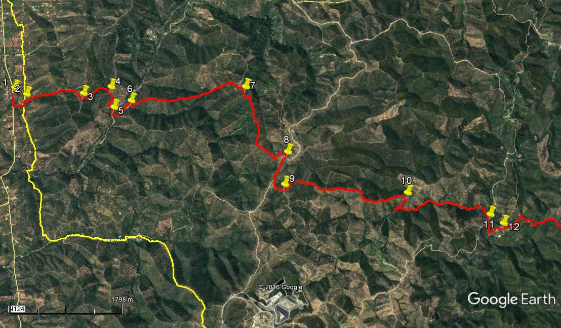
- There are quite a number of settlement names in the Algarve that belong to more than one place. On this walk we have two places called Besteiros. So, from the bar at Besteiros ´A´, (1) turn left along the road and take the first turning left on a concrete road after 180m which turns left after another 170m. 100m along, see a dirt track going off to the right (2) and turn along it, staying right at a fork 110m further on. Walk along the pleasant wooded valley, staying right at another fork after 440m, and then starting to rise steadily. Come to a cross-tracks after another 480m (3) on level ground overlooking a valley, and go straight across and downhill. Stay right at a fork on the descent (100m), and then swing left along the valley. Stay right at a fork after 320m as the track swings round to the right, now rising again. At another cross-tracks on the ridge after another 210m (4), go straight across and follow the track as it winds down into a deeper valley with a river at the bottom a further 520m on. (5)
- Cross the river here and walk forward 100m before swinging left along the valley floor to cross again after 210m. Walk ahead for another c100m to find a third crossing point, after which turn back sharp right to walk across to where a narrow valley opens onto the valley floor . (The second and third crossings are necessary because there is impassable vegetation on the near bank). Walk into the valley for a short distance and then take a track on the left (6) that climbs steeply, winding round to face due north. The gradient eases after a while, runs level and then descends a little, always tending almost due north. Pass a point where a track comes in to join from the right and start to rise quite steeply again, still on the northward course, until the track curves more to north-east and joins another track coming in from the left after 1.97k. (7)
- Turn right along this new, undulating track, and pass a lone house on the left after 410m – it is called Ludeu, and there are the ruins of other buildings round about, hidden in the mato (undergrowth). A little past the house the track swings left and continues to climb slowly, to meet another wide track at a T junction after just over another kilometre. (8) Turn sharp right here and walk for 410m south-east to a junction with a narrower track on the left. Take this due east and then north-east to reach a fork after another 240m.(9) Turn left here away from a low hill and turn right with the track after 210m as it first of all rises a little more and then starts to descend a long ridge, heading east of north. After a brief kink to the east after 1.1k, it resumes almost due north, to arrive at a cross-tracks after another 650m (10) where one track goes ahead and starts to rise again and the one crossing descends on both sides..
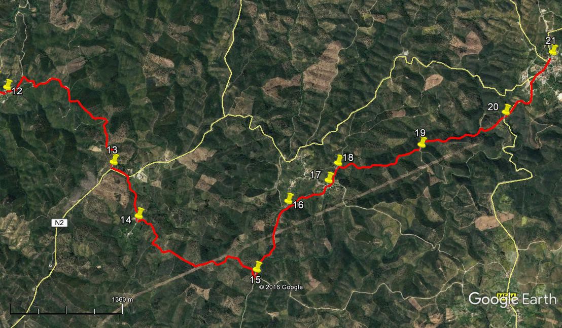
- Take the right hand track and go steeply down to a valley, turning a hairpin left at a junction after 250m. Walk along the valley on a gently undulating track for 1.76k, going straight ahead where a track comes in from the left. Now heading east of north again, begin to see a settlement ahead. This is the isolated settlement of Fornalha. The track turns more to the east over the final 230m to the valley floor. (11) Go straight ahead across the river, swinging right almost immediately, to come to a junction after 180m. Take the first left to wander up through the lower part of Fornalha for 230m, emerging onto a wide dirt road. (12) Turn left and then follow the road round to the right, ignoring a left turn on the curve. Pass the remaining houses of the village and walk up for 390m to a junction. Turn right and now simply follow the wide gravel road for 2.69k, as it climbs steadily out of the valley. Arrive at the junction with the main N2 road. (13). This is a convenient pickup point for anyone not wishing to continue the walk, as the road leads south to Barranco do Velho and then (via the N124) back to Salir.) Turn left here and walk the straight stretch of road to the next junction on the right. 240m Turn down this lane, which leads to the small settlement of Cavalos. Pass the first block of buildings on the left, and turn left on a track immediately after the second. 610m (14)
- Walk along to the first junction (a cross-tracks) (230m) and turn right. Walk first on level ground, more or less north-east, and then climb to a high point after 540m, ignoring all turns to the right. Now descend steadily north-east, then due north, then north-east again, over 1.19k, to reach a cross-tracks (15), turning left here. Now descend to the valley floor, heading north-west, crossing the small stream at the bottom,(ignore a turn to the right soon after) to reach a hairpin bend to the left after 1k. (16) At the apex, take a much narrower track going ahead more or less due north. Walk along this for 530m, starting to rise as you go. Ignore a fairly obvious track on the right and reach a junction by swerving left in front of a building. Turn left along the new track into the settlement of Besteiros (B).
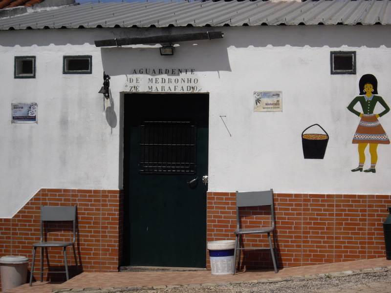
Firewater for Sale. Besteiros ´B`
- Walk up the hill for 100m and turn right at the next junction, (17), and then take the next on the left after a further 100m, a narrower less obvious track going through grassland to meet a wider track on level ground after 210m more (18). Turn right here and go up for a short distance and then begin to descend gently, more or less due north for 1.21k. (19) Here at a junction the track kinks briefly to the left and then continues down to the valley floor over a further 1k. Once on level ground, opposite a patch of cultivated land, look for a turn to the right and take this track as it rises quite steeply to meet a wide tarmac road after 350m. (20). Turn left along the road to walk into Ameixial. Bear right at the cemetery, right again at the next junction, and walk along into the village, to find the café opposite the petrol station after 1.12k. (21).
Orientation. Left is south.
This walk crosses the GPS line between 37/ 8 and 37/ 7. First seven entries are in 8.
GPS Points
| 1 | Besteiros `A` | 14 | 25 | 92 | 01 | 22 | 49 | |||
| 2 | Turn off concrete | 14 | 31 | 13 | 01 | 16 | 46 | 450m | ||
| 3 | Top of hill | 15 | 00 | 21 | 01 | 07 | 62 | 1.03k | ||
| 4 | Second crest | 15 | 14 | 73 | 01 | 07 | 30 | 590m | ||
| 5 | River crossing 1 | 15 | 12 | 97 | 00 | 54 | 90 | 520m | ||
| 6 | Bottom of climb | 15 | 22 | 29 | 00 | 56 | 33 | 420m | ||
| 7 | Top of long climb | 16 | 21 | 11 | 00 | 45 | 51 | 1.97k | ||
| 8 | Junction after Ludeu | 16 | 33 | 53 | 59 | 59 | 45 | 1.5k | ||
| 9 | Left off main track | 16 | 28 | 26 | 59 | 40 | 40 | 650m | ||
| 10 | Sharp right | 17 | 26 | 23 | 59 | 16 | 85 | 2.14k | ||
| 11 | Below Fornalha | 18 | 04 | 20 | 58 | 51 | 00 | 2.01k | ||
| 12 | Above village | 18 | 08 | 77 | 58 | 43 | 94 | 460m | ||
| 13 | At N2 | 18 | 46 | 72 | 57 | 51 | 05 | 3k | ||
| 14 | Turn at Cavalos | 18 | 51 | 34 | 57 | 21 | 25 | 850m | ||
| 15 | Left at cross-tracks | 19 | 32 | 22 | 56 | 40 | 25 | 2.07k | ||
| 16 | Turn off near Besteiros ´B´ | 19 | 51 | 42 | 57 | 10 | 16 | 1k | ||
| 17 | Besteiros `B´ | 20 | 09 | 38 | 57 | 15 | 58 | 630m | ||
| 18 | Past Besteiros `B` | 20 | 14 | 89 | 57 | 22 | 99 | 310m | ||
| 19 | Fork | 20 | 50 | 60 | 57 | 21 | 72 | 1.21k | ||
| 20 | Main road | 21 | 28 | 59 | 57 | 27 | 61 | 1.36k | ||
| 21 | Ameixial cafe | 21 | 54 | 15 | 57 | 52 | 29 | 1.12k | ||