Walk Sixty Three. Sagres – Salema Linear. 16k. Ascent: 630m
GPS: 37/ 00 34 85 8/ 55 55 68
This is an exciting linear walk from the town furthest west in the Algarve, along the still largely unspoiled coastline, ending at the small but expanding tourist/ fishing village of Salema. It is physically demanding and there are some very steep ascents and descents, as well as a narrow path halfway down a cliff towards the end (this can be avoided.) With the exception of a few kilometres near the start, the track runs very close to the sea, so getting lost is not easy.
Getting to Sagres.
From all points east, follow the A22 coastal motorway to the Lagos/Vila do Bispo junction. Take the motorway spur from here towards Lagos and on reaching the N125 turn right towards Vila do Bispo and Sagres. Drive along this road to Sagres. Approaching the town, a long straight section of road goes into a dip and up again – note a small tower with a conical roof at the top of the rise. Arrive at a roundabout at the top of the rise and turn left, signed Centro and Baleeira. Follow signs to Baleeira until reaching a sharp right-hand bend, with the harbour ahead below and a new hotel over on the left. On the street corner left see the Pastelaria Baia. This is your start-point. Allow about 25 minutes from Lagos. If you need to leave a vehicle at Salema, you must turn left off the N125 at the appropriate sign, and make your way down to the car park on the sea-front.
Because of the nature of the terrain, it is inadvisable for inexperienced walkers, or anyone suffering from a fear of heights, or vertigo, to attempt this walk. Walking sticks are recommended.
The Walk.
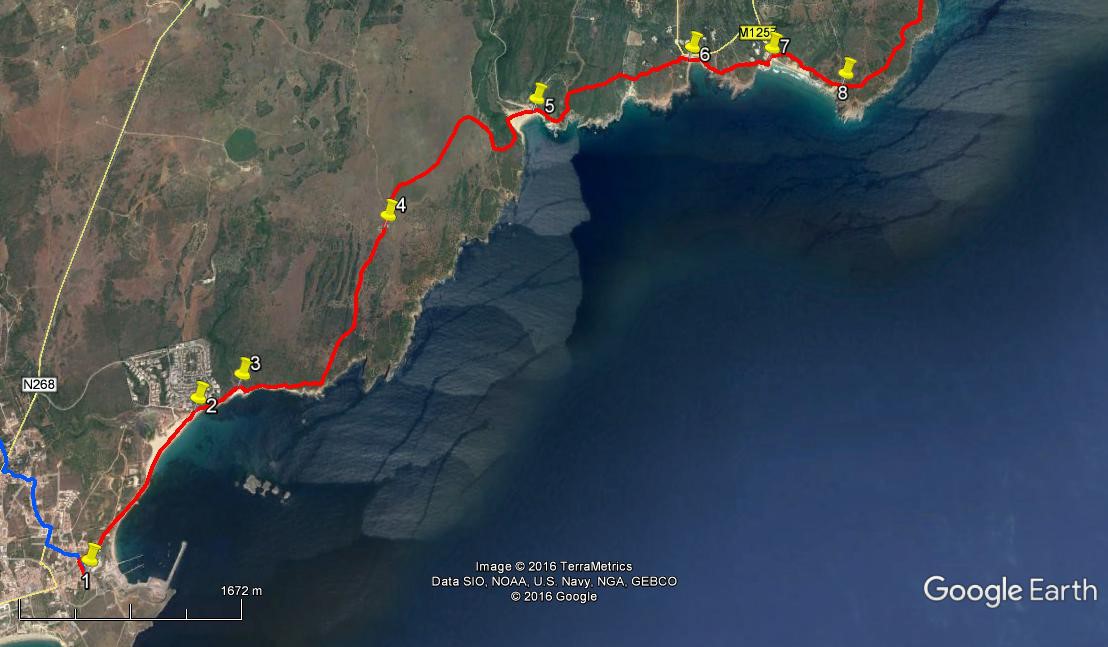
- With your back to the Pastelaria Baia (1) (and hopefully with their coffee and cake inside you), turn right. Immediately turn right again down the pedestrian lane Rua Jaime Conde. Pass an old factory with an interesting sculpture on the left and the café Pôr do Sol on the right. Turn right at a cross-roads, and walk down past a hotel on the right, as the road turns to a dirt-track. Note the sea and cliffs ahead, and the harbour appearing on the right. At a fork bear right towards the beach. Reaching the sand, ( 900m from start) walk along the beach towards low cliffs at the far end, passing two wooden beach cafés. About 120m from the cliffs, opposite a large hotel building, turn left over rocks to a narrow path leading up from the beach. 1.56k from the start. (2)
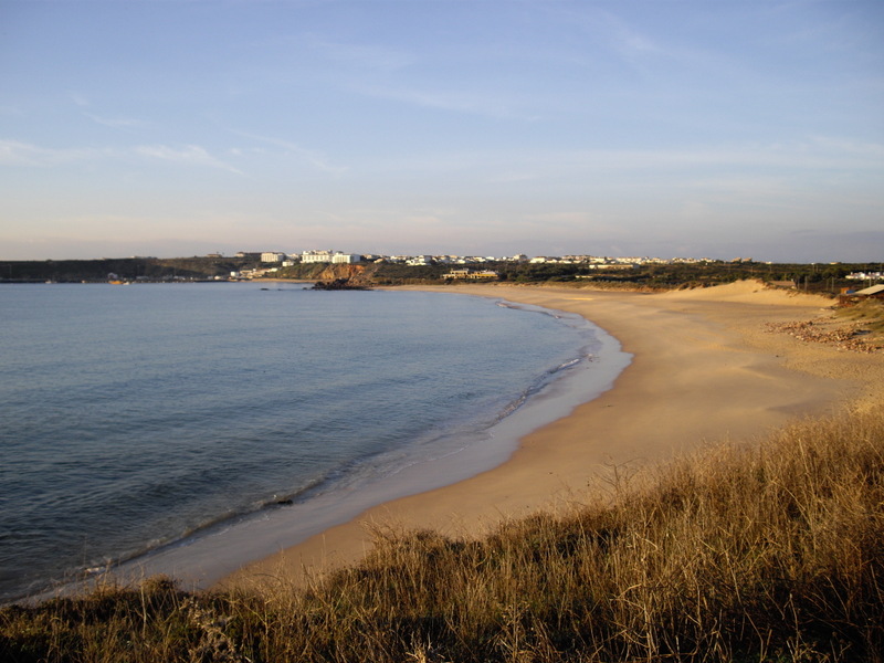
Sagres Beach, looking back to the town.
- Stay right, quite close to the shore, on this path to walk along the cliff top north-eastwards below a group of houses. Join a wider track and continue forward below two large villas. Swing up to the left and over a small headland, down into a small rocky cove after a further 410m. (3) Cross the cove and the river or river bed and climb a clear path up the rocks, heading seaward and emerging onto the cliff top to follow the track along, now heading more or less due east, for around 670m.
- On this stretch, look over to the left on a rise to see a large farm building on the horizon This is your next target. About 100m from a line of low rocks ahead, turn left on a track to see the farm building clear ahead. The track soon becomes a double earth path with grass in the middle, and it winds and climbs very gently towards the farm over 1.35k. Just before the farm join another track at a T junction and turn right to pass to the right of the farm. (4) Go forward from here with a windfarm ahead and a trig pillar over to the right.
- At a fork after 110m bear right on a gently rising track. Follow this track generally north-eastwards for 1k, heading for a low ridge. Around 200m from this, find a track veering off right at a narrow angle, and follow it as it describes a semi-circle over the next 440m, to end up facing almost due south. In a sandy hollow, find a track on the left at right-angles to yours, and follow it as it curves left and narrows after around 100m. It bends round to north and descends quite steeply, diagonally across the face of a hillside, to a beach, after around 420m. This is Praia do Barranco.
- Look across the beach to see a path climbing back seawards up the cliff. (5) (Ignore a much wider track over to the left). Follow this narrow path as it describes a semi-circle round the headland, meeting a wider track coming up from the sea after 250m. This heads north for a further 240m – building on the left along here - before meeting a track coming in from the right – turn onto this track and walk, now facing north-east for almost 500m before meeting another track coming in from the left. Stay on the same track, heading towards scattered houses and descending, over a further 590m. Just before hitting a tarmac road, turn right by the side of a stone building to emerge onto another beach. (6)This is Praia da Ingrina, and if you are lucky, the café could be open.
NOTE. The descent to the next beach is very steep, so if you wish to avoid it you can walk round on the tarmac road behind the café – some 890m.
- Past the café on the beach find a rocky path heading up the cliff edge, south-easterly. Walk parallel to the sea for around 120m. Now pass to the right of an area of cultivated land and follow the track as is curves left and climbs a little to reach a broad track running roughly north-south across your line after another 150m. Go straight across into another narrow path. Follow this across the open land, rising steadily over 200m, coming close to a large house on the left. Stay on the track past the house, as it begins to descend and becomes rocky and very steep. It heads out towards the sea for a time and then turns back inland, to come down to another beach. (7) This is Praia do Zavial, with another café, sadly often closed in the winter months.
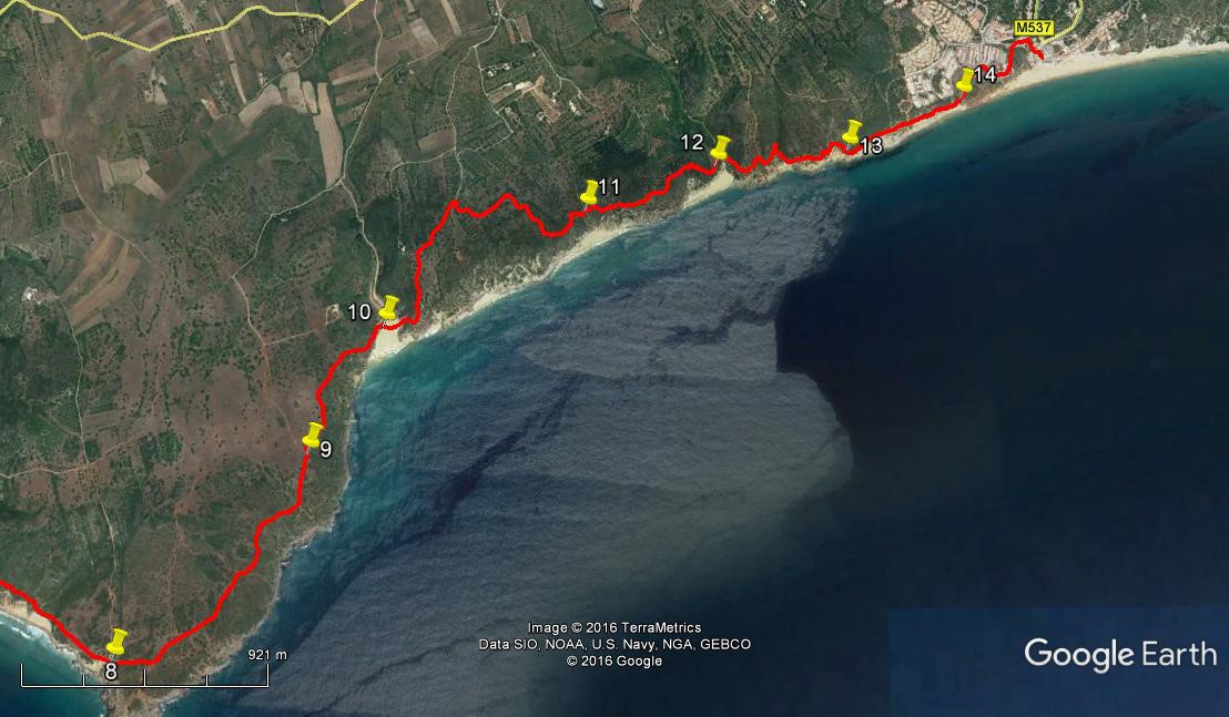
- Cross the beach to find a path behind bushes which turns steeply uphill and rises to a summit above the beach. From here the path follows the coast south-east for a further 750m on an undulating track that takes you down close to another beach and then climbs again. At the end of this distance, come to a wide track crossing at right angles (8). From here walk around 150m due east along quite a wide track, with a small `island´ of bushes halfway along. Come to the next track junction, again with a bush in the centre, turn north-east and follow the still clear track. Ignore a turn to the left after 120m, and continue in this direction for around 470m altogether, coming to yet another ´island´ junction. Turn right and immediately left to go through a smaller island and continue the north-easterly course for a further 390m, on a far narrower and slightly less distinct path. It turns almost due north for a further 180m, still parallel with the coast, arriving at a junction with a wider track (9) which heads off west of north towards a white house some distance away.
- See a narrow path across from the point at which you joined the wider one, heading due north, and take this. It turns more north-east after less than 100m, rounding a bush and coming up close to an old field wall after a further 110m. Turn to walk alongside the wall for about 120m heading more or less due north, then cross the wall-line, heading in the same direction for a short distance, after which the path turns more north-east again for another 170m. Here there is a further half-turn right and the beginnings of a steep descent to another beach. Follow the path as it turns to the north halfway down and cuts across the face of the slope to reach the beach, Praia das Furnas. (10)
- Getting off this beach is not easy. Walk across to where sand has been piled up against the cliff and work out your own way to climb the lower rocks and locate paths going out towards the sea and then rounding the hill to find a main track leading north away from the headland. (c150m). Walk up this track for around another 200m, to come to a junction close to a very distinctive dwelling on your left. Turn away from this after viewing, and walk more or less north-east up a well-defined track for a further 290m. Here turn sharp right and then very quickly left at a fork. This track takes you first easterly and then south-east back down to the coast in a valley after another 520m. Now see a track heading south-east uphill away from the valley and follow it up and over the next hill, to drop down into another, rather deeper valley after around 230m (11).
- Go straight across the bottom of the valley and climb the very steep rocky slope ahead for about 100m. Come to a junction where one track continues up the hill and the other heads off less steeply in a generally south-east direction. Take this second one and curve around the hill. After around 100m it turns north east and then shortly more easterly, to undulate through trees and scrub for around 190m. It then detours very briefly left and right round bushes, to resume the same line for a further 100m, curving back right and then left at the end of this diversion, to resume a general north-easterly track, winding through trees, for another 180m. Now reach the edge of a very steep descent through pine trees down to another small beach, Praia da Figueira. (12)
- Walk up the valley away from the sea for around 100m, then cross over and take the rocky path heading back to the sea and climbing. Reach the ruins of an old fort at the top (Forte de Figueira). Walk through the ruins and find a broad track ahead. Walk along for about 100m, then turn sharp right towards the sea for a further 50m, branching off left on a narrower path taking you up the side of a narrow valley above a small beach. 100m into the valley, cross over and come back down the other side to pick up a path leading due east away from the small beach. There are several paths here on this broken area of coast. Head east on any of them, towards an area where erosion has taken a crescent-shaped bite out of the land. Work your way round this, coming down the other side into a rocky valley close to the sea. (13) (c300m from the small beach.)
- Now climb the rocky ridge ahead on a narrow path, keeping to the landward side of rocky outcrops, as the cliff edge is very close. Climb steeply for 160m, to a fork in the track. Here is an important decision. Taking the right hand path will lead you on an exciting but a little precarious track overlooking the sea. If you don´t fancy that, taking the left hand will bring you up to the outskirts of Salema and all you need do is find a tarmac surface and walk downhill to reach the village centre and the end of your walk. (1.13k from the fork). To pursue the more daring option simply follow the right hand path as it runs along a narrow flat area part-way down the steep slope below upper Salema. You need to take care, walking in single file. Anyone with a fear of heights should NOT choose this option. After about 420m from the fork, (14) where one track dips down towards the sea, fork left on a track that turns away from the sea and leads after another 100m to the end of a tarmac road. Walk along to the junction and then downhill to the village centre, a further 540m.
Orientation normal. (2 photos)
GPS Points.
| 1 | Pastelaria Baia | 00 | 35 | 69 | 55 | 57 | 30 | |||
| 2 | End of Sagres Beach | 01 | 15 | 37 | 55 | 26 | 60 | 1.56k | ||
| 3 | At inlet | 01 | 21 | 39 | 55 | 13 | 00 | 410m | ||
| 4 | Farm | 02 | 02 | 14 | 54 | 27 | 26 | 2.15k | ||
| 5 | Exit Praia do Barranco | 02 | 34 | 21 | 53 | 38 | 92 | 2.18k | ||
| 6 | Praia da Ingrina | 02 | 48 | 20 | 52 | 46 | 72 | 1.66k | ||
| 7 | Praia de Zavial | 02 | 47 | 97 | 52 | 20 | 04 | 800m | ||
| 8 | Cross-tracks | 02 | 39 | 87 | 51 | 56 | 39 | 850m | ||
| 9 | Turn-off to beach | 03 | 04 | 45 | 51 | 28 | 08 | 1.19k | ||
| 10 | Praia das Furnas | 03 | 20 | 92 | 51 | 17 | 29 | 640m | ||
| 11 | Valley ner sea | 03 | 35 | 41 | 50 | 45 | 17 | 1.39k | ||
| 12 | Praia da Figueira | 03 | 41 | 48 | 50 | 24 | 01 | 700m | ||
| 13 | Stony Valley | 03 | 43 | 42 | 50 | 02 | 55 | 850m | ||
| 14 | Turn to tarmac | 03 | 50 | 21 | 49 | 43 | 70 | 580m | ||
| End | 540m |