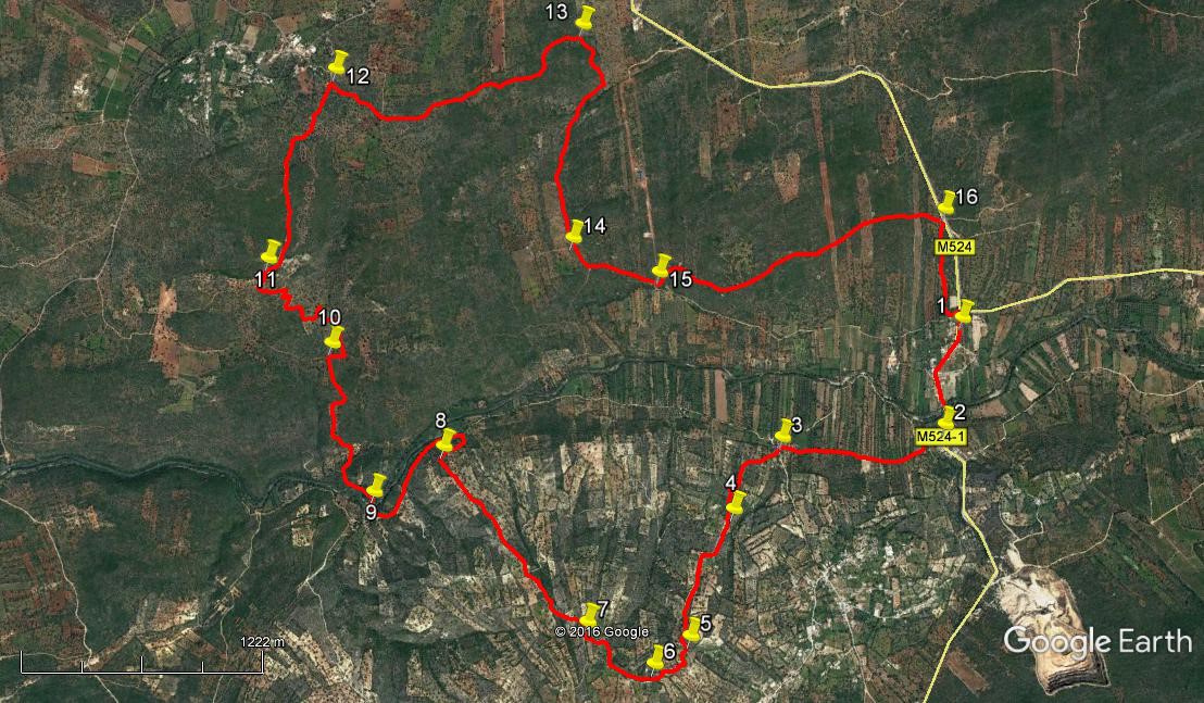
Walk Sixty One. Ribeira de Algibre. 15 kilometres. Ascent: 500m.
GPS: 37/ 11 25 66 8/ 05 01 09
This walk involves two hill climbs on either side of the valley of the R. Algibre, taking in a near-abandoned hilltop village and approaching another very much alive. Care should be taken to assess the river level before starting out, as the crossing near the halfway point could be impassable after heavy rain. There are no refreshments on route, and you should note that the Bar Reguengos is closed on Saturdays.
Getting to the Bar Reguengos.
From the roundabout at Boliqueime on the N125, take the N270, signed to the A22 motorway. (If you come along the A22, take the Boliqueime exit and follow signs to Loule.) Go over the motorway, pass a petrol station on a road over to the left, and swing right to climb below a rocky cliff. Pass quarry workings on the left and take the next left, signed to Alte and Benafim. Pass through the village of Parragil and turn left at the T junction. Stay on the main road down a long hill, pass another quarry up on the right and enter the hamlet of Ribeira de Algibre. Drive through and over the narrow river bridge. About 400 metres on, just before a junction with the road to Tor, find the bar, the last house in the village.
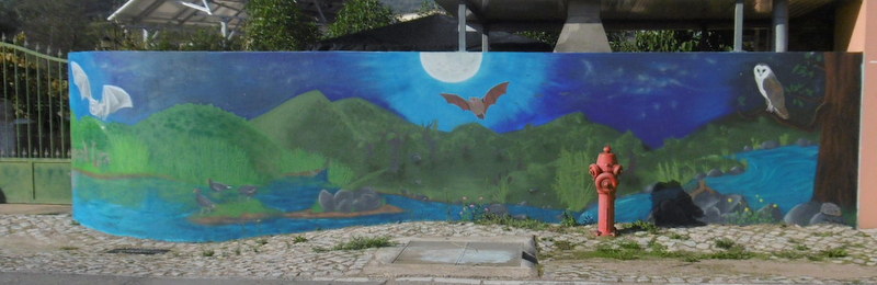
Part of a fine new mural, Ribeira de Algibre
The Walk.
- Leaving the Bar Reguengos, (1) go down through the village on the road, crossing a narrow bridge over the river. After the bridge go round to the right, and immediately before the first building on the right, turn right down a track. (2) (Litter bins on the right, big yellow arrow on the wall left.) Soon come to a junction. Take the second left and at a fork soon after bear right, going forward on level ground. Follow this valley track to another junction. Ignore the wide track leading off to the left, and take the less obvious one almost straight across, tending uphill, southwesterly, under trees. (3)
- The track trends steeply uphill first for 190m WSW, then for 130m SSW to reach a T junction with another track leading across the hill. Turn right here and follow this new track as it quickly turns uphill again towards a white house visible through trees. Follow the track as it passes to the left of the house and comes up to a junction after another 220m.
- Turn left and at another junction after less than 100m turn right uphill (4) The path ascends with some extremely thick stone walls alongside. It finally begins to level off in more open country, with houses and another trig pillar visible over to the left.
- Before reaching level ground, after around 740m (5) turn off the path in a southwesterly direction, crossing the brow of the hill on open, pathless land to discover the hamlet of Cabeças de Monte Seco hidden in vegetation over to the left after around 240m. (6) This small settlement was completely abandoned, but is now being slowly restored building by building. Walk down between the main row of houses, passing a fully restored cottage at the end on the right. Ignore turns to the left (these will take you to a main road and bus stop if you are ready to call it a day!) and follow the stony track on level ground northwesterly out of the hamlet. Turn quite sharply right after 240m and follow the track as it descends quite steeply, curving left, to a junction with a wider track after another 210m (7). Turn right and swing left with the track, ignoring tracks to left and right as you descend, heading northwest. After 1.24k the track turns sharply right (8) and drops to a wide dirt track running along the valley floor. Turn left along this.
- Walk along parallel to the river. After rounding a left hand curve, see a track forking to the right tending downhill after 640m, and take this as it leads down to the river bank – a further 100m. You need to cross here. (9) (If the water level is too high, you have no choice but to turn round, go back to the main track, turn left along it and follow it all the way back to Ribeira do Algibre and the bar where you began.) Once across the river, turn right and immediately left to find a way through the river bank vegetation. Then follow this rising track as it parallels the river, heading northwest, for about 220m, until it turns right. Ignore a track going off left at this point and walk for 100m to a fork, taking the left hand, running for another 100m along the left hand edge of a more open cultivated patch of ground. Now turn left with the track for a further 110m, heading northwest again, after which come to an open area dotted with olive trees and walk due north up through them for around 170m.
- Coming to a point where dense, tall scrub bars your way, bear right to find the narrow exit path from the olive grove. This starts right then turns immediately left to continue the uphill trend for a further 250m. Meet another wider track at a T junction (10) and turn right, turning left after about 100m to continue on the northerly line. A short, straight section of around 180m follows, after which the track, clearly visible, turns left across a small depression and begins to wind as it trends more steeply uphill. It first describes quite a sharp turn right, then up and round a hairpin left, followed by a another sharpish turn right and a short straight section – all this over about 220m. It then trends more definitely northwest, but still winding through four considerable bends. Rounding a final hairpin to the right, with the gradient easing, a large house appears ahead. Walk to this house and pass it on the left. (760m) (11)
- Now walk along the wide lane, rising slowly and then on level ground, until you reach a small cleared area on the left after 1.1k. (12) (Just beyond this point is a T junction with a similar wide track. If you reach this you have gone too far.) Just after this clearing, find the beginning of a track going sharply back on the right. Note. If you need assistance, or wish to end your walk, the village of Espargal is just around the corner on the left from the T junction. There are no facilities in the village, but you could get transport if necessary.
- Take the track on the right and follow it gently downhill south-east for around 330m, to meet another at a cross-tracks. Cross straight over here, and follow the narrow, winding path as it rises slowly and then descends over 1.23k. Pass some old polytunnel structures on the left, and further down on the right one of the old lime burning pits used by local people in the past to make the whitewash to decorate their walls. Almost immediately after the lime pit, come to a junction and turn right downhill. (13) The path at this point is rather overgrown, but it does lead to a better one after almost 300m. At this better track, turn right and continue to descend.
- The track describes a wide arc to the left as it descends for about 930m (14). After this, join a wider track and continue downhill for another 130m. Arrive at a junction and turn left. Now look for a turning left uphill on a stony track by a fence after a further 360m (15) Follow this track as it trends first northeast, then southeast, then generally northwest again up and over an area of open country. You will pass another three lime burners, but you may not see them all. Cross over two areas where the land has been cleared – and possibly planted as time goes by – and after about 1.69k, come up to a main road. Walk down this road for about 550m to reach the café from which you started the walk. Alternatively, to avoid the road, you can take a track that starts on the right about 50m back from the main road and runs parallel with it. (16) This becomes indistinct after a while, but pass a large electricity pylon, walk on the same line through olive groves to the bottom of the hill, then walk a short distance across a meadow to reach a tarmac road. Turn left here to reach the main road again very shortly, and then turn right for the bar.
Orientation normal. 37/8
GPS Points.
| 1 | Bar Reguengos | 11 | 25 | 66 | 05 | 01 | 09 | |||
| 2 | Turn off main road | 11 | 07 | 98 | 05 | 06 | 74 | 620m | ||
| 3 | Bottom of hill | 11 | 08 | 08 | 05 | 40 | 88 | 920m | ||
| 4 | Past white house | 10 | 57 | 05 | 05 | 52 | 41 | 640m | ||
| 5 | Turn to Cabecas | 10 | 37 | 24 | 06 | 03 | 64 | 740m | ||
| 6 | At Cabecas | 10 | 33 | 38 | 06 | 11 | 45 | 240m | ||
| 7 | Descent from Cabecas | 10 | 41 | 34 | 06 | 24 | 23 | 450m | ||
| 8 | Turn to valley | 11 | 10 | 98 | 06 | 51 | 50 | 1.24k | ||
| 9 | River crossing | 11 | 04 | 15 | 07 | 06 | 88 | 740m | ||
| 10 | Wide path crossing | 11 | 29 | 33 | 07 | 13 | 08 | 950m | ||
| 11 | Large house | 11 | 43 | 77 | 07 | 23 | 92 | 940m | ||
| 12 | Near Espargal | 12 | 14 | 02 | 07 | 07 | 25 | 1.1k | ||
| 13 | Turn after polytunnels | 12 | 18 | 58 | 06 | 15 | 67 | 1.56k | ||
| 14 | At clear track | 11 | 43 | 76 | 06 | 21 | 25 | 1.23k | ||
| 15 | Turn uphill | 11 | 36 | 97 | 06 | 03 | 73 | 490m | ||
| 16 | Turn before road | 11 | 43 | 75 | 05 | 02 | 89 | 1.6k | ||
| End | 550m |